
7 Dekalb
7 DeKalb Ave,
Brooklyn, NY 11201
1-2 Beds $4,396 - $6,688
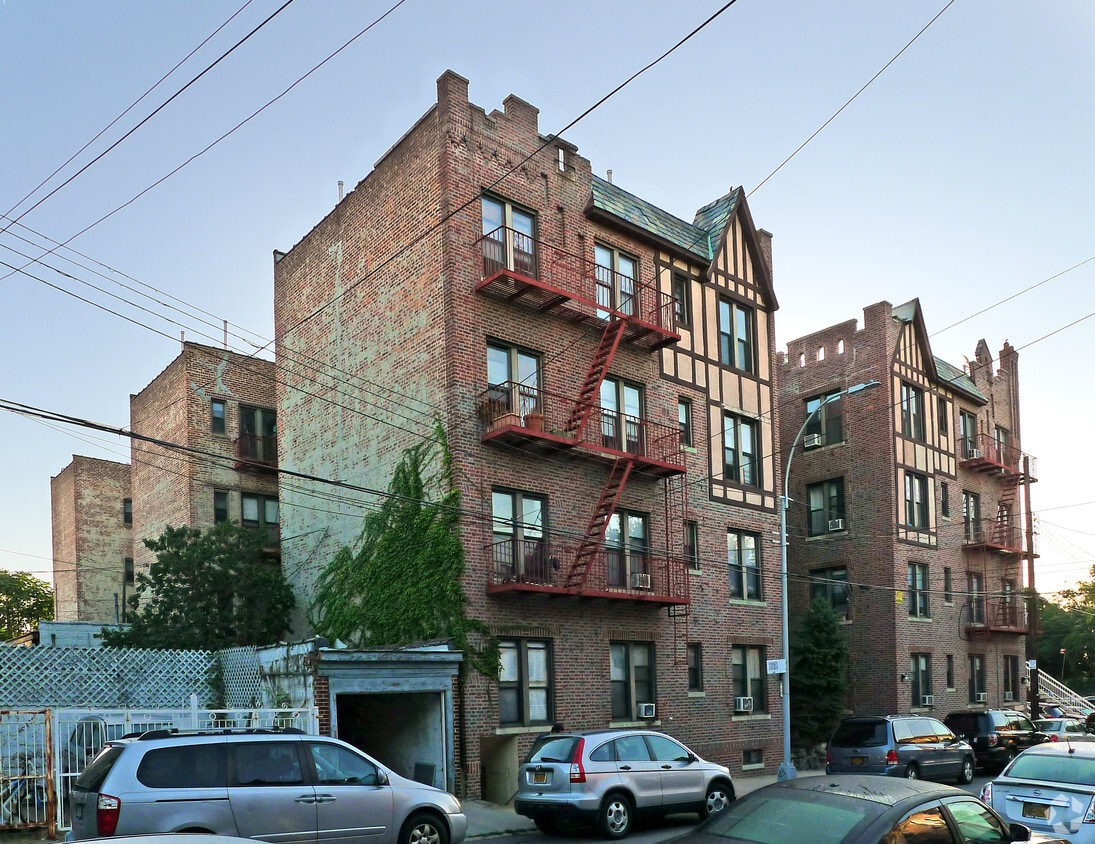
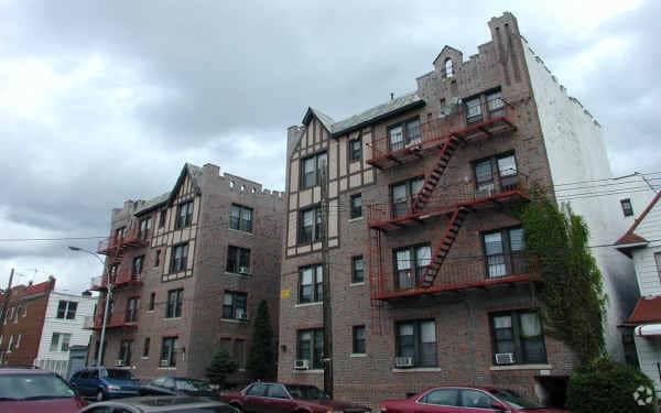
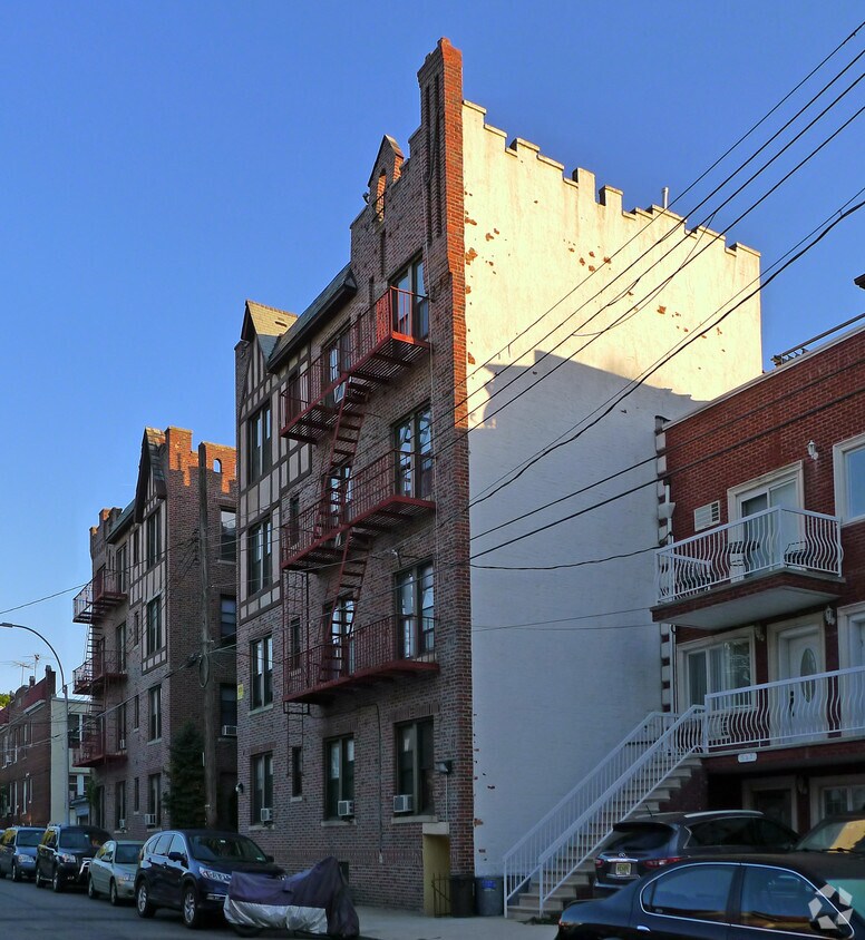

At 665 88th St in Brooklyn, NY, find your new home. The location in Brooklyn's 11228 area has so much to offer its residents. Make sure you to see the current floorplan options. From amenities to location, the leasing team is ready to help you in finding your perfect new apartment. Stop by to find out the current floorplan availability.
665 88th St is an apartment community located in Kings County and the 11228 ZIP Code. This area is served by the New York City Geographic District #20 attendance zone.
Controlled Access
Recycling
24 Hour Access
Trash Pickup - Curbside
Refrigerator
Disposal
Heating
Oven
Bay Ridge’s name can be taken quite literally, seeing as the neighborhood is situated on the ridge of New York’s Upper Bay in the bustling borough of Brooklyn. This urban, coastal oasis is known for its picturesque residential streets and slight seclusion from big city living.
Though Bay Ridge is an urban neighborhood, many residents applaud this coastal town for its ability to offer a suburban vibe and family-friendly atmosphere amidst its New York City location. Apartments, houses, condos, and townhomes range from cozy to luxury, so there’s something for everyone in this welcoming community.
Towering trees line the residential and commercial streets of Bay Ridge, giving it a park-like feel. And speaking of parks, this neighborhood’s entire coastline is covered by community parks featuring waterfront lawns, tall trees, and recreational amenities.
Learn more about living in Bay Ridge| Colleges & Universities | Distance | ||
|---|---|---|---|
| Colleges & Universities | Distance | ||
| Drive: | 12 min | 5.1 mi | |
| Drive: | 14 min | 6.0 mi | |
| Drive: | 14 min | 6.0 mi | |
| Drive: | 13 min | 6.8 mi |


Transportation options available in Brooklyn include 86 Street (R Line), located 0.6 mile from 665 88th St. 665 88th St is near Newark Liberty International, located 19.4 miles or 30 minutes away, and John F Kennedy International, located 19.6 miles or 29 minutes away.
| Transit / Subway | Distance | ||
|---|---|---|---|
| Transit / Subway | Distance | ||
|
|
Walk: | 11 min | 0.6 mi |
|
|
Walk: | 13 min | 0.7 mi |
|
|
Drive: | 2 min | 1.1 mi |
|
|
Drive: | 3 min | 1.5 mi |
|
|
Drive: | 5 min | 1.6 mi |
| Commuter Rail | Distance | ||
|---|---|---|---|
| Commuter Rail | Distance | ||
|
|
Drive: | 9 min | 4.3 mi |
|
|
Drive: | 9 min | 4.7 mi |
|
|
Drive: | 12 min | 5.4 mi |
|
|
Drive: | 14 min | 6.0 mi |
|
|
Drive: | 16 min | 6.6 mi |
| Airports | Distance | ||
|---|---|---|---|
| Airports | Distance | ||
|
Newark Liberty International
|
Drive: | 30 min | 19.4 mi |
|
John F Kennedy International
|
Drive: | 29 min | 19.6 mi |
Time and distance from 665 88th St.
| Shopping Centers | Distance | ||
|---|---|---|---|
| Shopping Centers | Distance | ||
| Walk: | 8 min | 0.4 mi | |
| Drive: | 3 min | 1.2 mi | |
| Drive: | 5 min | 2.2 mi |
| Parks and Recreation | Distance | ||
|---|---|---|---|
| Parks and Recreation | Distance | ||
|
Dyker Beach Park
|
Walk: | 9 min | 0.5 mi |
|
Owl's Head Park
|
Drive: | 6 min | 2.4 mi |
|
Narrows Botanical Gardens
|
Drive: | 7 min | 3.1 mi |
|
Gateway NRA - Staten Island Unit -Fort Wadsworth
|
Drive: | 7 min | 3.4 mi |
|
Alice Austen Park
|
Drive: | 9 min | 4.4 mi |
| Hospitals | Distance | ||
|---|---|---|---|
| Hospitals | Distance | ||
| Drive: | 5 min | 2.2 mi | |
| Drive: | 9 min | 4.8 mi | |
| Drive: | 11 min | 4.8 mi |
| Military Bases | Distance | ||
|---|---|---|---|
| Military Bases | Distance | ||
| Walk: | 13 min | 0.7 mi | |
| Drive: | 12 min | 5.6 mi |
What Are Walk Score®, Transit Score®, and Bike Score® Ratings?
Walk Score® measures the walkability of any address. Transit Score® measures access to public transit. Bike Score® measures the bikeability of any address.
What is a Sound Score Rating?
A Sound Score Rating aggregates noise caused by vehicle traffic, airplane traffic and local sources

665 88th St
Brooklyn, NY 11228


