
$1,695
/ Month
6610 Cat Creek Trail
Austin, TX 78731
2 Weeks Ago
Favorites
6610 Cat Creek Trail

Favorites
Check Back Soon for Upcoming Availability
| Beds | Baths | Average SF |
|---|---|---|
| 2 Bedrooms 2 Bedrooms 2 Br | 2 Baths 2 Baths 2 Ba | 1,190 SF |
About This Property
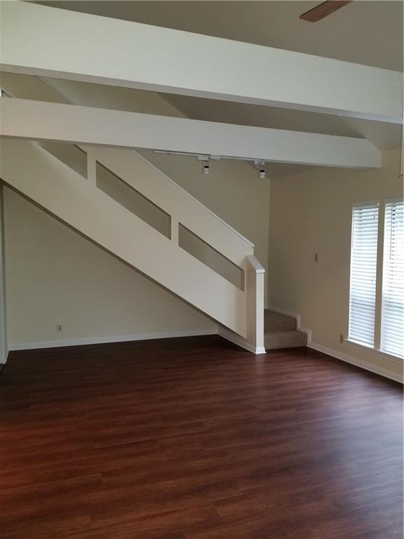
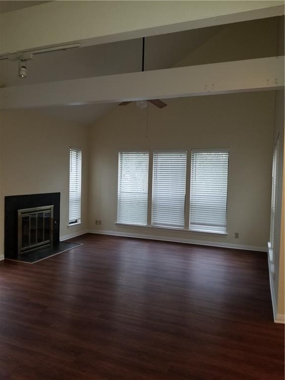
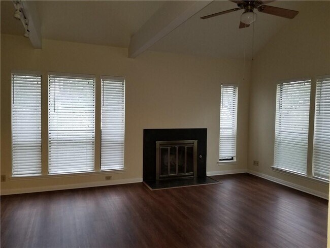
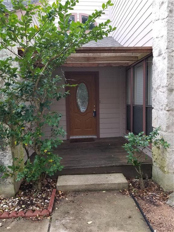
Your own treehouse. Tons of windows. High ceilings in living dining. one car garage. vinyl planking in living, tile in kitchen and bath, carpets in bedrooms. Cool spot in the northwest hills area, all natural habitat This is a duplex No yard for dog
6610 Cat Creek Trail is a townhome located in Travis County and the 78731 ZIP Code. This area is served by the Austin Independent attendance zone.
Location
Get Directions
Situated about seven miles northwest of Downtown Austin, Cat Mountain is a scenic neighborhood brimming with houses and apartments available for rent. Cat Mountain is mostly residential, lending the tree-dense community an overall peaceful atmosphere and laidback pace.
In addition to its residential calm, Cat Mountain offers residents lots of excitement in the form of outdoor recreation. The community is convenient to countless trails at Bull Creek District Park and Bright Leaf Preserve, as well as the picturesque Austin Country Club and endless possibilities for water-based recreation on the Colorado River.
Cat Mountain’s hilly landscape lends spectacular views of the Downtown Austin skyline in the east, along with the beautiful Texas Hill Country in the west. Cat Mountain is a popular choice for many renters, due to its close proximity to excellent schools, multiple highways, shopping centers, and major employers.
Learn more about living in Cat MountainBelow are rent ranges for similar nearby apartments
Education
| Colleges & Universities | Distance | ||
|---|---|---|---|
| Colleges & Universities | Distance | ||
| Drive: | 17 min | 8.4 mi | |
| Drive: | 15 min | 8.5 mi | |
| Drive: | 17 min | 8.5 mi | |
| Drive: | 18 min | 9.2 mi |
6610 Cat Creek Trail is within 17 minutes or 8.5 miles from Austin C.C., Northridge Campus. It is also near University of Texas at Austin and Austin C.C., Rio Grande Campus.
Schools


Public Elementary School
Grades PK-5
860 Students
Attendance Zone
Public Middle School
Grades 6-8
1,237 Students
Attendance Zone
Public High School
Grades 9-12
2,210 Students
Attendance Zone
Private Elementary & Middle School
Grades PK-8
430 Students
Nearby
Private Middle & High School
Grades 6-12
694 Students
Nearby
School data provided by
 The GreatSchools Rating helps parents compare schools within a state based on a variety of school quality indicators and provides a helpful picture of how effectively each school serves all of its students. Ratings are on a scale of 1 (below average) to 10 (above average) and can include test scores, college readiness, academic progress, advanced courses, equity, discipline and attendance data. We also advise parents to visit schools, consider other information on school performance and programs, and consider family needs as part of the school selection process.
View GreatSchools Rating Methodology
Data provided by GreatSchools.org © 2025. All rights reserved.
View GreatSchools Rating Methodology
Data provided by GreatSchools.org © 2025. All rights reserved.
Transportation options available in Austin include Crestview Station, located 5.9 miles from 6610 Cat Creek Trail. 6610 Cat Creek Trail is near Austin-Bergstrom International, located 19.4 miles or 38 minutes away.
| Transit / Subway | Distance | ||
|---|---|---|---|
| Transit / Subway | Distance | ||
| Drive: | 14 min | 5.9 mi | |
| Drive: | 15 min | 6.6 mi | |
| Drive: | 14 min | 6.9 mi | |
| Drive: | 16 min | 7.3 mi | |
| Drive: | 19 min | 9.6 mi |
| Commuter Rail | Distance | ||
|---|---|---|---|
| Commuter Rail | Distance | ||
|
|
Drive: | 17 min | 9.1 mi |
|
|
Drive: | 45 min | 34.0 mi |
|
|
Drive: | 53 min | 40.6 mi |
| Airports | Distance | ||
|---|---|---|---|
| Airports | Distance | ||
|
Austin-Bergstrom International
|
Drive: | 38 min | 19.4 mi |
Time and distance from 6610 Cat Creek Trail.
| Shopping Centers | Distance | ||
|---|---|---|---|
| Shopping Centers | Distance | ||
| Drive: | 5 min | 1.4 mi | |
| Drive: | 4 min | 1.6 mi | |
| Drive: | 6 min | 2.0 mi |
6610 Cat Creek Trail has 3 shopping centers within 2.0 miles, which is about a 6-minute drive. The miles and minutes will be for the farthest away property.
| Parks and Recreation | Distance | ||
|---|---|---|---|
| Parks and Recreation | Distance | ||
|
Bright Leaf Preserve
|
Drive: | 8 min | 3.0 mi |
|
Bull Creek Greenbelt
|
Drive: | 7 min | 3.0 mi |
|
Beverly S. Sheffield Northwest District Park
|
Drive: | 13 min | 4.8 mi |
|
The Stephen F. Austin Planetarium
|
Drive: | 13 min | 6.1 mi |
|
Mayfield Park and Preserve
|
Drive: | 12 min | 6.3 mi |
6610 Cat Creek Trail has 5 parks within 6.3 miles, including Bull Creek Greenbelt, Bright Leaf Preserve, and Beverly S. Sheffield Northwest District Park.
| Hospitals | Distance | ||
|---|---|---|---|
| Hospitals | Distance | ||
| Drive: | 7 min | 2.4 mi | |
| Drive: | 12 min | 5.6 mi | |
| Drive: | 12 min | 6.2 mi |
6610 Cat Creek Trail has 3 hospitals within 6.2 miles, the nearest is Northwest Hills Surgical Hospital which is 2.4 miles away and a 7 minute drive.
| Military Bases | Distance | ||
|---|---|---|---|
| Military Bases | Distance | ||
| Drive: | 92 min | 71.2 mi | |
| Drive: | 96 min | 75.6 mi |
6610 Cat Creek Trail is 71.2 miles from Fort Hood, and is convenient to other military bases, including Randolph Air Force Base.
You May Also Like
Similar Rentals Nearby


What Are Walk Score®, Transit Score®, and Bike Score® Ratings?
Walk Score® measures the walkability of any address. Transit Score® measures access to public transit. Bike Score® measures the bikeability of any address.
What is a Sound Score Rating?
A Sound Score Rating aggregates noise caused by vehicle traffic, airplane traffic and local sources
6610 Cat Creek Trail
Austin, TX 78731