
$2,700
/ Month
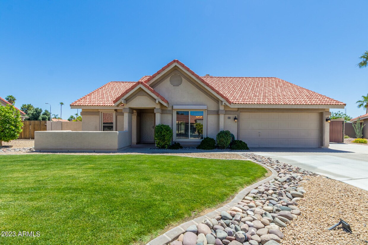
661 S Oak St Cir
Chandler, AZ 85226
Favorites
661 S Oak St Cir

Favorites
Check Back Soon for Upcoming Availability
| Beds | Baths | Average SF |
|---|---|---|
| 3 Bedrooms 3 Bedrooms 3 Br | 2 Baths 2 Baths 2 Ba | 1,608 SF |
About This Property
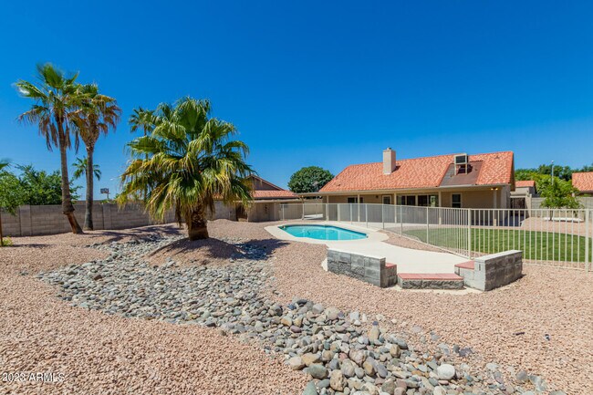
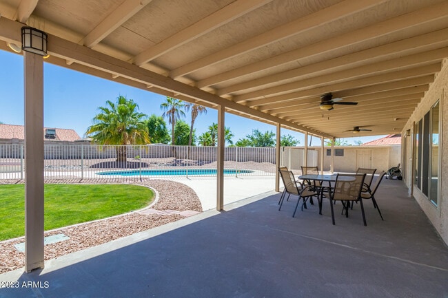
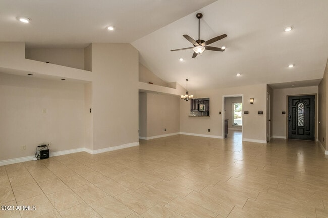
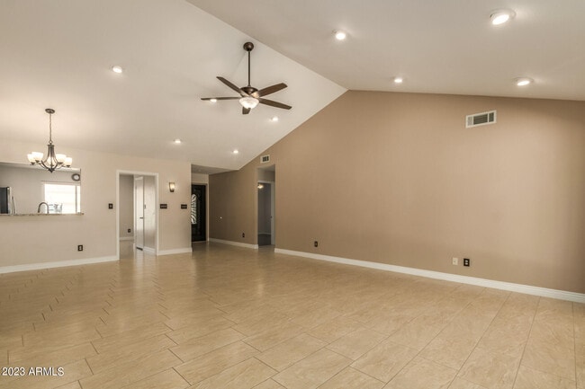
Sparkling pool!! Beautiful home on a large cul-de-sac lot. The Great room has Vaulted ceilings,ceiling fan & recessed lighting. Stunning oversized picture window looking out onto the crystal blue pool. Kitchen has high end stainless steel kitchen appliances. Gorgeous tile backsplash,granite countertops and undermount cabinet lighting. Space for a cozy breakfast table. Split floorplan. Updated baths. Tile and vinyl plank flooring. Entertainers will love this backyard. Huge covered patio with ceiling fans,fenced pool,RV gate and concrete slab behind gate with removable basketball hoop. Pomegranate & citrus trees. The lease includes pool service. Conveintly located near freeway for easy commute. Landlord will accept 1 small pet. Strong credit and income required
661 S Oak St Cir is a house located in Maricopa County and the 85226 ZIP Code. This area is served by the Kyrene Elementary School District attendance zone.
661 S Oak St Cir,
Chandler,
AZ
85226
Situated about four miles west of Downtown Chandler, West Chandler is a scenic suburb brimming with recreation and retail. West Chandler residents enjoy access to an array of local parks, including Desert Breeze Park, Nozomi Park, and Hanger Park, as well as close proximity to the sprawling South Mountain Park.
Retail options in West Chandler provide a host of modern delights and everyday conveniences, with numerous shopping centers and plazas strewn throughout the area in addition to the upscale Chandler Fashion Center. West Chandler is also convenient to the popular Lone Butte Casino. Getting around from West Chandler is easy with access to the Santan Freeway, Maricopa Freeway, and the Price Freeway.
Learn more about living in West ChandlerBelow are rent ranges for similar nearby apartments
| Beds | Average Size | Lowest | Typical | Premium |
|---|---|---|---|---|
| Studio Studio Studio | 528 Sq Ft | $1,095 | $1,866 | $3,856 |
| 1 Bed 1 Bed 1 Bed | 768 Sq Ft | $700 | $2,025 | $14,881 |
| 2 Beds 2 Beds 2 Beds | 1097 Sq Ft | $1,446 | $2,344 | $7,977 |
| 3 Beds 3 Beds 3 Beds | 1386 Sq Ft | $1,799 | $3,131 | $23,204 |
| 4 Beds 4 Beds 4 Beds | 2490 Sq Ft | $2,395 | $3,819 | $7,500 |
Education
| Colleges & Universities | Distance | ||
|---|---|---|---|
| Colleges & Universities | Distance | ||
| Drive: | 18 min | 10.8 mi | |
| Drive: | 18 min | 11.7 mi | |
| Drive: | 21 min | 12.0 mi | |
| Drive: | 19 min | 12.7 mi |
661 S Oak St Cir is within 18 minutes or 11.7 miles from Mesa C.C., Southern and Dobson. It is also near Chandler-Gilbert CC. Sun Lakes and Alverno College.
Schools


Public Elementary & Middle School
Grades K-8
565 Students
Attendance Zone
Public Elementary School
Grades PK-5
434 Students
Attendance Zone
Public High School
Grades 9-12
1,564 Students
Attendance Zone
Private Elementary & Middle School
Grades PK-8
357 Students
Nearby
Private Middle & High School
Grades 6-12
Nearby
School data provided by
 The GreatSchools Rating helps parents compare schools within a state based on a variety of school quality indicators and provides a helpful picture of how effectively each school serves all of its students. Ratings are on a scale of 1 (below average) to 10 (above average) and can include test scores, college readiness, academic progress, advanced courses, equity, discipline and attendance data. We also advise parents to visit schools, consider other information on school performance and programs, and consider family needs as part of the school selection process.
View GreatSchools Rating Methodology
Data provided by GreatSchools.org © 2026. All rights reserved.
View GreatSchools Rating Methodology
Data provided by GreatSchools.org © 2026. All rights reserved.
Transportation options available in Chandler include Rural/Apache, located 9.2 miles from 661 S Oak St Cir. 661 S Oak St Cir is near Phoenix Sky Harbor International, located 14.4 miles or 22 minutes away, and Phoenix-Mesa Gateway, located 18.2 miles or 27 minutes away.
| Transit / Subway | Distance | ||
|---|---|---|---|
| Transit / Subway | Distance | ||
|
|
Drive: | 18 min | 9.2 mi |
|
|
Drive: | 18 min | 9.3 mi |
|
|
Drive: | 19 min | 9.6 mi |
|
|
Drive: | 19 min | 13.3 mi |
|
|
Drive: | 20 min | 13.8 mi |
| Commuter Rail | Distance | ||
|---|---|---|---|
| Commuter Rail | Distance | ||
|
|
Drive: | 28 min | 20.1 mi |
| Airports | Distance | ||
|---|---|---|---|
| Airports | Distance | ||
|
Phoenix Sky Harbor International
|
Drive: | 22 min | 14.4 mi |
|
Phoenix-Mesa Gateway
|
Drive: | 27 min | 18.2 mi |
Walkability Near 661 S Oak St Cir Chandler, AZ 85226
Getting Around
 What do Walkability, Transit, Drivability, and Bikeability mean?
Walkability measures the walking distance to day-to-day needs.
Transit measures access to public transportation.
Drivability measures congestion, parking availability, and access to major roads.
Bikeability measures the suitability for cycling.
How It Works
What do Walkability, Transit, Drivability, and Bikeability mean?
Walkability measures the walking distance to day-to-day needs.
Transit measures access to public transportation.
Drivability measures congestion, parking availability, and access to major roads.
Bikeability measures the suitability for cycling.
How It Works
Somewhat Walkable
Walkability
30
/ 100
Minimal Public Transit
Transit
10
/ 100
Exceptionally Drivable
Drivability
100
/ 100
Fairly Bikeable
Bikeability
50
/ 100
Scores provided by
-
Soundscore™
-
/ 100
Traffic
-Airport
-Businesses
-Scores provided by
HowLoud What is a Sound Score Rating? A Sound Score Rating aggregates noise caused by vehicle traffic, airplane traffic and local sources. How It WorksTime and distance from 661 S Oak St Cir.
| Shopping Centers | Distance | ||
|---|---|---|---|
| Shopping Centers | Distance | ||
| Walk: | 19 min | 1.0 mi | |
| Walk: | 20 min | 1.1 mi | |
| Drive: | 3 min | 1.1 mi |
661 S Oak St Cir has 3 shopping centers within 1.1 miles, which is about a 3-minute drive. The miles and minutes will be for the farthest away property.
| Parks and Recreation | Distance | ||
|---|---|---|---|
| Parks and Recreation | Distance | ||
|
Pecos Park
|
Drive: | 9 min | 4.0 mi |
|
South Mountain Park
|
Drive: | 15 min | 8.1 mi |
|
ASU Center for Meteorite Studies
|
Drive: | 21 min | 10.1 mi |
|
Desert Arboretum Park
|
Drive: | 21 min | 10.3 mi |
|
Camelback Mountain Park
|
Drive: | 29 min | 16.1 mi |
661 S Oak St Cir has 5 parks within 16.1 miles, including Pecos Park, South Mountain Park, and ASU Center for Meteorite Studies.
| Hospitals | Distance | ||
|---|---|---|---|
| Hospitals | Distance | ||
| Drive: | 10 min | 5.6 mi | |
| Drive: | 11 min | 5.6 mi | |
| Drive: | 10 min | 6.8 mi |
661 S Oak St Cir has 3 hospitals within 6.8 miles, the nearest is Chandler Regional Medical Center which is 5.6 miles away and a 10 minute drive.
| Military Bases | Distance | ||
|---|---|---|---|
| Military Bases | Distance | ||
| Drive: | 21 min | 15.1 mi | |
| Drive: | 51 min | 39.4 mi | |
| Drive: | 97 min | 78.9 mi |
661 S Oak St Cir has 3 military bases within 78.9 miles, the nearest is Phoenix Sky Harbor Airport Air Guard Station which is 15.1 miles away and a 21 minute drive.
You May Also Like
Similar Rentals Nearby
-
-
-
1 / 73
 3 Beds$2,572+Total Monthly PriceTotal Monthly Price NewPrices include base rent and required monthly fees of $56. Variable costs based on usage may apply.Base Rent:3 Beds$2,515+2 Months Free
Pets Allowed Fitness Center Pool Dishwasher Refrigerator Kitchen
-
-
-
-
-
3 Beds$2,690+Total Monthly PriceTotal Monthly Price NewPrices include base rent and required monthly fees of $264. Variable costs based on usage may apply.Base Rent:3 Beds$2,425+2 Months Free
Pets Allowed Fitness Center Pool Dishwasher Walk-In Closets Stainless Steel Appliances
-
-


What Are Walk Score®, Transit Score®, and Bike Score® Ratings?
Walk Score® measures the walkability of any address. Transit Score® measures access to public transit. Bike Score® measures the bikeability of any address.
What is a Sound Score Rating?
A Sound Score Rating aggregates noise caused by vehicle traffic, airplane traffic and local sources.
661 S Oak St Cir
Chandler, AZ 85226