
Eighty Nine Dekalb
89 Dekalb Ave,
Brooklyn, NY 11201
$3,720 - $7,845
Studio - 2 Beds
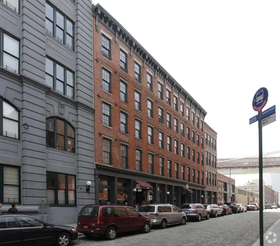
Just steps from Brooklyn’s premiere waterfront, 66 Water Street offers the quintessential DUMBO loft lifestyle. Think minimalist design and maximum impact. Fully redesigned interiors feature open floor plans with soaring ceilings and hardwood floors. Every residence boasts stainless steel kitchen appliances and granite countertops. Some have views of New York Harbor and Lower Manhattan.
66 Water Street is an apartment community located in Kings County and the 11201 ZIP Code. This area is served by the New York City Geographic District #13 attendance zone.
Sandwiched between the Brooklyn Bridge and the Manhattan Bridge, this tiny waterfront neighborhood began as an industrial area in the 19th century. Local lore says that when artists moved into the neglected Victorian factories in the late '70s, they dubbed the area Down Under Manhattan Bridge Overpass, or DUMBO, as counter-branding to thwart potential developers. Today, the renovated factories have transformed into apartments and lofts, many retaining original timber beams and red brick walls. In addition to the historic digs and cobblestone streets, residents list short commutes to Manhattan as a major draw, with 10-minute subway rides to the Lower East Side and 20-minute rides to Midtown.
Encircled by parks and bike paths, DUMBO offers grassy lawns and sweeping views of the East River. The area remains home to many art galleries, as well as St. Ann's Warehouse, a performing arts venue.
Learn more about living in DUMBO| Colleges & Universities | Distance | ||
|---|---|---|---|
| Colleges & Universities | Distance | ||
| Walk: | 12 min | 0.6 mi | |
| Drive: | 3 min | 1.1 mi | |
| Drive: | 3 min | 1.2 mi | |
| Drive: | 4 min | 1.4 mi |


Transportation options available in Brooklyn include York Street, located 0.3 mile from 66 Water Street. 66 Water Street is near LaGuardia, located 10.2 miles or 19 minutes away, and Newark Liberty International, located 14.5 miles or 25 minutes away.
| Transit / Subway | Distance | ||
|---|---|---|---|
| Transit / Subway | Distance | ||
|
|
Walk: | 6 min | 0.3 mi |
|
|
Walk: | 6 min | 0.4 mi |
|
|
Walk: | 11 min | 0.6 mi |
| Walk: | 15 min | 0.8 mi | |
|
|
Drive: | 3 min | 1.2 mi |
| Commuter Rail | Distance | ||
|---|---|---|---|
| Commuter Rail | Distance | ||
|
|
Drive: | 7 min | 2.4 mi |
|
|
Drive: | 11 min | 3.5 mi |
|
|
Drive: | 11 min | 3.6 mi |
|
|
Drive: | 12 min | 4.2 mi |
|
|
Drive: | 17 min | 6.3 mi |
| Airports | Distance | ||
|---|---|---|---|
| Airports | Distance | ||
|
LaGuardia
|
Drive: | 19 min | 10.2 mi |
|
Newark Liberty International
|
Drive: | 25 min | 14.5 mi |
Time and distance from 66 Water Street.
| Shopping Centers | Distance | ||
|---|---|---|---|
| Shopping Centers | Distance | ||
| Walk: | 15 min | 0.8 mi | |
| Drive: | 6 min | 2.3 mi |
| Parks and Recreation | Distance | ||
|---|---|---|---|
| Parks and Recreation | Distance | ||
|
Brooklyn Bridge Park
|
Walk: | 8 min | 0.4 mi |
|
Cadman Plaza Park
|
Walk: | 8 min | 0.5 mi |
|
Commodore Barry Park
|
Drive: | 4 min | 1.4 mi |
|
Cobble Hill Park
|
Drive: | 4 min | 1.6 mi |
|
City Hall Park
|
Drive: | 5 min | 2.0 mi |
| Hospitals | Distance | ||
|---|---|---|---|
| Hospitals | Distance | ||
| Drive: | 5 min | 1.8 mi | |
| Drive: | 8 min | 3.2 mi | |
| Drive: | 10 min | 4.0 mi |
| Military Bases | Distance | ||
|---|---|---|---|
| Military Bases | Distance | ||
| Drive: | 11 min | 4.3 mi | |
| Drive: | 23 min | 11.9 mi |
What Are Walk Score®, Transit Score®, and Bike Score® Ratings?
Walk Score® measures the walkability of any address. Transit Score® measures access to public transit. Bike Score® measures the bikeability of any address.
What is a Sound Score Rating?
A Sound Score Rating aggregates noise caused by vehicle traffic, airplane traffic and local sources

66 Water St
Brooklyn, NY 11201


