$2,400
/ Month
651 S 17th St
Newark, NJ 07103
Today
|
Edit
Favorites
973-739-8008
-
Bedrooms
3
-
Bathrooms
1
-
Square Feet
--
-
Available
Available Now
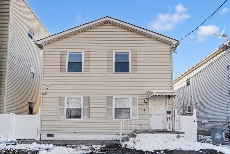
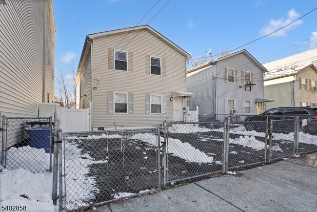
651 S 17th St

Favorites
About This Home
Available Now
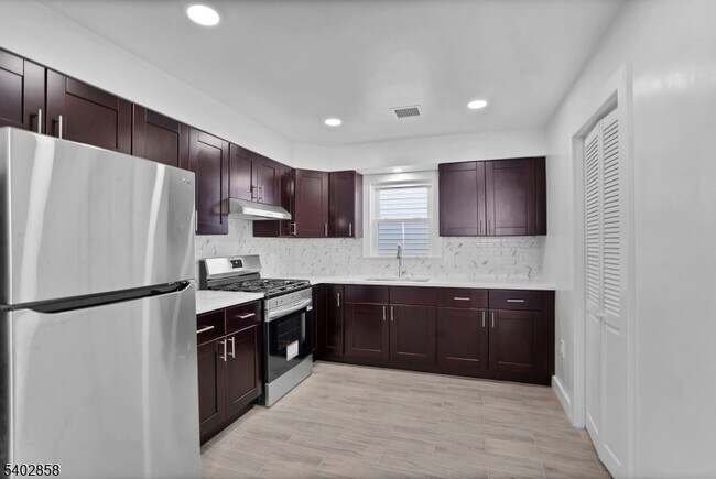
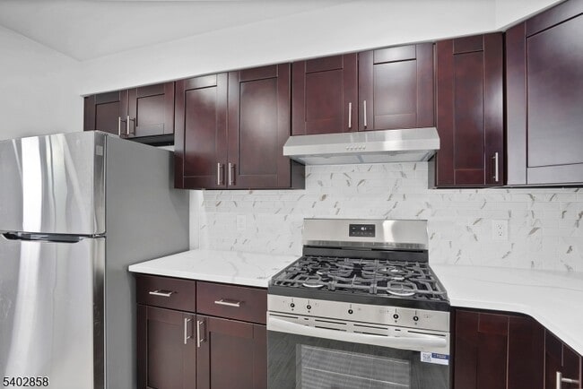
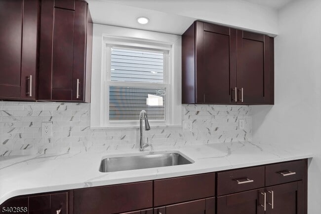
Newly Renovated 3-Bedroom Apartment West SideBeautifully renovated in 2025, this spacious 3-bedroom, 1-bath apartment is located in the desirable West Side section, off of Springfield Avenue, directly across from West Side Park.The apartment features a large living and dining area with brand-new finishes throughout. Enjoy central heating and air conditioning, washer and dryer hookups, and the convenience of one assigned parking space.Move-in ready with modern upgrades and an excellent location."
651 S 17Th St is an apartment community located in Essex County and the 07103 ZIP Code.
* Price shown is base rent. Excludes user-selected optional fees and variable or usage-based fees and required charges due at or prior to move-in or at move-out. Price, availability, fees, and any applicable rent special are subject to change without notice.
* Square footage definitions vary. Displayed square footage is approximate.
Features
- Air Conditioning
Contact
- Listed by LYANNE GIRALDO | GardenStateMLS#NJ
- Phone Number
- Contact
-
Source
Garden State Multiple Listing Service, LLC
Copyright © 2026 Garden State MLS, LLC. All rights reserved. All information provided by the listing agent/broker is deemed reliable but is not guaranteed and should be independently verified.
Location
Get Directions
The West Side of Newark is a well-established, urban community. Situated just west of downtown, the historic West Side County Park anchors the community and draws in locals for baseball and other recreation in the city’s Central Ward. Residents of this community enjoy plentiful public transportation, an array of amenities along Springfield Avenue, and various apartments and condos for rent. West Side is very pedestrian friendly, with many residents walking from place to place. Great public schools, universities, and neighborhood parks can be found around the West Side of Newark.
Learn more about living in West Side
Amenities
- Air Conditioning
Education
| Colleges & Universities | Distance | ||
|---|---|---|---|
| Colleges & Universities | Distance | ||
| Drive: | 4 min | 2.2 mi | |
| Drive: | 5 min | 2.3 mi | |
| Drive: | 5 min | 2.6 mi | |
| Drive: | 7 min | 2.7 mi |
651 S 17th St is within 4 minutes or 2.2 miles from Essex County College. It is also near N.J. Inst. of Technology and Rutgers, Newark Campus.
Transportation options available in Newark include Warren Street, located 2.2 miles from 651 S 17th St. 651 S 17th St is near Newark Liberty International, located 6.2 miles or 10 minutes away, and LaGuardia, located 25.5 miles or 45 minutes away.
| Transit / Subway | Distance | ||
|---|---|---|---|
| Transit / Subway | Distance | ||
|
|
Drive: | 4 min | 2.2 mi |
|
|
Drive: | 4 min | 2.2 mi |
|
|
Drive: | 4 min | 2.2 mi |
|
|
Drive: | 4 min | 2.4 mi |
|
|
Drive: | 5 min | 2.4 mi |
| Commuter Rail | Distance | ||
|---|---|---|---|
| Commuter Rail | Distance | ||
|
|
Drive: | 5 min | 2.6 mi |
|
|
Drive: | 5 min | 2.7 mi |
|
|
Drive: | 6 min | 2.9 mi |
|
|
Drive: | 6 min | 3.1 mi |
|
|
Drive: | 11 min | 4.6 mi |
| Airports | Distance | ||
|---|---|---|---|
| Airports | Distance | ||
|
Newark Liberty International
|
Drive: | 10 min | 6.2 mi |
|
LaGuardia
|
Drive: | 45 min | 25.5 mi |
Time and distance from 651 S 17th St.
| Shopping Centers | Distance | ||
|---|---|---|---|
| Shopping Centers | Distance | ||
| Walk: | 13 min | 0.7 mi | |
| Drive: | 2 min | 1.1 mi | |
| Drive: | 4 min | 1.3 mi |
651 S 17th St has 3 shopping centers within 1.3 miles, which is about a 4-minute drive. The miles and minutes will be for the farthest away property.
| Parks and Recreation | Distance | ||
|---|---|---|---|
| Parks and Recreation | Distance | ||
|
Newark Museum and Dreyfuss Planetarium
|
Drive: | 5 min | 2.5 mi |
|
Branch Brook Park
|
Drive: | 8 min | 4.0 mi |
|
Edison National Historic Site
|
Drive: | 11 min | 5.3 mi |
|
Kearny Marsh
|
Drive: | 12 min | 5.5 mi |
|
Turtle Back Zoo
|
Drive: | 14 min | 7.0 mi |
651 S 17th St has 5 parks within 7.0 miles, including Newark Museum and Dreyfuss Planetarium, Branch Brook Park, and Edison National Historic Site.
| Hospitals | Distance | ||
|---|---|---|---|
| Hospitals | Distance | ||
| Drive: | 3 min | 1.5 mi | |
| Drive: | 4 min | 2.1 mi | |
| Drive: | 5 min | 2.5 mi |
651 S 17th St has 3 hospitals within 2.5 miles, the nearest is The University Hospital which is 1.5 miles away and a 3 minute drive.
| Military Bases | Distance | ||
|---|---|---|---|
| Military Bases | Distance | ||
| Drive: | 16 min | 10.0 mi | |
| Drive: | 23 min | 12.5 mi | |
| Drive: | 32 min | 18.2 mi |
651 S 17th St has 3 military bases within 18.2 miles, the nearest is Military Ocean Terminal which is 10.0 miles away and a 16 minute drive.
You May Also Like
How do I access Social Services in New Jersey?
Statewide service is free, confidential, multilingual and always open. Three easy ways to reach Social Services in NJ: Dial 2-1-1; text your zip code to 898-211; or chat at https://www.nj211.org
Similar Rentals Nearby
-
-
-
-
1 / 19

-
-
-
-
-
-
1 / 22


What Are Walk Score®, Transit Score®, and Bike Score® Ratings?
Walk Score® measures the walkability of any address. Transit Score® measures access to public transit. Bike Score® measures the bikeability of any address.
What is a Sound Score Rating?
A Sound Score Rating aggregates noise caused by vehicle traffic, airplane traffic and local sources

651 S 17th St
Newark, NJ 07103