
$3,500
Total Monthly Price
63R Charter St
Boston, MA 02113
Favorites
63R Charter St

Favorites
Check Back Soon for Upcoming Availability
| Beds | Baths | Average SF |
|---|---|---|
| 2 Bedrooms 2 Bedrooms 2 Br | 1 Bath 1 Bath 1 Ba | — |
About This Property
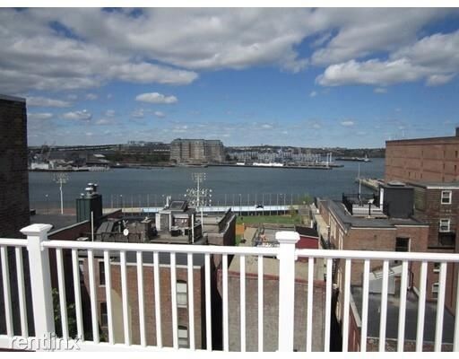
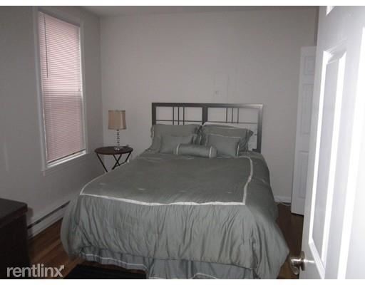
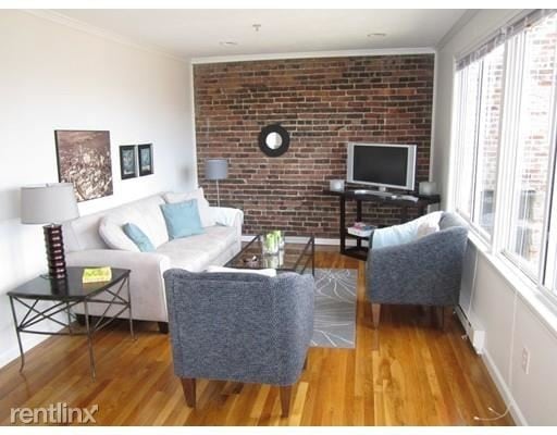
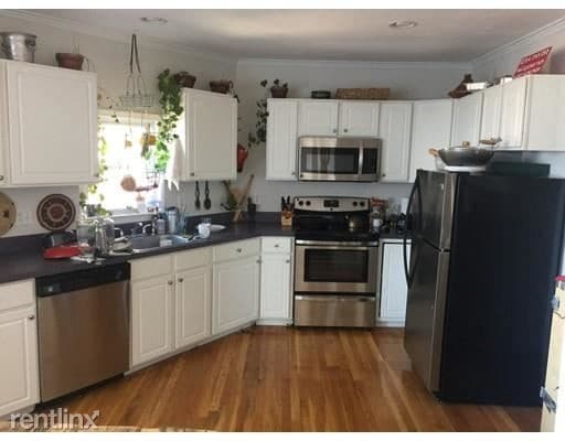
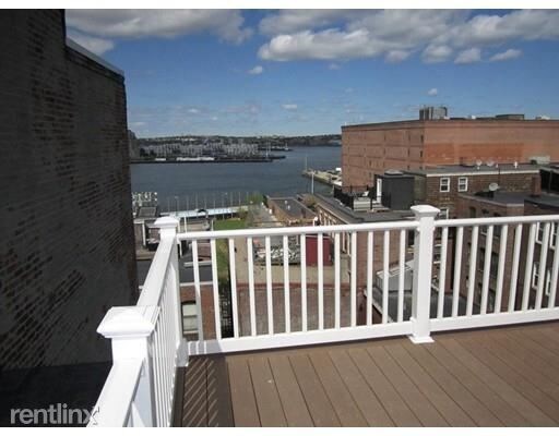
(774) 270-4020 - ****PENTHOUSE WITH PRIVATE DECK**** North End Two Bedroom Penthouse Duplex**** This Sunny penthouse is perched at one of the highest points in the North End. Two Large Bedrooms, Office area & Over sized kitchen and living room. Wall of windows offer an abundance of sunlight and unparalleled water views. NEW PRIVATE ROOF DECK WITH EXCELLENT HARBOR VIEWS. Laundry in the building and the property is professionally managed. (RLNE2709174) Other Amenities: Deck.
63R Charter St is a condo located in Suffolk County and the 02113 ZIP Code. This area is served by the Boston Public Schools attendance zone.
63R Charter St,
Boston,
MA
02113
The North End of Boston occupies the northeastern corner of the city beyond Washington Street and Columbus Circle. It is the city’s oldest residential neighborhood and comes with a rich history. Boston’s “Little Italy” has undergone some serious growth and modernization over the decades. Once home to revolutionary heroes such as Paul Revere, the area now draws new residents, young professionals, retirees, and tourists. Residents’ pride in this neighborhood is almost tangible – locals love North End and show it every summer during Feast season, a few weeks span of parades, music, dancing, and street food, all in celebration of North End and historic Italian Saints.
While this neighborhood is admittedly very tourist-heavy, the resulting revenue keeps the economy booming. Residents are still able to live, work, and play like normal. North End is less than a mile from Downtown Boston, making work commutes a breeze.
Learn more about living in North End BostonBelow are rent ranges for similar nearby apartments
| Beds | Average Size | Lowest | Typical | Premium |
|---|---|---|---|---|
| Studio Studio Studio | 3404 Sq Ft | $1,950 | $3,004 | $5,133 |
| 1 Bed 1 Bed 1 Bed | 3124 Sq Ft | $1,600 | $3,441 | $8,244 |
| 2 Beds 2 Beds 2 Beds | 3876 Sq Ft | $2,600 | $4,160 | $9,000 |
| 3 Beds 3 Beds 3 Beds | 4145 Sq Ft | $1,525 | $5,610 | $20,000 |
| 4 Beds 4 Beds 4 Beds | 3631 Sq Ft | $1,510 | $6,220 | $8,800 |
Education
| Colleges & Universities | Distance | ||
|---|---|---|---|
| Colleges & Universities | Distance | ||
| Walk: | 16 min | 0.8 mi | |
| Drive: | 5 min | 1.6 mi | |
| Drive: | 5 min | 2.0 mi | |
| Drive: | 5 min | 2.2 mi |
63R Charter St is within 16 minutes or 0.8 mile from Suffolk University. It is also near Bunker Hill Community College and Emerson College.
Schools


Public Elementary & Middle School
Grades PK-8
779 Students
Nearby
Public Middle & High School
Grades 6-12
646 Students
Nearby
Private Elementary & Middle School
Grades PK-8
224 Students
Nearby
Private High School
Grades 9-12
24 Students
Nearby
School data provided by
 The GreatSchools Rating helps parents compare schools within a state based on a variety of school quality indicators and provides a helpful picture of how effectively each school serves all of its students. Ratings are on a scale of 1 (below average) to 10 (above average) and can include test scores, college readiness, academic progress, advanced courses, equity, discipline and attendance data. We also advise parents to visit schools, consider other information on school performance and programs, and consider family needs as part of the school selection process.
View GreatSchools Rating Methodology
Data provided by GreatSchools.org © 2026. All rights reserved.
View GreatSchools Rating Methodology
Data provided by GreatSchools.org © 2026. All rights reserved.
Transportation options available in Boston include North Station, located 0.4 mile from 63R Charter St. 63R Charter St is near General Edward Lawrence Logan International, located 3.4 miles or 8 minutes away.
| Transit / Subway | Distance | ||
|---|---|---|---|
| Transit / Subway | Distance | ||
|
|
Walk: | 8 min | 0.4 mi |
|
|
Walk: | 8 min | 0.5 mi |
|
|
Walk: | 13 min | 0.7 mi |
|
|
Walk: | 13 min | 0.7 mi |
|
|
Walk: | 14 min | 0.7 mi |
| Commuter Rail | Distance | ||
|---|---|---|---|
| Commuter Rail | Distance | ||
|
|
Walk: | 10 min | 0.5 mi |
|
|
Drive: | 3 min | 1.6 mi |
|
|
Drive: | 9 min | 2.9 mi |
| Drive: | 7 min | 3.5 mi | |
|
|
Drive: | 11 min | 6.6 mi |
| Airports | Distance | ||
|---|---|---|---|
| Airports | Distance | ||
|
General Edward Lawrence Logan International
|
Drive: | 8 min | 3.4 mi |
Walkability Near 63R Charter St Boston, MA 02113
Getting Around
 What do Walkability, Transit, Drivability, and Bikeability mean?
Walkability measures the walking distance to day-to-day needs.
Transit measures access to public transportation.
Drivability measures congestion, parking availability, and access to major roads.
Bikeability measures the suitability for cycling.
How It Works
What do Walkability, Transit, Drivability, and Bikeability mean?
Walkability measures the walking distance to day-to-day needs.
Transit measures access to public transportation.
Drivability measures congestion, parking availability, and access to major roads.
Bikeability measures the suitability for cycling.
How It Works
Exceptionally Walkable
Walkability
100
/ 100
Exceptional Public Transit
Transit
100
/ 100
Fairly Drivable
Drivability
40
/ 100
Moderately Bikeable
Bikeability
70
/ 100
Scores provided by
Busy
Soundscore™
64
/ 100
Traffic
BusyAirport
BusyBusinesses
BusyScores provided by
HowLoud What is a Sound Score Rating? A Sound Score Rating aggregates noise caused by vehicle traffic, airplane traffic and local sources. How It WorksTime and distance from 63R Charter St.
| Shopping Centers | Distance | ||
|---|---|---|---|
| Shopping Centers | Distance | ||
| Walk: | 8 min | 0.4 mi | |
| Walk: | 11 min | 0.6 mi | |
| Walk: | 12 min | 0.7 mi |
63R Charter St has 3 shopping centers within 0.7 mile, which is about a 12-minute walk. The miles and minutes will be for the farthest away property.
| Parks and Recreation | Distance | ||
|---|---|---|---|
| Parks and Recreation | Distance | ||
|
Boston National Historical Park
|
Walk: | 11 min | 0.6 mi |
|
New England Aquarium
|
Drive: | 3 min | 1.2 mi |
|
Museum of Science
|
Drive: | 5 min | 1.3 mi |
|
Boston Harbor Islands National Recreation Area
|
Drive: | 3 min | 1.3 mi |
|
Boston African American National Historic Site
|
Drive: | 4 min | 1.3 mi |
63R Charter St has 5 parks within 1.3 miles, including Boston National Historical Park, New England Aquarium, and Boston African American National Historic Site.
| Hospitals | Distance | ||
|---|---|---|---|
| Hospitals | Distance | ||
| Walk: | 16 min | 0.9 mi | |
| Drive: | 3 min | 1.1 mi | |
| Drive: | 3 min | 1.2 mi |
63R Charter St has 3 hospitals within 1.2 miles, the nearest is Shriners Hospital for Children - Boston which is 0.9 mile away and a 16 minute walk.
| Military Bases | Distance | ||
|---|---|---|---|
| Military Bases | Distance | ||
| Drive: | 29 min | 15.8 mi | |
| Drive: | 30 min | 16.9 mi | |
| Drive: | 30 min | 18.2 mi |
63R Charter St has 3 military bases within 18.2 miles, the nearest is Hanscom Air Force Base which is 15.8 miles away and a 29 minute drive.
You May Also Like
Similar Rentals Nearby


What Are Walk Score®, Transit Score®, and Bike Score® Ratings?
Walk Score® measures the walkability of any address. Transit Score® measures access to public transit. Bike Score® measures the bikeability of any address.
What is a Sound Score Rating?
A Sound Score Rating aggregates noise caused by vehicle traffic, airplane traffic and local sources.
63R Charter St
Boston, MA 02113