$2,250 / Month
6102 Steep Cactus Trail
Austin, TX 78735
2 Weeks Ago
Favorites
6102 Steep Cactus Trail

Favorites
Check Back Soon for Upcoming Availability
| Beds | Baths | Average SF |
|---|---|---|
| 3 Bedrooms 3 Bedrooms 3 Br | 2.5 Baths 2.5 Baths 2.5 Ba | 1,628 SF |
Fees and Policies
The fees below are based on community-supplied data and may exclude additional fees and utilities.
- Dogs Allowed
-
Fees not specified
- Cats Allowed
-
Fees not specified
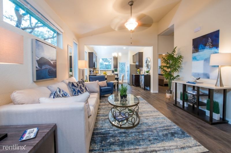
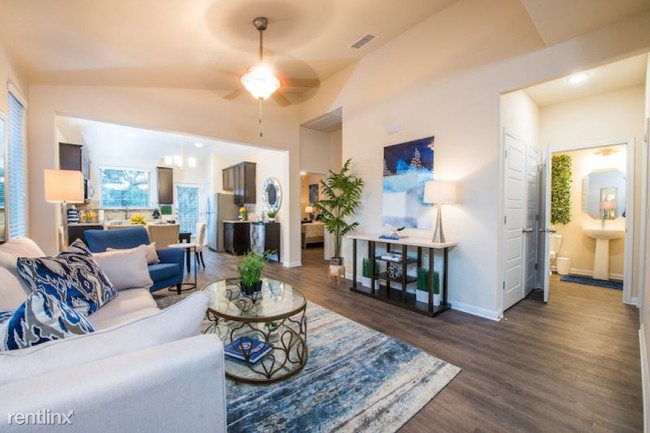
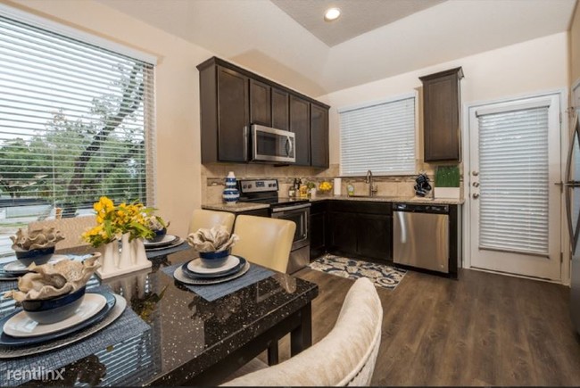
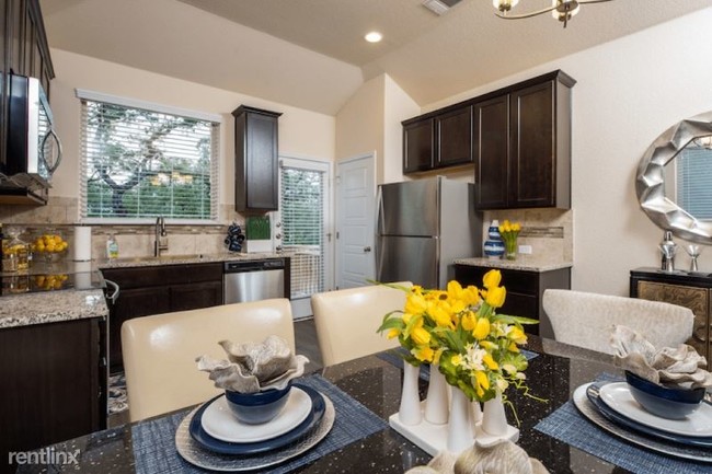
About This Property
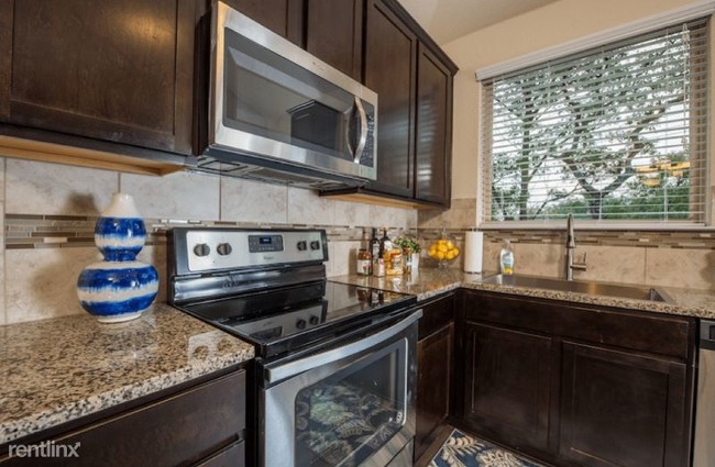
(512) 230-2174 - Excellent New 3 bed Townhouses in Bee Cave areas! - Property Id: 141352 -Granite countertops- -Stainless steel appliances- -Custom cabinets- -High ceilings- -Cultured marble- -Double vanities- -2 Car garage- -2 Walk-in closets- -Landscaped grounds- -Dog park- -Walking trails- -Close to 6 community parks and hike & bike trails- -Scott Petermann- -512-230-2174- -Citywide Realty LLC- Apply at TurboTenant: http://rental.turbotenant.com/properties/141352 Property Id 141352 (RLNE5538002) Other Amenities: Other (Cable Ready), Exercise Facility. Appliances: Dishwasher, Refrigerator, Range, Oven, Garbage Disposal, Washer & Dryer, Other (Freezer), Microwave. Lease lengths: 12 Months. Pet policies: Small Dogs Allowed, Cats Allowed, Large Dogs Allowed.
6102 Steep Cactus Trail is a townhome located in Travis County and the 78735 ZIP Code. This area is served by the Austin Independent attendance zone.
Unique Features
- Oven, Appliances - Freezer, Amenities - Cable Ready, Amenities - Cooling System: Central, Amenities
Townhome Features
- Washer/Dryer
- Dishwasher
Location
Get Directions
Just south of Barton Creek Habitat Preserves sits one Austin’s most family-friendly neighborhoods, West Oak Hill. Popular for its large lot sizes and relative tranquility when compared to the rest of the city that lies to the east, West Oak Hill is full of charming older houses, contemporary apartment homes, and plenty of amenities.
The nature preserve to the north is a notable feature, but there are also plenty of shopping centers on the neighborhood’s west side. Local restaurants of all types line Hwy 290 and TX-71, including popular spots like Jack Allen’s Kitchen Oak Hill. Take 290 to I-35 or up to the MoPac Expressway and you’ll be in Downtown Austin in just a few minutes. Commuters will appreciate the less intense traffic in West Oak Hills, and all the parks and green spaces that surround it.
Learn more about living in West Oak HillBelow are rent ranges for similar nearby apartments
| Beds | Average Size | Lowest | Typical | Premium |
|---|---|---|---|---|
| Studio Studio Studio | 528 Sq Ft | $1,334 | $1,693 | $2,398 |
| 1 Bed 1 Bed 1 Bed | 765-766 Sq Ft | $1,110 | $1,583 | $2,770 |
| 2 Beds 2 Beds 2 Beds | 1146 Sq Ft | $1,175 | $1,977 | $3,977 |
| 3 Beds 3 Beds 3 Beds | 1609 Sq Ft | $1,399 | $2,778 | $5,000 |
| 4 Beds 4 Beds 4 Beds | 3016 Sq Ft | $2,600 | $4,309 | $18,000 |
Amenities
- Washer/Dryer
- Dishwasher
- Oven, Appliances - Freezer, Amenities - Cable Ready, Amenities - Cooling System: Central, Amenities
Education
| Colleges & Universities | Distance | ||
|---|---|---|---|
| Colleges & Universities | Distance | ||
| Drive: | 5 min | 1.5 mi | |
| Drive: | 12 min | 5.5 mi | |
| Drive: | 14 min | 7.3 mi | |
| Drive: | 15 min | 9.0 mi |
6102 Steep Cactus Trail is within 5 minutes or 1.5 miles from Austin C.C., Pinnacle Campus. It is also near USAHS and Austin C.C., South Austin.
Schools


Public Elementary School
Grades PK-5
663 Students
Attendance Zone
Public Middle School
Grades 6-8
1,211 Students
Attendance Zone
Public High School
Grades 9-12
2,317 Students
Attendance Zone
Private Elementary, Middle & High School
Grades PK-12
Nearby
School data provided by
 The GreatSchools Rating helps parents compare schools within a state based on a variety of school quality indicators and provides a helpful picture of how effectively each school serves all of its students. Ratings are on a scale of 1 (below average) to 10 (above average) and can include test scores, college readiness, academic progress, advanced courses, equity, discipline and attendance data. We also advise parents to visit schools, consider other information on school performance and programs, and consider family needs as part of the school selection process.
View GreatSchools Rating Methodology
Data provided by GreatSchools.org © 2025. All rights reserved.
View GreatSchools Rating Methodology
Data provided by GreatSchools.org © 2025. All rights reserved.
Transportation options available in Austin include Downtown Station, located 10.6 miles from 6102 Steep Cactus Trail. 6102 Steep Cactus Trail is near Austin-Bergstrom International, located 16.6 miles or 31 minutes away.
| Transit / Subway | Distance | ||
|---|---|---|---|
| Transit / Subway | Distance | ||
| Drive: | 18 min | 10.6 mi | |
| Drive: | 20 min | 13.2 mi |
| Commuter Rail | Distance | ||
|---|---|---|---|
| Commuter Rail | Distance | ||
|
|
Drive: | 17 min | 9.8 mi |
|
|
Drive: | 45 min | 31.2 mi |
| Airports | Distance | ||
|---|---|---|---|
| Airports | Distance | ||
|
Austin-Bergstrom International
|
Drive: | 31 min | 16.6 mi |
Time and distance from 6102 Steep Cactus Trail.
| Shopping Centers | Distance | ||
|---|---|---|---|
| Shopping Centers | Distance | ||
| Walk: | 16 min | 0.8 mi | |
| Walk: | 18 min | 0.9 mi | |
| Drive: | 4 min | 1.5 mi |
6102 Steep Cactus Trail has 3 shopping centers within 1.5 miles, which is about a 4-minute walk. The miles and minutes will be for the farthest away property.
| Parks and Recreation | Distance | ||
|---|---|---|---|
| Parks and Recreation | Distance | ||
|
Dick Nichols Park
|
Drive: | 8 min | 3.5 mi |
|
Circle C Ranch Metropolitan Park
|
Drive: | 8 min | 3.9 mi |
|
Barton Creek Greenbelt (360 Access)
|
Drive: | 11 min | 6.0 mi |
|
Lady Bird Johnson Wildflower Center
|
Drive: | 14 min | 6.4 mi |
|
Goat Cave Nature Preserve
|
Drive: | 15 min | 6.9 mi |
6102 Steep Cactus Trail has 5 parks within 6.9 miles, including Dick Nichols Park, Circle C Ranch Metropolitan Park, and Lady Bird Johnson Wildflower Center.
| Hospitals | Distance | ||
|---|---|---|---|
| Hospitals | Distance | ||
| Drive: | 5 min | 2.0 mi | |
| Drive: | 14 min | 7.6 mi | |
| Drive: | 16 min | 7.9 mi |
6102 Steep Cactus Trail has 3 hospitals within 7.9 miles, the nearest is Ascension Seton Southwest which is 2.0 miles away and a 5 minute drive.
| Military Bases | Distance | ||
|---|---|---|---|
| Military Bases | Distance | ||
| Drive: | 87 min | 66.2 mi | |
| Drive: | 98 min | 75.9 mi |
6102 Steep Cactus Trail is 66.2 miles from Randolph Air Force Base, and is convenient to other military bases, including Camp Bullis Military Training Reservation.
You May Also Like
Similar Rentals Nearby
-
-
1 / 43

-
-
-
-
-
-
-
-


What Are Walk Score®, Transit Score®, and Bike Score® Ratings?
Walk Score® measures the walkability of any address. Transit Score® measures access to public transit. Bike Score® measures the bikeability of any address.
What is a Sound Score Rating?
A Sound Score Rating aggregates noise caused by vehicle traffic, airplane traffic and local sources

6102 Steep Cactus Trail
Austin, TX 78735