
$2,000
/ Month
61 Decatur St
Brooklyn, NY 11216
2 Weeks Ago
|
Edit
Favorites
61 Decatur St

Favorites
Check Back Soon for Upcoming Availability
| Beds | Baths | Average SF |
|---|---|---|
| 1 Bedroom 1 Bedroom 1 Br | 1 Bath 1 Bath 1 Ba | — |
About This Property
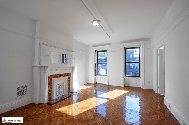
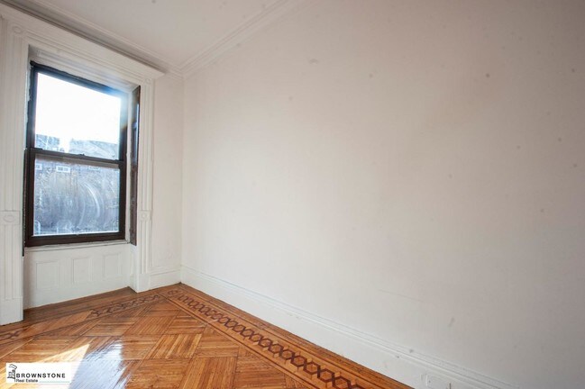
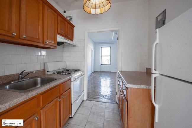
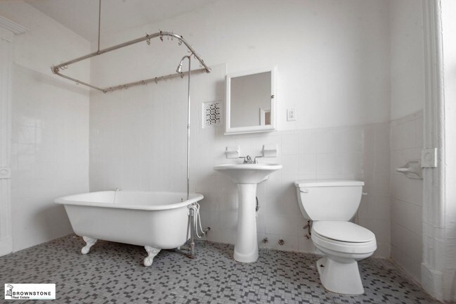
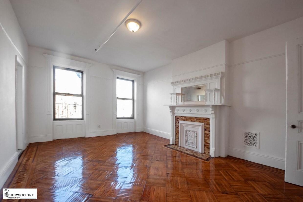
Huge one bedroom den floor through, open kitchen, dining room and full bath with tub. Gorgeous wood finishes and brownstone details everywhere. Beautiful wood floors.Heat hot water included
61 Decatur St is a townhome located in Kings County and the 11216 ZIP Code. This area is served by the New York City Special Schools - District 75 attendance zone.
Location
Get Directions
Bedford-Stuyvesant, often shortened to Bed-Stuy, sits in north central Brooklyn, touting plenty of classic brownstones along tree-lined streets. Bed-Stuy is revered for its historic architecture, containing one of the highest concentrations of Victorian properties in all of New York City.
Residents enjoy a strong sense of community in Bed-Stuy along with an array of diverse eateries, cafes, and bodegas. Herbert Von King Park lies at the center of the neighborhood, exuding a lively town-square atmosphere with an outdoor amphitheater, Cultural Arts Center, and athletic facilities. Convenience to public transportation and I-278 makes commuting and traveling from Bed-Stuy a breeze.
Learn more about living in Bedford-StuyvesantBelow are rent ranges for similar nearby apartments
| Beds | Average Size | Lowest | Typical | Premium |
|---|---|---|---|---|
| Studio Studio Studio | 532-546 Sq Ft | $1,013 | $2,878 | $5,500 |
| 1 Bed 1 Bed 1 Bed | 847 Sq Ft | $1,200 | $3,180 | $4,693 |
| 2 Beds 2 Beds 2 Beds | 999 Sq Ft | $1,450 | $3,658 | $12,950 |
| 3 Beds 3 Beds 3 Beds | 1164 Sq Ft | $1,125 | $2,607 | $15,000 |
| 4 Beds 4 Beds 4 Beds | 703 Sq Ft | $1,075 | $1,704 | $10,816 |
Education
| Colleges & Universities | Distance | ||
|---|---|---|---|
| Colleges & Universities | Distance | ||
| Drive: | 6 min | 1.9 mi | |
| Drive: | 6 min | 1.9 mi | |
| Drive: | 5 min | 2.1 mi | |
| Drive: | 6 min | 2.7 mi |
61 Decatur St is within 6 minutes or 1.9 miles from Medgar Evers College, CUNY. It is also near Pratt Institute and Saint Joseph's Coll, Brooklyn.
Schools


Public Elementary, Middle & High School
Grades K-10
318 Students
Nearby
Public Elementary School
Grades PK-5
119 Students
Attendance Zone
Public High School
Grades 9-12
403 Students
Attendance Zone
Private Elementary & Middle School
Grades PK-4 & 6-7
Nearby
Private Elementary, Middle & High School
Grades 1-12
Nearby
School data provided by
 The GreatSchools Rating helps parents compare schools within a state based on a variety of school quality indicators and provides a helpful picture of how effectively each school serves all of its students. Ratings are on a scale of 1 (below average) to 10 (above average) and can include test scores, college readiness, academic progress, advanced courses, equity, discipline and attendance data. We also advise parents to visit schools, consider other information on school performance and programs, and consider family needs as part of the school selection process.
View GreatSchools Rating Methodology
Data provided by GreatSchools.org © 2025. All rights reserved.
View GreatSchools Rating Methodology
Data provided by GreatSchools.org © 2025. All rights reserved.
Transportation options available in Brooklyn include Kingston-Throop Avenues, located 0.1 mile from 61 Decatur St. 61 Decatur St is near John F Kennedy International, located 10.6 miles or 22 minutes away, and LaGuardia, located 10.9 miles or 21 minutes away.
| Transit / Subway | Distance | ||
|---|---|---|---|
| Transit / Subway | Distance | ||
|
|
Walk: | 1 min | 0.1 mi |
|
|
Walk: | 9 min | 0.5 mi |
|
|
Walk: | 11 min | 0.6 mi |
|
|
Walk: | 15 min | 0.8 mi |
|
|
Drive: | 4 min | 1.2 mi |
| Commuter Rail | Distance | ||
|---|---|---|---|
| Commuter Rail | Distance | ||
|
|
Walk: | 10 min | 0.5 mi |
|
|
Drive: | 6 min | 2.2 mi |
|
|
Drive: | 6 min | 2.2 mi |
|
|
Drive: | 16 min | 6.6 mi |
|
|
Drive: | 16 min | 6.8 mi |
| Airports | Distance | ||
|---|---|---|---|
| Airports | Distance | ||
|
John F Kennedy International
|
Drive: | 22 min | 10.6 mi |
|
LaGuardia
|
Drive: | 21 min | 10.9 mi |
Time and distance from 61 Decatur St.
| Shopping Centers | Distance | ||
|---|---|---|---|
| Shopping Centers | Distance | ||
| Drive: | 6 min | 1.9 mi | |
| Drive: | 6 min | 2.3 mi |
61 Decatur St has 2 shopping centers within 2.3 miles, which is about a 6-minute drive. The miles and minutes will be for the farthest away property.
| Parks and Recreation | Distance | ||
|---|---|---|---|
| Parks and Recreation | Distance | ||
|
Brooklyn Children's Museum
|
Walk: | 10 min | 0.5 mi |
|
St. John's Park
|
Walk: | 14 min | 0.8 mi |
|
Crispus Attucks Playground
|
Drive: | 3 min | 1.1 mi |
|
Hattie Carthan Garden
|
Drive: | 5 min | 1.8 mi |
|
Brooklyn Botanic Garden
|
Drive: | 6 min | 2.5 mi |
61 Decatur St has 5 parks within 2.5 miles, including Brooklyn Children's Museum, St. John's Park, and Hattie Carthan Garden.
| Hospitals | Distance | ||
|---|---|---|---|
| Hospitals | Distance | ||
| Walk: | 7 min | 0.4 mi | |
| Drive: | 5 min | 1.6 mi | |
| Drive: | 7 min | 2.3 mi |
61 Decatur St has 3 hospitals within 2.3 miles, the nearest is Interfaith Medical Center which is 0.4 mile away and a 7 minute walk.
| Military Bases | Distance | ||
|---|---|---|---|
| Military Bases | Distance | ||
| Drive: | 18 min | 7.4 mi | |
| Drive: | 22 min | 9.2 mi |
61 Decatur St is 7.4 miles from Governors Island Support Center, and is convenient to other military bases, including Fort Hamilton.
You May Also Like
Similar Rentals Nearby


What Are Walk Score®, Transit Score®, and Bike Score® Ratings?
Walk Score® measures the walkability of any address. Transit Score® measures access to public transit. Bike Score® measures the bikeability of any address.
What is a Sound Score Rating?
A Sound Score Rating aggregates noise caused by vehicle traffic, airplane traffic and local sources
61 Decatur St
Brooklyn, NY 11216