
6 Manson Rd Unit 0
6 Manson Rd Unit 0
Needham, MA 02494
2 Weeks Ago
Favorites
6 Manson Rd Unit 0

Favorites
Check Back Soon for Upcoming Availability
| Beds | Baths | Average SF |
|---|---|---|
| 1 Bedroom 1 Bedroom 1 Br | 1 Bath 1 Bath 1 Ba | 650 SF |
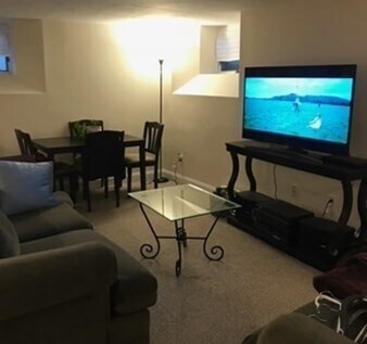
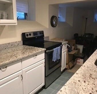
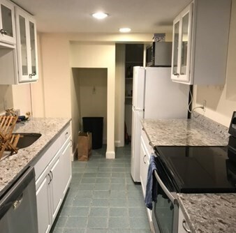
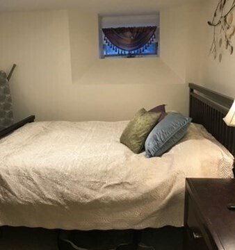
About This Property
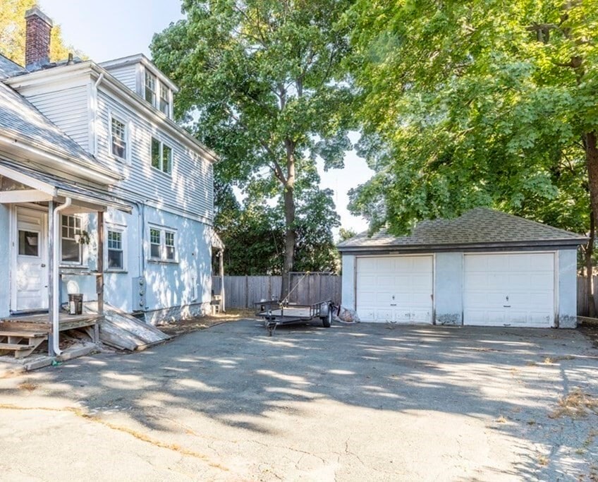
Introducing the epitome of convenient living at 6 Manson Rd,Needham,MA! Nestled in a serene neighborhood,this charming abode boasts a cozy 1 bedroom,1 bathroom layout complete with a convenient in-unit washer and dryer. Your rent includes a comprehensive package covering heat,hot water,electric,gas,water,sewer,and even snow removal,ensuring worry-free living all year round. With dedicated one parking spot off street. Don't miss out on this rare opportunity for effortless living in one of Needham's most coveted locations!
6 Manson Rd is an apartment community located in Norfolk County and the 02494 ZIP Code.
Location
Get Directions
Just west of Boston and East of Worcester sits Metro West, a region that houses a group of towns and cities with significant historical backgrounds. A total of 19 municipalities make up the core of this community, but other municipalities are considered to be a part of the Interstate 495/Metro West Corridor.
Learn more about living in Metro WestBelow are rent ranges for similar nearby apartments
| Beds | Average Size | Lowest | Typical | Premium |
|---|---|---|---|---|
| Studio Studio Studio | 615-617 Sq Ft | $1,125 | $2,213 | $3,630 |
| 1 Bed 1 Bed 1 Bed | 875-876 Sq Ft | $1,140 | $2,867 | $9,323 |
| 2 Beds 2 Beds 2 Beds | 1276-1277 Sq Ft | $1,800 | $3,612 | $17,713 |
| 3 Beds 3 Beds 3 Beds | 1573-1577 Sq Ft | $1,000 | $4,789 | $21,131 |
| 4 Beds 4 Beds 4 Beds | 3741 Sq Ft | $1,210 | $6,709 | $30,000 |
Education
| Colleges & Universities | Distance | ||
|---|---|---|---|
| Colleges & Universities | Distance | ||
| Drive: | 7 min | 3.4 mi | |
| Drive: | 12 min | 4.8 mi | |
| Drive: | 10 min | 5.3 mi | |
| Drive: | 11 min | 5.7 mi |
6 Manson Rd Unit 0 is within 7 minutes or 3.4 miles from Babson College. It is also near Wellesley College and Boston College.
Transportation options available in Needham include Newton Highlands Station, located 2.4 miles from 6 Manson Rd Unit 0. 6 Manson Rd Unit 0 is near General Edward Lawrence Logan International, located 15.5 miles or 27 minutes away, and Worcester Regional, located 42.1 miles or 60 minutes away.
| Transit / Subway | Distance | ||
|---|---|---|---|
| Transit / Subway | Distance | ||
|
|
Drive: | 4 min | 2.4 mi |
|
|
Drive: | 6 min | 2.6 mi |
|
|
Drive: | 6 min | 2.8 mi |
|
|
Drive: | 7 min | 4.0 mi |
|
|
Drive: | 7 min | 4.2 mi |
| Commuter Rail | Distance | ||
|---|---|---|---|
| Commuter Rail | Distance | ||
|
|
Walk: | 7 min | 0.4 mi |
|
|
Drive: | 2 min | 1.3 mi |
|
|
Drive: | 4 min | 1.8 mi |
|
|
Drive: | 5 min | 2.6 mi |
|
|
Drive: | 7 min | 3.3 mi |
| Airports | Distance | ||
|---|---|---|---|
| Airports | Distance | ||
|
General Edward Lawrence Logan International
|
Drive: | 27 min | 15.5 mi |
|
Worcester Regional
|
Drive: | 60 min | 42.1 mi |
Time and distance from 6 Manson Rd Unit 0.
| Shopping Centers | Distance | ||
|---|---|---|---|
| Shopping Centers | Distance | ||
| Walk: | 15 min | 0.8 mi | |
| Walk: | 19 min | 1.0 mi | |
| Drive: | 2 min | 1.3 mi |
6 Manson Rd Unit 0 has 3 shopping centers within 1.3 miles, which is about a 2-minute walk. The miles and minutes will be for the farthest away property.
| Parks and Recreation | Distance | ||
|---|---|---|---|
| Parks and Recreation | Distance | ||
|
Cutler Park Reservation
|
Drive: | 3 min | 1.5 mi |
|
Hemlock Gorge Reservation
|
Drive: | 3 min | 1.6 mi |
|
Hammond Pond Reservation
|
Drive: | 7 min | 4.1 mi |
|
Whitin Observatory
|
Drive: | 10 min | 4.3 mi |
|
Brook Farm Historic Site
|
Drive: | 8 min | 4.3 mi |
6 Manson Rd Unit 0 has 5 parks within 4.3 miles, including Cutler Park Reservation, Hemlock Gorge Reservation, and Hammond Pond Reservation.
| Hospitals | Distance | ||
|---|---|---|---|
| Hospitals | Distance | ||
| Drive: | 2 min | 1.4 mi | |
| Drive: | 6 min | 3.8 mi | |
| Drive: | 10 min | 5.3 mi |
6 Manson Rd Unit 0 has 3 hospitals within 5.3 miles, the nearest is Beth Israel Deaconess Hospital - Needham which is 1.4 miles away and a 2 minute drive.
| Military Bases | Distance | ||
|---|---|---|---|
| Military Bases | Distance | ||
| Drive: | 15 min | 7.4 mi | |
| Drive: | 23 min | 13.7 mi |
6 Manson Rd Unit 0 is 7.4 miles from US Military Reservation, and is convenient to other military bases, including Hanscom Air Force Base.
You May Also Like
-
Harbor Point
24 Oyster Bay Rd
Boston, MA 02125
$2,033 - $4,800 Plus Fees
1-3 Br 10.0 mi
-
Waterfall Hills at Canton
55 Waterfall Dr
Canton, MA 02021
$2,665 - $3,465 Plus Fees
1-2 Br 12 Month Lease 11.5 mi
-
Elevation Apartments at Crown Colony
7 Crown Dr
Quincy, MA 02169
$2,475 - $3,300 Plus Fees
1-2 Br 12 Month Lease 12.2 mi
Similar Rentals Nearby


What Are Walk Score®, Transit Score®, and Bike Score® Ratings?
Walk Score® measures the walkability of any address. Transit Score® measures access to public transit. Bike Score® measures the bikeability of any address.
What is a Sound Score Rating?
A Sound Score Rating aggregates noise caused by vehicle traffic, airplane traffic and local sources
6 Manson Rd
Needham, MA 02494