
$3,500
/ Month
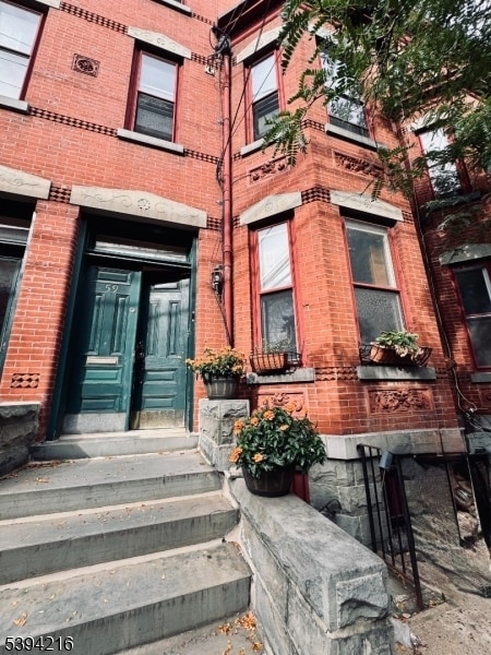
59 James St
Newark, NJ 07102
Today
|
Edit
Favorites
973-746-4777
-
Bedrooms
2
-
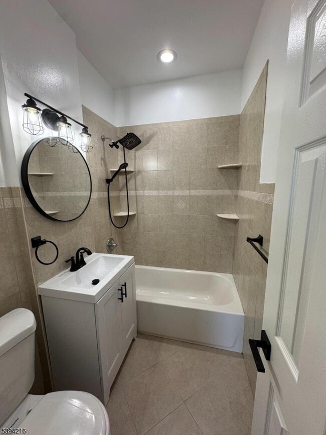
Bathrooms
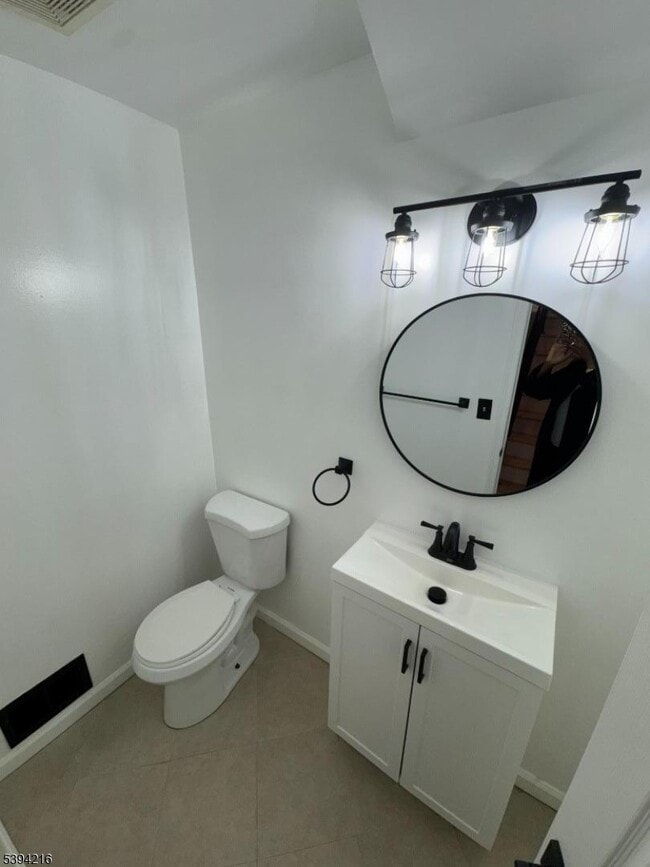
2.5
-
Square Feet
1,300 sq ft
-
Available
Available Now
Highlights
- Deck
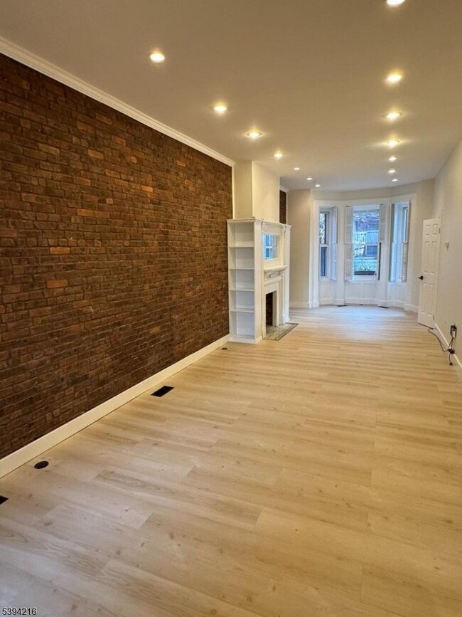
- Living Room with Fireplace
- Wood Flooring
- 2 Fireplaces
- Laundry Room
- Stone Flooring
59 James St

Favorites
59 James St is a townhome located in Essex County and the 07102 ZIP Code. This area is served by the The Newark Public attendance zone.
* Price shown is base rent. Excludes user-selected optional fees and variable or usage-based fees and required charges due at or prior to move-in or at move-out. Price, availability, fees, and any applicable rent special are subject to change without notice.
* Square footage definitions vary. Displayed square footage is approximate.
Home Details
Home Type
Interior Unit Townhome
Year Built
Built in 1860 | Remodeled
Bedrooms and Bathrooms
Primary bedroom located on second floor
Powder Room
2.5 Bathrooms
2 Bedrooms
Flooring
Wood
Stone
Home Security
Fire and Smoke Detector
Interior Spaces
Living Room with Fireplace
2 Fireplaces
1,300 Sq Ft Home
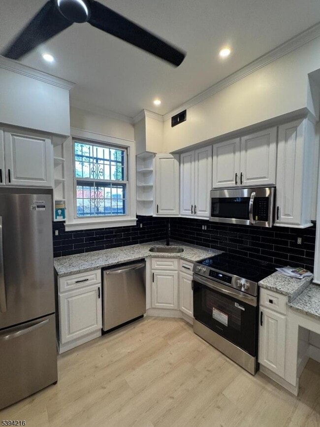
Kitchen
Gas Oven or Range
Microwave
Dishwasher
Laundry
Laundry Room
Listing and Financial Details
Assessor Parcel Number 1614-00045-0000-00041-0001-
Tenant pays for electric, gas, heat, hot water, repair insurance, water
Lot Details
1,742 Sq Ft Lot
Outdoor Features
Deck
Parking
Parking Lot
Shared Driveway
Common or Shared Parking
1 Parking Space
Utilities
Forced Air Heating and Cooling System
Gas Water Heater
Standard Electricity
One Cooling System Mounted To A Wall/Window
Community Details
Contact
- Listed by TAMMY MACK | GardenStateMLS#NJ
- Phone Number
-
Source
Garden State Multiple Listing Service, LLC
Copyright © 2025 Garden State MLS, LLC. All rights reserved. All information provided by the listing agent/broker is deemed reliable but is not guaranteed and should be independently verified.
Location
Get Directions
Amenities
- Air Conditioning
- Dishwasher
- Microwave
- Range
- Hardwood Floors
- Deck
As its name implies, University Heights houses several academic institutions. University Heights is home to Essex County College, the New Jersey Institute of Technology, and Rutgers University-Newark Campus. Sprawling campuses, along with several medical facilities like Saint Michael's Medical Center and Rutger’s University Hospital, dominate the neighborhood but there still plenty of rentals to choose from. Ideal for all renters, University Heights has affordable to upscale rentals available.
This urban neighborhood is nestled beside Downtown Newark, giving easy access to some of the city’s best dining, shopping, and entertainment options. Bike lanes and a light rail system provide transportation options that make it easy to get around, although you may opt to simply lace up your shoes in this walkable neighborhood. Locals enjoy being able to stroll downtown entertainment hubs like the New Jersey Performing Arts Center and Prudential Center.
Learn more about living in University Heights
Education
| Colleges & Universities | Distance | ||
|---|---|---|---|
| Colleges & Universities | Distance | ||
| Walk: | 4 min | 0.2 mi | |
| Walk: | 9 min | 0.5 mi | |
| Walk: | 12 min | 0.6 mi | |
| Drive: | 8 min | 4.2 mi |
59 James St is within 4 minutes or 0.2 mile from Rutgers, Newark Campus. It is also near N.J. Inst. of Technology and Essex County College.
Schools


Public Elementary & Middle School
Grades PK-8
513 Students
Attendance Zone
Public High School
Grades 9-12
1,734 Students
Attendance Zone
Public High School
Grades 9-12
665 Students
Attendance Zone
Private Elementary & Middle School
Grades K-8
36 Students
Nearby
Private Elementary School
Grades PK-4
Nearby
Private High School
Grades 9-12
Nearby
School data provided by
 The GreatSchools Rating helps parents compare schools within a state based on a variety of school quality indicators and provides a helpful picture of how effectively each school serves all of its students. Ratings are on a scale of 1 (below average) to 10 (above average) and can include test scores, college readiness, academic progress, advanced courses, equity, discipline and attendance data. We also advise parents to visit schools, consider other information on school performance and programs, and consider family needs as part of the school selection process.
View GreatSchools Rating Methodology
Data provided by GreatSchools.org © 2025. All rights reserved.
View GreatSchools Rating Methodology
Data provided by GreatSchools.org © 2025. All rights reserved.
Transportation options available in Newark include Newark-Broad Street, located 0.2 mile from 59 James St. 59 James St is near Newark Liberty International, located 6.1 miles or 10 minutes away, and LaGuardia, located 26.8 miles or 41 minutes away.
| Transit / Subway | Distance | ||
|---|---|---|---|
| Transit / Subway | Distance | ||
|
|
Walk: | 4 min | 0.2 mi |
|
|
Walk: | 4 min | 0.2 mi |
|
|
Walk: | 5 min | 0.3 mi |
|
|
Walk: | 6 min | 0.3 mi |
|
|
Walk: | 11 min | 0.6 mi |
| Commuter Rail | Distance | ||
|---|---|---|---|
| Commuter Rail | Distance | ||
|
|
Walk: | 6 min | 0.3 mi |
|
|
Drive: | 3 min | 1.4 mi |
|
|
Drive: | 4 min | 1.7 mi |
|
|
Drive: | 4 min | 2.3 mi |
|
|
Drive: | 5 min | 2.9 mi |
| Airports | Distance | ||
|---|---|---|---|
| Airports | Distance | ||
|
Newark Liberty International
|
Drive: | 10 min | 6.1 mi |
|
LaGuardia
|
Drive: | 41 min | 26.8 mi |
Time and distance from 59 James St.
| Shopping Centers | Distance | ||
|---|---|---|---|
| Shopping Centers | Distance | ||
| Walk: | 10 min | 0.5 mi | |
| Drive: | 3 min | 1.2 mi | |
| Drive: | 3 min | 1.3 mi |
59 James St has 3 shopping centers within 1.3 miles, which is about a 3-minute drive. The miles and minutes will be for the farthest away property.
| Parks and Recreation | Distance | ||
|---|---|---|---|
| Parks and Recreation | Distance | ||
|
Newark Museum and Dreyfuss Planetarium
|
Walk: | 4 min | 0.2 mi |
|
Branch Brook Park
|
Drive: | 5 min | 2.1 mi |
|
Kearny Marsh
|
Drive: | 8 min | 3.4 mi |
|
Edison National Historic Site
|
Drive: | 10 min | 5.2 mi |
|
Richard W. DeKorte Park
|
Drive: | 12 min | 5.9 mi |
59 James St has 5 parks within 5.9 miles, including Newark Museum and Dreyfuss Planetarium, Branch Brook Park, and Kearny Marsh.
| Hospitals | Distance | ||
|---|---|---|---|
| Hospitals | Distance | ||
| Walk: | 4 min | 0.2 mi | |
| Drive: | 3 min | 1.4 mi | |
| Drive: | 4 min | 2.3 mi |
59 James St has 3 hospitals within 2.3 miles, the nearest is Saint Michael's Medical Center which is 0.2 mile away and a 4 minute walk.
| Military Bases | Distance | ||
|---|---|---|---|
| Military Bases | Distance | ||
| Drive: | 16 min | 9.9 mi | |
| Drive: | 26 min | 12.5 mi | |
| Drive: | 31 min | 18.0 mi |
59 James St has 3 military bases within 18.0 miles, the nearest is Military Ocean Terminal which is 9.9 miles away and a 16 minute drive.
You May Also Like
How do I access Social Services in New Jersey?
Statewide service is free, confidential, multilingual and always open. Three easy ways to reach Social Services in NJ: Dial 2-1-1; text your zip code to 898-211; or chat at https://www.nj211.org
Similar Rentals Nearby


What Are Walk Score®, Transit Score®, and Bike Score® Ratings?
Walk Score® measures the walkability of any address. Transit Score® measures access to public transit. Bike Score® measures the bikeability of any address.
What is a Sound Score Rating?
A Sound Score Rating aggregates noise caused by vehicle traffic, airplane traffic and local sources

59 James St
Newark, NJ 07102