$2,600
/ Month
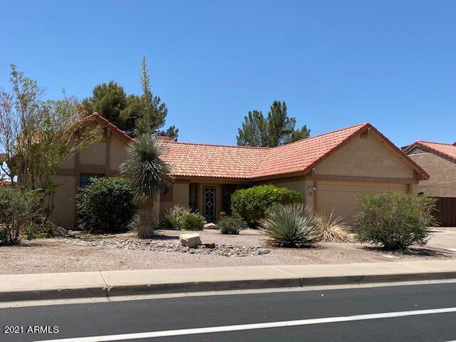
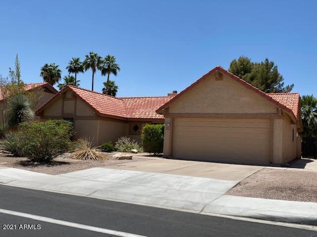
5629 W Frye Rd
Chandler, AZ 85226
2 Weeks Ago
|
Edit
Favorites
5629 W Frye Rd

Favorites
Check Back Soon for Upcoming Availability
| Beds | Baths | Average SF |
|---|---|---|
| 3 Bedrooms 3 Bedrooms 3 Br | 2 Baths 2 Baths 2 Ba | — |
About This Property
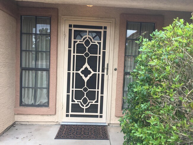
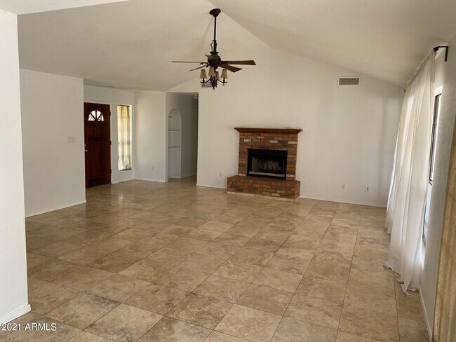
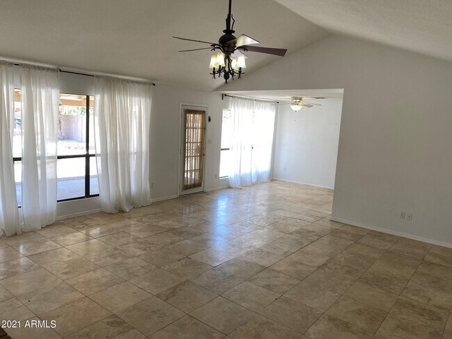
ACCEPTED APPLICATION. Cute 3bd/2bth home in the desirable Carrington Place community of Chandler. Featuring Travertine tile, wood floors, vaulted ceilings, new kitchen cabinets, granite kitchen counters, stainless steel appliances, new stove, new microwave, updated bathrooms, fireplace, and ceiling fans throughout. The low-maintenance backyard features a sparkling pool, spa, putting green, and an extended patio. Close to the malls, freeways and schools!
5629 W Frye Rd is a house located in Maricopa County and the 85226 ZIP Code. This area is served by the Kyrene Elementary attendance zone.
Location
Get Directions
Situated about four miles west of Downtown Chandler, West Chandler is a scenic suburb brimming with recreation and retail. West Chandler residents enjoy access to an array of local parks, including Desert Breeze Park, Nozomi Park, and Hanger Park, as well as close proximity to the sprawling South Mountain Park.
Retail options in West Chandler provide a host of modern delights and everyday conveniences, with numerous shopping centers and plazas strewn throughout the area in addition to the upscale Chandler Fashion Center. West Chandler is also convenient to the popular Lone Butte Casino. Getting around from West Chandler is easy with access to the Santan Freeway, Maricopa Freeway, and the Price Freeway.
Learn more about living in West ChandlerBelow are rent ranges for similar nearby apartments
Education
| Colleges & Universities | Distance | ||
|---|---|---|---|
| Colleges & Universities | Distance | ||
| Drive: | 17 min | 10.7 mi | |
| Drive: | 17 min | 11.5 mi | |
| Drive: | 20 min | 11.9 mi | |
| Drive: | 18 min | 12.5 mi |
5629 W Frye Rd is within 17 minutes or 11.5 miles from Mesa C.C., Southern and Dobson. It is also near Chandler-Gilbert CC. Sun Lakes and South Mountain Comm. Coll..
Schools


Public Elementary & Middle School
Grades 5-8
615 Students
Attendance Zone
Public Elementary School
Grades PK-5
487 Students
Attendance Zone
Public High School
Grades 9-12
1,716 Students
Attendance Zone
Private Elementary & Middle School
Grades PK-8
332 Students
Nearby
Private Middle & High School
Grades 6-12
Nearby
School data provided by
 The GreatSchools Rating helps parents compare schools within a state based on a variety of school quality indicators and provides a helpful picture of how effectively each school serves all of its students. Ratings are on a scale of 1 (below average) to 10 (above average) and can include test scores, college readiness, academic progress, advanced courses, equity, discipline and attendance data. We also advise parents to visit schools, consider other information on school performance and programs, and consider family needs as part of the school selection process.
View GreatSchools Rating Methodology
Data provided by GreatSchools.org © 2025. All rights reserved.
View GreatSchools Rating Methodology
Data provided by GreatSchools.org © 2025. All rights reserved.
Transportation options available in Chandler include Rural/Apache, located 9.1 miles from 5629 W Frye Rd. 5629 W Frye Rd is near Phoenix Sky Harbor International, located 14.2 miles or 22 minutes away, and Phoenix-Mesa Gateway, located 18.1 miles or 26 minutes away.
| Transit / Subway | Distance | ||
|---|---|---|---|
| Transit / Subway | Distance | ||
|
|
Drive: | 18 min | 9.1 mi |
|
|
Drive: | 17 min | 9.2 mi |
|
|
Drive: | 18 min | 9.5 mi |
|
|
Drive: | 18 min | 13.1 mi |
|
|
Drive: | 19 min | 13.6 mi |
| Commuter Rail | Distance | ||
|---|---|---|---|
| Commuter Rail | Distance | ||
|
|
Drive: | 28 min | 19.9 mi |
| Airports | Distance | ||
|---|---|---|---|
| Airports | Distance | ||
|
Phoenix Sky Harbor International
|
Drive: | 22 min | 14.2 mi |
|
Phoenix-Mesa Gateway
|
Drive: | 26 min | 18.1 mi |
Time and distance from 5629 W Frye Rd.
| Shopping Centers | Distance | ||
|---|---|---|---|
| Shopping Centers | Distance | ||
| Walk: | 16 min | 0.9 mi | |
| Walk: | 17 min | 0.9 mi | |
| Walk: | 18 min | 1.0 mi |
5629 W Frye Rd has 3 shopping centers within 1.0 mile, which is about a 18-minute walk. The miles and minutes will be for the farthest away property.
| Parks and Recreation | Distance | ||
|---|---|---|---|
| Parks and Recreation | Distance | ||
|
Pecos Park
|
Drive: | 8 min | 3.9 mi |
|
South Mountain Park
|
Drive: | 15 min | 8.0 mi |
|
ASU Center for Meteorite Studies
|
Drive: | 20 min | 9.9 mi |
|
Desert Arboretum Park
|
Drive: | 21 min | 10.1 mi |
|
Camelback Mountain Park
|
Drive: | 28 min | 15.9 mi |
5629 W Frye Rd has 5 parks within 15.9 miles, including Pecos Park, South Mountain Park, and ASU Center for Meteorite Studies.
| Hospitals | Distance | ||
|---|---|---|---|
| Hospitals | Distance | ||
| Drive: | 9 min | 5.4 mi | |
| Drive: | 10 min | 5.5 mi | |
| Drive: | 9 min | 6.7 mi |
5629 W Frye Rd has 3 hospitals within 6.7 miles, the nearest is Chandler Regional Medical Center which is 5.4 miles away and a 9 minute drive.
| Military Bases | Distance | ||
|---|---|---|---|
| Military Bases | Distance | ||
| Drive: | 21 min | 15.0 mi | |
| Drive: | 50 min | 39.2 mi | |
| Drive: | 96 min | 78.7 mi |
5629 W Frye Rd has 3 military bases within 78.7 miles, the nearest is Phoenix Sky Harbor Airport Air Guard Station which is 15.0 miles away and a 21 minute drive.
You May Also Like
Similar Rentals Nearby


What Are Walk Score®, Transit Score®, and Bike Score® Ratings?
Walk Score® measures the walkability of any address. Transit Score® measures access to public transit. Bike Score® measures the bikeability of any address.
What is a Sound Score Rating?
A Sound Score Rating aggregates noise caused by vehicle traffic, airplane traffic and local sources

5629 W Frye Rd
Chandler, AZ 85226