

$3,000 / Month
56 Mansfield St
Allston, MA 02134
2 Weeks Ago
Favorites
56 Mansfield St

Favorites
Check Back Soon for Upcoming Availability
| Beds | Baths | Average SF |
|---|---|---|
| 3 Bedrooms 3 Bedrooms 3 Br | 1 Bath 1 Bath 1 Ba | — |
About This Property
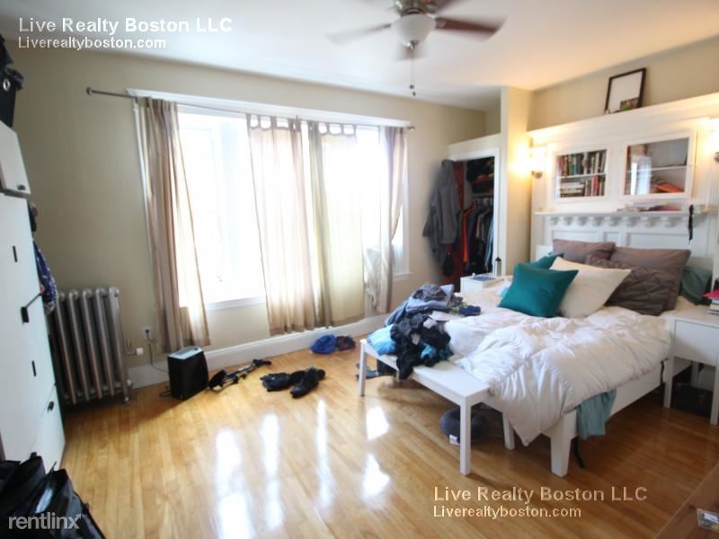
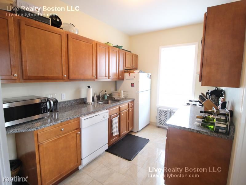
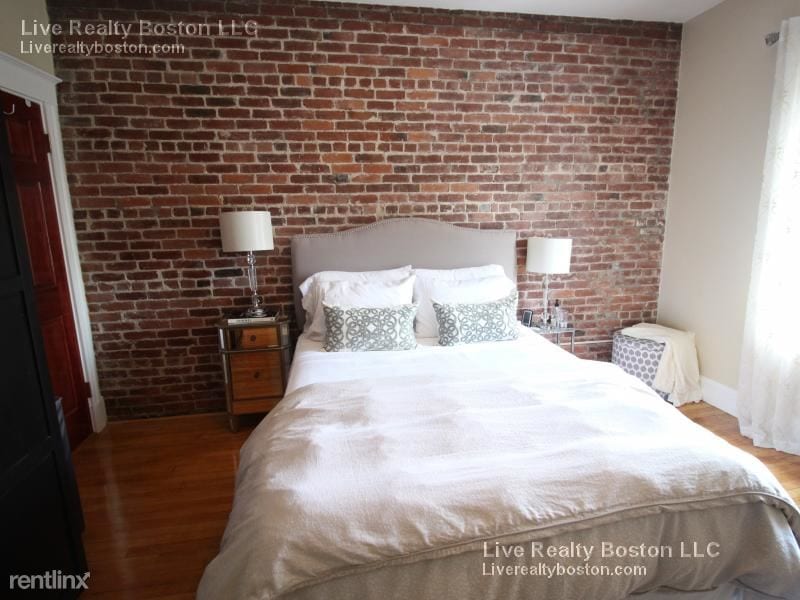
(978) 269-4077 - OUTSTANDING 3BD~HEAT INCLD~MODERN BTH~GREEN-B Located near Cambridge St. and Brighton Ave. This amazing 3 bed gem is just steps to the Green Line & the 66/57 Bus Line. Inside of this unit are shiny hardwood floors and lots of sunlight. All of the rooms are reasonably large and bright. The rooms are totally separate from the rest of the house so you will not disturb your roommates. Laundry is available in building. Parking is available No Pets Allowed (RLNE3176904) Other Amenities - Parking. Lease lengths - 12 Months. Details regarding this property's Utilities - Heat Included. Pet policies - No Pets Allowed.
56 Mansfield St is a condo located in Suffolk County and the 02134 ZIP Code. This area is served by the Boston Public Schools attendance zone.
Location
Get Directions
North Allston, also known as Lower Allston, is a peaceful neighborhood just five miles west of downtown Boston. This community is nestled along the Charles River and houses part of Harvard University, particularly Harvard Business School, Harvard Stadium, and the University’s other athletic fields.
In North Allston, you’ll find bike and pedestrian-friendly streets with an abundance of walking, biking, and jogging trails, community parks, and open green space overlooking the river. Enjoy delicious eats and drinks at Article 24, or try an old-school breakfast at a quaint corner diner known as the Breakfast Club. For the freshest baked goods in town, venture over to Swissbäkers on Western Avenue.
North Allston is a wonderful mix of student housing, upscale homes, and amenity-filled apartments and condos available for rent. Explore your options and find your ideal apartment in this quiet, affluent neighborhood near all of Boston’s major attractions.
Learn more about living in North AllstonBelow are rent ranges for similar nearby apartments
| Beds | Average Size | Lowest | Typical | Premium |
|---|---|---|---|---|
| Studio Studio Studio | 988-989 Sq Ft | $2,000 | $3,303 | $4,607 |
| 1 Bed 1 Bed 1 Bed | 1484-1487 Sq Ft | $1,800 | $3,742 | $6,187 |
| 2 Beds 2 Beds 2 Beds | 1682-1683 Sq Ft | $1,375 | $4,031 | $7,540 |
| 3 Beds 3 Beds 3 Beds | 5482 Sq Ft | $2,054 | $3,577 | $6,545 |
| 4 Beds 4 Beds 4 Beds | 3974-3975 Sq Ft | $925 | $4,349 | $10,000 |
Education
| Colleges & Universities | Distance | ||
|---|---|---|---|
| Colleges & Universities | Distance | ||
| Drive: | 4 min | 1.3 mi | |
| Drive: | 5 min | 1.8 mi | |
| Drive: | 6 min | 2.1 mi | |
| Drive: | 5 min | 2.1 mi |
56 Mansfield St is within 4 minutes or 1.3 miles from Harvard University. It is also near Cambridge College and Boston University.
Schools


Public Elementary & Middle School
Grades PK-8
352 Students
Attendance Zone
Public Elementary & Middle School
Grades PK-8
386 Students
Attendance Zone
Public Middle & High School
Grades 7-12
532 Students
Attendance Zone
Public Middle School
Grades 6-8
205 Students
Attendance Zone
Public Middle & High School
Grades 7-12
2,423 Students
Attendance Zone
Public High School
Grades 9-12
1,087 Students
Attendance Zone
Private Elementary, Middle & High School
Grades PK-12
281 Students
Nearby
School data provided by
 The GreatSchools Rating helps parents compare schools within a state based on a variety of school quality indicators and provides a helpful picture of how effectively each school serves all of its students. Ratings are on a scale of 1 (below average) to 10 (above average) and can include test scores, college readiness, academic progress, advanced courses, equity, discipline and attendance data. We also advise parents to visit schools, consider other information on school performance and programs, and consider family needs as part of the school selection process.
View GreatSchools Rating Methodology
Data provided by GreatSchools.org © 2025. All rights reserved.
View GreatSchools Rating Methodology
Data provided by GreatSchools.org © 2025. All rights reserved.
Transportation options available in Allston include Harvard Avenue, located 0.7 mile from 56 Mansfield St. 56 Mansfield St is near General Edward Lawrence Logan International, located 8.0 miles or 14 minutes away.
| Transit / Subway | Distance | ||
|---|---|---|---|
| Transit / Subway | Distance | ||
|
|
Walk: | 14 min | 0.7 mi |
| Drive: | 3 min | 1.2 mi | |
|
|
Drive: | 3 min | 1.2 mi |
| Drive: | 3 min | 1.4 mi | |
| Drive: | 4 min | 1.4 mi |
| Commuter Rail | Distance | ||
|---|---|---|---|
| Commuter Rail | Distance | ||
| Drive: | 4 min | 2.1 mi | |
|
|
Drive: | 6 min | 2.4 mi |
|
|
Drive: | 8 min | 3.7 mi |
|
|
Drive: | 9 min | 3.9 mi |
| Drive: | 11 min | 5.4 mi |
| Airports | Distance | ||
|---|---|---|---|
| Airports | Distance | ||
|
General Edward Lawrence Logan International
|
Drive: | 14 min | 8.0 mi |
Time and distance from 56 Mansfield St.
| Shopping Centers | Distance | ||
|---|---|---|---|
| Shopping Centers | Distance | ||
| Walk: | 8 min | 0.4 mi | |
| Drive: | 4 min | 1.2 mi | |
| Drive: | 4 min | 1.2 mi |
56 Mansfield St has 3 shopping centers within 1.2 miles, which is about a 4-minute walk. The miles and minutes will be for the farthest away property.
| Parks and Recreation | Distance | ||
|---|---|---|---|
| Parks and Recreation | Distance | ||
|
John Fitzgerald Kennedy National Historic Site
|
Drive: | 4 min | 1.6 mi |
|
Longfellow National Historic Site
|
Drive: | 5 min | 1.8 mi |
|
Harvard Museum of Natural History
|
Drive: | 6 min | 2.1 mi |
|
Harvard-Smithsonian Center for Astrophysics
|
Drive: | 7 min | 2.2 mi |
|
Coit Observatory
|
Drive: | 6 min | 2.6 mi |
56 Mansfield St has 5 parks within 2.6 miles, including John Fitzgerald Kennedy National Historic Site, Longfellow National Historic Site, and Coit Observatory.
| Hospitals | Distance | ||
|---|---|---|---|
| Hospitals | Distance | ||
| Drive: | 4 min | 1.4 mi | |
| Drive: | 4 min | 1.4 mi | |
| Drive: | 4 min | 1.5 mi |
56 Mansfield St has 3 hospitals within 1.5 miles, the nearest is Arbour Human Resource Institute which is 1.4 miles away and a 4 minute drive.
| Military Bases | Distance | ||
|---|---|---|---|
| Military Bases | Distance | ||
| Drive: | 25 min | 12.9 mi | |
| Drive: | 27 min | 15.3 mi |
56 Mansfield St is 12.9 miles from Hanscom Air Force Base, and is convenient to other military bases, including US Military Reservation.
You May Also Like
Similar Rentals Nearby


What Are Walk Score®, Transit Score®, and Bike Score® Ratings?
Walk Score® measures the walkability of any address. Transit Score® measures access to public transit. Bike Score® measures the bikeability of any address.
What is a Sound Score Rating?
A Sound Score Rating aggregates noise caused by vehicle traffic, airplane traffic and local sources
56 Mansfield St
Allston, MA 02134