
55 92nd St
55 92nd St,
Brooklyn,
NY
11209
2 Weeks Ago
Favorites
55 92nd St

Favorites
Check Back Soon for Upcoming Availability
Fees and Policies
The fees below are based on community-supplied data and may exclude additional fees and utilities.
Details
Lease Options
-
12 Months
Property Information
-
3 units
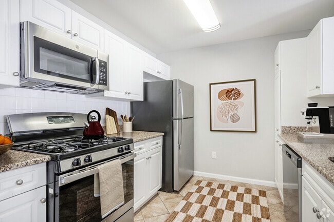
About 55 92nd St Brooklyn, NY 11209
Bay ridge shore rd Beautiful Art Deco bldg 1/2 block from shore rd Offers unique one of a kind huge beautiful king size 2 Bedrm 2 Bath Duplex apt. Features EIk xlarge LR dining area. Front facing. Hardwood flrs thru-out High ceils. Super on premises. Laundry facility. Nr xpress bus Public trans,shopping restaurants, cafes Shore rd promenade & Ferries. $2675
55 92nd St is an apartment community located in Kings County and the 11209 ZIP Code.
Apartment Features
- Washer/Dryer
- Dining Room
- Laundry Facilities
Location
Get Directions
Bay Ridge’s name can be taken quite literally, seeing as the neighborhood is situated on the ridge of New York’s Upper Bay in the bustling borough of Brooklyn. This urban, coastal oasis is known for its picturesque residential streets and slight seclusion from big city living.
Though Bay Ridge is an urban neighborhood, many residents applaud this coastal town for its ability to offer a suburban vibe and family-friendly atmosphere amidst its New York City location. Apartments, houses, condos, and townhomes range from cozy to luxury, so there’s something for everyone in this welcoming community.
Towering trees line the residential and commercial streets of Bay Ridge, giving it a park-like feel. And speaking of parks, this neighborhood’s entire coastline is covered by community parks featuring waterfront lawns, tall trees, and recreational amenities.
Learn more about living in Bay RidgeBelow are rent ranges for similar nearby apartments
Amenities
- Washer/Dryer
- Dining Room
- Laundry Facilities
Education
| Colleges & Universities | Distance | ||
|---|---|---|---|
| Colleges & Universities | Distance | ||
| Drive: | 14 min | 5.8 mi | |
| Drive: | 18 min | 6.6 mi | |
| Drive: | 14 min | 7.1 mi | |
| Drive: | 16 min | 7.6 mi |
55 92nd St is within 16 minutes or 7.6 miles from Brooklyn College. It is also near Wagner College and Medgar Evers College, CUNY.
Transportation options available in Brooklyn include Bay Ridge-95 St, located 0.6 mile from 55 92nd St. 55 92nd St is near Newark Liberty International, located 20.1 miles or 33 minutes away, and John F Kennedy International, located 20.3 miles or 29 minutes away.
| Transit / Subway | Distance | ||
|---|---|---|---|
| Transit / Subway | Distance | ||
|
|
Walk: | 10 min | 0.6 mi |
|
|
Walk: | 15 min | 0.8 mi |
|
|
Drive: | 4 min | 1.5 mi |
|
|
Drive: | 5 min | 1.8 mi |
|
|
Drive: | 8 min | 2.8 mi |
| Commuter Rail | Distance | ||
|---|---|---|---|
| Commuter Rail | Distance | ||
|
|
Drive: | 11 min | 5.1 mi |
|
|
Drive: | 12 min | 5.4 mi |
|
|
Drive: | 14 min | 6.0 mi |
|
|
Drive: | 16 min | 6.7 mi |
|
|
Drive: | 19 min | 7.3 mi |
| Airports | Distance | ||
|---|---|---|---|
| Airports | Distance | ||
|
Newark Liberty International
|
Drive: | 33 min | 20.1 mi |
|
John F Kennedy International
|
Drive: | 29 min | 20.3 mi |
Time and distance from 55 92nd St.
| Shopping Centers | Distance | ||
|---|---|---|---|
| Shopping Centers | Distance | ||
| Walk: | 17 min | 0.9 mi | |
| Drive: | 6 min | 2.2 mi | |
| Drive: | 9 min | 3.1 mi |
55 92nd St has 3 shopping centers within 3.1 miles, which is about a 9-minute walk. The miles and minutes will be for the farthest away property.
| Parks and Recreation | Distance | ||
|---|---|---|---|
| Parks and Recreation | Distance | ||
|
Dyker Beach Park
|
Drive: | 4 min | 1.4 mi |
|
Owl's Head Park
|
Drive: | 4 min | 1.7 mi |
|
Narrows Botanical Gardens
|
Drive: | 5 min | 2.8 mi |
|
Gateway NRA - Staten Island Unit -Fort Wadsworth
|
Drive: | 9 min | 4.1 mi |
|
Alice Austen Park
|
Drive: | 11 min | 5.1 mi |
55 92nd St has 5 parks within 5.1 miles, including Narrows Botanical Gardens, Dyker Beach Park, and Owl's Head Park.
| Hospitals | Distance | ||
|---|---|---|---|
| Hospitals | Distance | ||
| Drive: | 9 min | 3.2 mi | |
| Drive: | 15 min | 6.3 mi | |
| Drive: | 16 min | 7.5 mi |
55 92nd St has 3 hospitals within 7.5 miles, the nearest is Maimonides Medical Center which is 3.2 miles away and a 9 minute drive.
| Military Bases | Distance | ||
|---|---|---|---|
| Military Bases | Distance | ||
| Drive: | 5 min | 1.5 mi | |
| Drive: | 15 min | 6.3 mi |
55 92nd St is 1.5 miles from Fort Hamilton, and is convenient to other military bases, including Naval Station NY Stapleton Site.
You May Also Like
Similar Rentals Nearby


What Are Walk Score®, Transit Score®, and Bike Score® Ratings?
Walk Score® measures the walkability of any address. Transit Score® measures access to public transit. Bike Score® measures the bikeability of any address.
What is a Sound Score Rating?
A Sound Score Rating aggregates noise caused by vehicle traffic, airplane traffic and local sources