$1,900
/ Month
5450 E McLellan Rd
Mesa, AZ 85205
Today
|
Edit
Favorites
602-390-4600
-
Bedrooms
2
-
Bathrooms
2
-
Square Feet
1,293 sq ft
-
Available
Available Now
Highlights
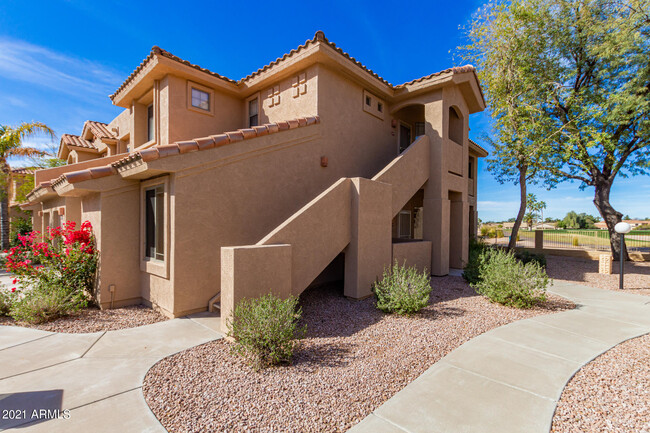
- On Golf Course
- Clubhouse
- Main Floor Primary Bedroom
- Furnished
- Fenced Community Pool
- Split Bedroom Floorplan
5450 E McLellan Rd

Favorites
About This Home
$1,000 deposit,
Available Now
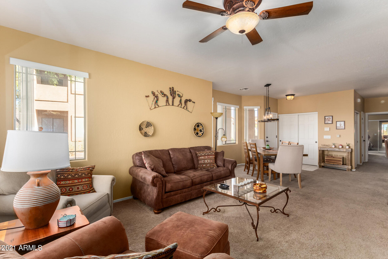
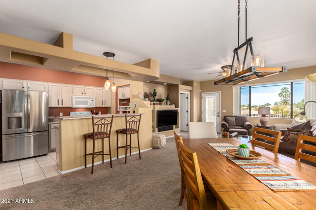
Fully furnished vacation or short term rental. 2 bdrm 2 bath. Lower level with no stairs Up to date comfortable furnishings. Split floorplan for guest. Full size washer and dryer. Unit overlooks the golf course. Rent varies with the season Check the availability calendar. Tax lic 21386043
5450 E McLellan Rd is a townhome located in Maricopa County and the 85205 ZIP Code. This area is served by the Mesa Unified School District attendance zone.
* Price shown is base rent. Excludes user-selected optional fees and variable or usage-based fees and required charges due at or prior to move-in or at move-out. Price, availability, fees, and any applicable rent special are subject to change without notice.
* Square footage definitions vary. Displayed square footage is approximate.
Home Details
Home Type
Townhome
Year Built
Built in 2000
Bedrooms and Bathrooms
Primary Bedroom on Main
Split Bedroom Floorplan
Primary Bathroom includes a Walk-In Shower
Double Vanity
Walk-In Closet
2 Full Bathrooms
2 Bedrooms
Eco-Friendly Details
Smoke Free Home
North or South Exposure
Flooring
Tile
Carpet
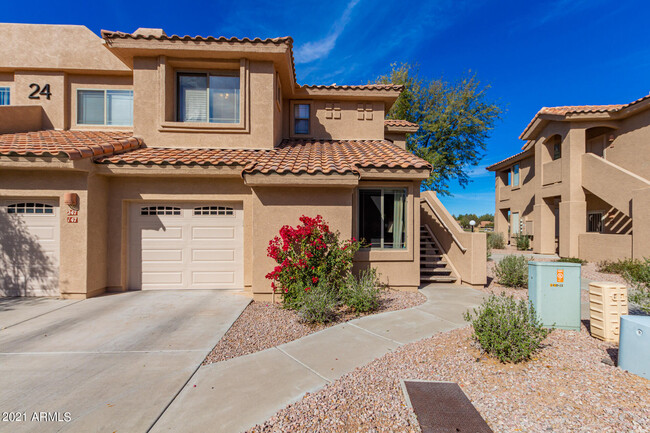
Home Design
Tile Roof
Stucco
Wood Frame Construction
Interior Spaces
Furnished
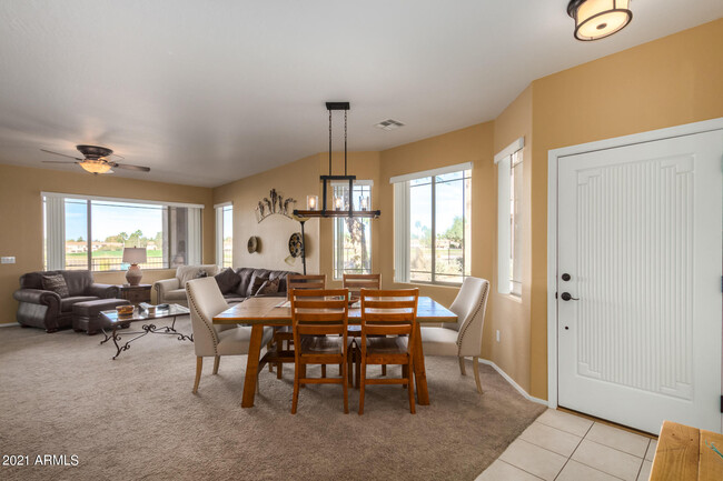
Combination Dining and Living Room
1,293 Sq Ft Home
2-Story Property
Vertical Blinds
Kitchen
Walk-In Pantry
Electric Range
Breakfast Bar
Electric Oven
Microwave
Dishwasher
Disposal
Laundry
Dryer
Washer
Listing and Financial Details
1-Month Minimum Lease Term
Tax Lot 147
Assessor Parcel Number 141-44-286
Rent includes electricity, water, sewer, garbage collection, linen, dishes, repairs, cable TV, utility caps apply, internet
Lot Details
On Golf Course
Desert faces the front and back of the property
Partially Fenced Property
Parking
1 Car Garage
Schools
Mendoza Elementary School
Shepherd Junior High School
Red Mountain High School
Utilities
Central Air
Heating Available
Community Details
Amenities
Clubhouse
Overview
Property has a Home Owners Association
Alta Mesa Association, Phone Number (602) 000-0000
Alta Mesa Subdivision
Pet Policy
Call for details about the types of pets allowed
Recreation
Fenced Community Pool
Fees and Policies
Details
Property Information
-
Furnished Units Available
Contact
- Listed by Janet H. McSpadden | Arizona Focus Realty
- Phone Number
- Contact
-
Source
Arizona Regional MLS
Copyright 2026 Arizona Regional MLS. All rights reserved. Information is deemed reliable but not guaranteed.
Location
Get Directions
Mesa combines suburban living with city conveniences as Arizona's third-largest city. Spanning 143 square miles across the Sonoran Desert, the city features both established neighborhoods and newer developments. At its heart, downtown Mesa hosts the Mesa Arts Center, offering year-round performances and exhibits. The rental market shows average rates from $1,117 for studios to $2,585 for four-bedroom homes, with recent decreases between 0.8% to 2.5% year-over-year. Notable areas include Dobson Ranch with its golf course and lakes, the Las Sendas area near Red Mountain, and the developing Gateway district by Phoenix-Mesa Gateway Airport.
The city's heritage includes ancient Hohokam canals that still shape Mesa's water infrastructure today. Residents enjoy Red Mountain Park's 1,146 acres of recreational space, spring baseball at Sloan Park (home to Chicago Cubs training), and educational opportunities at Mesa Community College and ASU's Polytechnic campus.
Learn more about living in Mesa
Amenities
- Furnished
Education
| Colleges & Universities | Distance | ||
|---|---|---|---|
| Colleges & Universities | Distance | ||
| Drive: | 6 min | 2.6 mi | |
| Drive: | 13 min | 6.1 mi | |
| Drive: | 17 min | 8.4 mi | |
| Drive: | 16 min | 8.9 mi |
5450 E McLellan Rd is within 6 minutes or 2.6 miles from Mesa C.C., Red Mountain Campus. It is also near A.T. Still Univ. AZ and Mesa C.C., Downtown Center.
Schools


Public Elementary School
Grades PK-5
Attendance Zone
Public Elementary & Middle School
Grades K-8
Attendance Zone
Public High School
Grades 9-12
Attendance Zone
Private Elementary, Middle & High School
Grades PK-12
Nearby
Private Elementary, Middle & High School
Grades K-12
Nearby
School data provided by
 The GreatSchools Rating helps parents compare schools within a state based on a variety of school quality indicators and provides a helpful picture of how effectively each school serves all of its students. Ratings are on a scale of 1 (below average) to 10 (above average) and can include test scores, college readiness, academic progress, advanced courses, equity, discipline and attendance data. We also advise parents to visit schools, consider other information on school performance and programs, and consider family needs as part of the school selection process.
View GreatSchools Rating Methodology
Data provided by GreatSchools.org © 2026. All rights reserved.
View GreatSchools Rating Methodology
Data provided by GreatSchools.org © 2026. All rights reserved.
Transportation options available in Mesa include Gilbert Rd/Main St, located 7.1 miles from 5450 E McLellan Rd. 5450 E McLellan Rd is near Phoenix-Mesa Gateway, located 12.9 miles or 24 minutes away, and Phoenix Sky Harbor International, located 18.3 miles or 30 minutes away.
| Transit / Subway | Distance | ||
|---|---|---|---|
| Transit / Subway | Distance | ||
|
|
Drive: | 13 min | 7.1 mi |
|
|
Drive: | 14 min | 7.6 mi |
|
|
Drive: | 15 min | 8.5 mi |
|
|
Drive: | 17 min | 9.1 mi |
|
|
Drive: | 18 min | 9.5 mi |
| Commuter Rail | Distance | ||
|---|---|---|---|
| Commuter Rail | Distance | ||
|
|
Drive: | 58 min | 42.8 mi |
| Airports | Distance | ||
|---|---|---|---|
| Airports | Distance | ||
|
Phoenix-Mesa Gateway
|
Drive: | 24 min | 12.9 mi |
|
Phoenix Sky Harbor International
|
Drive: | 30 min | 18.3 mi |
Getting Around
 What do Walkability, Transit, Drivability, and Bikeability mean?
Walkability measures the walking distance to day-to-day needs.
Transit measures access to public transportation.
Drivability measures congestion, parking availability, and access to major roads.
Bikeability measures the suitability for cycling.
How It Works
What do Walkability, Transit, Drivability, and Bikeability mean?
Walkability measures the walking distance to day-to-day needs.
Transit measures access to public transportation.
Drivability measures congestion, parking availability, and access to major roads.
Bikeability measures the suitability for cycling.
How It Works
Fairly Walkable
Walkability
40
/ 100
Minimal Public Transit
Transit
0
/ 100
Exceptionally Drivable
Drivability
90
/ 100
Fairly Bikeable
Bikeability
50
/ 100
Scores provided by
Active
Soundscore™
75
/ 100
Traffic
ActiveAirport
ActiveBusinesses
CalmScores provided by
HowLoud What is a Sound Score Rating? A Sound Score Rating aggregates noise caused by vehicle traffic, airplane traffic and local sources. How It WorksTime and distance from 5450 E McLellan Rd.
| Shopping Centers | Distance | ||
|---|---|---|---|
| Shopping Centers | Distance | ||
| Walk: | 9 min | 0.5 mi | |
| Walk: | 12 min | 0.7 mi | |
| Walk: | 13 min | 0.7 mi |
5450 E McLellan Rd has 3 shopping centers within 0.7 mile, which is about a 13-minute walk. The miles and minutes will be for the farthest away property.
| Parks and Recreation | Distance | ||
|---|---|---|---|
| Parks and Recreation | Distance | ||
|
Red Mountain Park
|
Drive: | 8 min | 4.1 mi |
|
Riparian Preserve at Water Ranch
|
Drive: | 13 min | 6.9 mi |
|
Usery Mountain Recreation Area
|
Drive: | 19 min | 8.4 mi |
|
Arizona Museum of Natural History
|
Drive: | 17 min | 9.2 mi |
|
i.d.e.a. Museum
|
Drive: | 18 min | 9.4 mi |
5450 E McLellan Rd has 5 parks within 9.4 miles, including Red Mountain Park, Riparian Preserve at Water Ranch, and Usery Mountain Recreation Area.
| Hospitals | Distance | ||
|---|---|---|---|
| Hospitals | Distance | ||
| Drive: | 9 min | 4.7 mi | |
| Drive: | 9 min | 4.8 mi | |
| Drive: | 9 min | 4.9 mi |
5450 E McLellan Rd has 3 hospitals within 4.9 miles, the nearest is Banner Gateway Medical Center which is 4.7 miles away and a 9 minute drive.
| Military Bases | Distance | ||
|---|---|---|---|
| Military Bases | Distance | ||
| Drive: | 35 min | 25.4 mi | |
| Drive: | 61 min | 44.0 mi | |
| Drive: | 126 min | 101.6 mi |
5450 E McLellan Rd has 3 military bases within 101.6 miles, the nearest is Phoenix Sky Harbor Airport Air Guard Station which is 25.4 miles away and a 35 minute drive.
You May Also Like
Similar Rentals Nearby
-
-
-
-
-
-
-
-
-
2 Beds$1,699+3 Beds$2,578+Total Monthly PriceTotal Monthly Price NewPrices include base rent and required monthly fees of $33. Variable costs based on usage may apply.Base Rent:2 Beds$1,666+3 Beds$2,545+1 Month Free
Pets Allowed Fitness Center Pool Dishwasher In Unit Washer & Dryer Clubhouse Stainless Steel Appliances
-


What Are Walk Score®, Transit Score®, and Bike Score® Ratings?
Walk Score® measures the walkability of any address. Transit Score® measures access to public transit. Bike Score® measures the bikeability of any address.
What is a Sound Score Rating?
A Sound Score Rating aggregates noise caused by vehicle traffic, airplane traffic and local sources.

5450 E McLellan Rd
Mesa, AZ 85205