
$1,500
/ Month
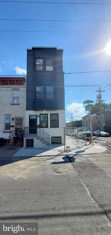
536 W Huntingdon St
Philadelphia, PA 19133
2 Days Ago
Favorites
267-259-6524
-
Bedrooms
2
-
Bathrooms
2
-
Square Feet
--
-
Available
Available Now
Highlights
- Built in 2022 | New Construction
- Central Heating and Cooling System
- Property is in excellent condition
536 W Huntingdon St

Favorites
About This Home
Available Now
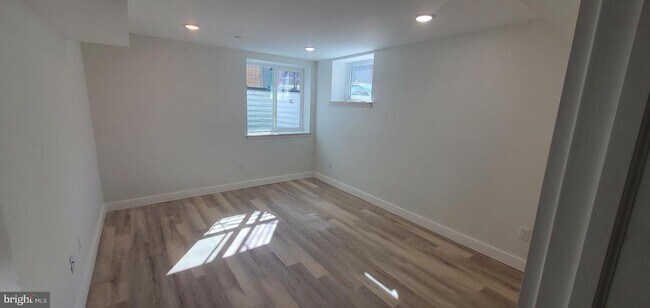
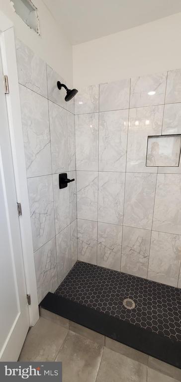
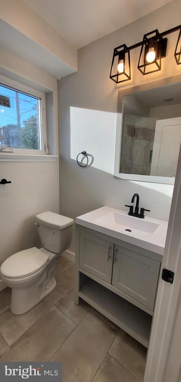
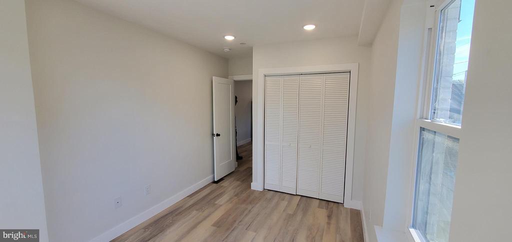
ONE MONTH FREE!!! ONE MONTH FREE!!! ONE MONTH FREE!!! A brand-new 2 bedroom 2 bathroom bi-level apartment featuring an open concept living area, hardwood floor throughout the entire apartment, The apartment is equipped with brand new stainless steel appliances such as stove, microwave, fridge, and dishwasher along with custom-built cabinetry, quartz counter-tops, garbage disposal, and in-unit washer/dryer. Enjoy your private entrance along with good sized yard for outdoor activities. This beautiful apartment is located close to public transportation and only minutes away from Northern Liberties and other major areas in the city. Come see it for yourself, make it yours!
Unique Features
- NewConstruction
536 W Huntingdon St is a townhome located in Philadelphia County and the 19133 ZIP Code. This area is served by the The School District of Philadelphia attendance zone.
* Price shown is base rent. Excludes user-selected optional fees and variable or usage-based fees and required charges due at or prior to move-in or at move-out. Price, availability, fees, and any applicable rent special are subject to change without notice.
* Square footage definitions vary. Displayed square footage is approximate.
Home Details
Home Type
End Unit Townhome
Year Built
Built in 2022 | New Construction
Bedrooms and Bathrooms
2 Bedrooms | 1 Main Level Bedroom
2 Full Bathrooms
Home Design
Brick Exterior Construction
Concrete Perimeter Foundation
Interior Spaces
1,200 Sq Ft Home
Property has 2 Levels
Listing and Financial Details
Security Deposit $1,500
12-Month Min and 24-Month Max Lease Term
Available 8/2/25
Assessor Parcel Number 192310901
Residential Lease
Lot Details
840 Sq Ft Lot
Property is in excellent condition
Lot Dimensions are 14.00 x 60.00
Parking
On-Street Parking
Utilities
Central Heating and Cooling System
Electric Water Heater
Community Details
Overview
West Kensington Subdivision
Pet Policy
Pets allowed on a case-by-case basis
Contact
- Listed by Mina Sedarous | Long & Foster Real Estate, Inc.
- Phone Number
- Contact
-
Source
 Bright MLS, Inc.
Copyright © 2025 Bright MLS, Inc.
Location
Get Directions
Amenities
- Basement
- NewConstruction
Not to be confused with Northeast Philadelphia, North Philadelphia East encompasses the smaller subsets of Ludlow, Yorktown, West Kensington, Poplar, and Callowhill. This composite area runs from the Vine Street Expressway, stretching north to Erie Avenue. Broad Street acts as its eastern border, and the western edge runs a jagged line separating North Philadelphia East from the nearby Kensington, Port Richmond, and Fishtown neighborhoods. With such a long stretch of city, the neighborhood offers a diverse blend of important city landmarks, such as renowned musical venues the Electric Factory and Union Transfer, and Temple University, North Philadelphia's premiere site of higher learning.
Learn more about living in North Philadelphia East
Education
| Colleges & Universities | Distance | ||
|---|---|---|---|
| Colleges & Universities | Distance | ||
| Drive: | 3 min | 1.4 mi | |
| Drive: | 5 min | 2.0 mi | |
| Drive: | 8 min | 3.2 mi | |
| Drive: | 9 min | 3.5 mi |
536 W Huntingdon St is within 5 minutes or 2.0 miles from Temple University, Main Campus. It is also near Temple Univ., Health Center and C.C. of Philadelphia.
Schools


Public Elementary & Middle School
Grades K-8
253 Students
Attendance Zone
Public Elementary & Middle School
Grades PK-8
355 Students
Nearby
Public High School
Grades 9-12
459 Students
Attendance Zone
Private Elementary School
Grades K-5
71 Students
Nearby
Private Elementary, Middle & High School
Grades K-10
Nearby
Private Elementary, Middle & High School
Grades PK-12
88 Students
Nearby
School data provided by
 The GreatSchools Rating helps parents compare schools within a state based on a variety of school quality indicators and provides a helpful picture of how effectively each school serves all of its students. Ratings are on a scale of 1 (below average) to 10 (above average) and can include test scores, college readiness, academic progress, advanced courses, equity, discipline and attendance data. We also advise parents to visit schools, consider other information on school performance and programs, and consider family needs as part of the school selection process.
View GreatSchools Rating Methodology
Data provided by GreatSchools.org © 2025. All rights reserved.
View GreatSchools Rating Methodology
Data provided by GreatSchools.org © 2025. All rights reserved.
Transportation options available in Philadelphia include Susquehanna-Dauphin, located 1.0 miles from 536 W Huntingdon St. 536 W Huntingdon St is near Philadelphia International, located 15.5 miles or 26 minutes away, and Trenton Mercer, located 32.4 miles or 48 minutes away.
| Transit / Subway | Distance | ||
|---|---|---|---|
| Transit / Subway | Distance | ||
|
|
Walk: | 19 min | 1.0 mi |
|
|
Drive: | 2 min | 1.1 mi |
|
|
Drive: | 3 min | 1.1 mi |
|
|
Drive: | 3 min | 1.3 mi |
|
|
Drive: | 4 min | 1.6 mi |
| Commuter Rail | Distance | ||
|---|---|---|---|
| Commuter Rail | Distance | ||
|
|
Walk: | 17 min | 0.9 mi |
|
|
Walk: | 21 min | 1.1 mi |
|
|
Drive: | 3 min | 1.1 mi |
|
|
Drive: | 4 min | 1.3 mi |
|
|
Drive: | 4 min | 2.0 mi |
| Airports | Distance | ||
|---|---|---|---|
| Airports | Distance | ||
|
Philadelphia International
|
Drive: | 26 min | 15.5 mi |
|
Trenton Mercer
|
Drive: | 48 min | 32.4 mi |
Time and distance from 536 W Huntingdon St.
| Shopping Centers | Distance | ||
|---|---|---|---|
| Shopping Centers | Distance | ||
| Walk: | 6 min | 0.3 mi | |
| Walk: | 18 min | 1.0 mi | |
| Walk: | 23 min | 1.2 mi |
536 W Huntingdon St has 3 shopping centers within 1.2 miles, which is about a 23-minute walk. The miles and minutes will be for the farthest away property.
| Parks and Recreation | Distance | ||
|---|---|---|---|
| Parks and Recreation | Distance | ||
|
Wagner Free Institute of Science
|
Drive: | 6 min | 1.8 mi |
|
Edgar Allan Poe Nat'l Historic Site
|
Drive: | 6 min | 2.3 mi |
|
Independence National Historical Park
|
Drive: | 7 min | 2.8 mi |
|
The Academy of Natural Sciences
|
Drive: | 9 min | 3.7 mi |
|
Fels Planetarium
|
Drive: | 9 min | 4.2 mi |
536 W Huntingdon St has 5 parks within 4.2 miles, including Wagner Free Institute of Science, Edgar Allan Poe Nat'l Historic Site, and Independence National Historical Park.
| Hospitals | Distance | ||
|---|---|---|---|
| Hospitals | Distance | ||
| Drive: | 3 min | 1.5 mi | |
| Drive: | 4 min | 1.7 mi | |
| Drive: | 4 min | 1.8 mi |
536 W Huntingdon St has 3 hospitals within 1.8 miles, the nearest is Temple University Hospital which is 1.5 miles away and a 3 minute drive.
| Military Bases | Distance | ||
|---|---|---|---|
| Military Bases | Distance | ||
| Drive: | 17 min | 9.9 mi |
536 W Huntingdon St is 9.9 miles and a 17 minute drive from Philadelphia Naval Busi Center.
You May Also Like
Similar Rentals Nearby
-
-
-
-
-
-
-
-
1 / 24

-
-


What Are Walk Score®, Transit Score®, and Bike Score® Ratings?
Walk Score® measures the walkability of any address. Transit Score® measures access to public transit. Bike Score® measures the bikeability of any address.
What is a Sound Score Rating?
A Sound Score Rating aggregates noise caused by vehicle traffic, airplane traffic and local sources
536 W Huntingdon St
Philadelphia, PA 19133