$1,950
/ Month
453-451 51st St
Brooklyn, NY 11220
2 Weeks Ago
Favorites
51 STREET

Favorites
Check Back Soon for Upcoming Availability
| Beds | Baths | Average SF |
|---|---|---|
| 1 Bedroom 1 Bedroom 1 Br | 1 Bath 1 Bath 1 Ba | — |
About This Property
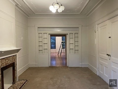
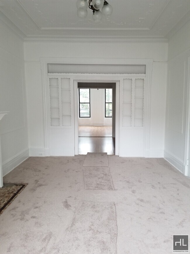
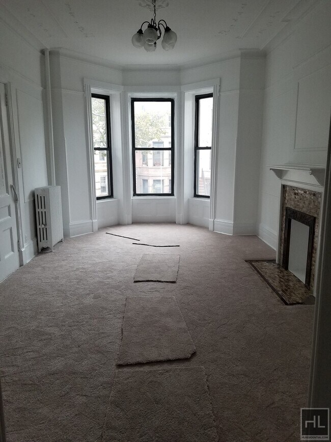
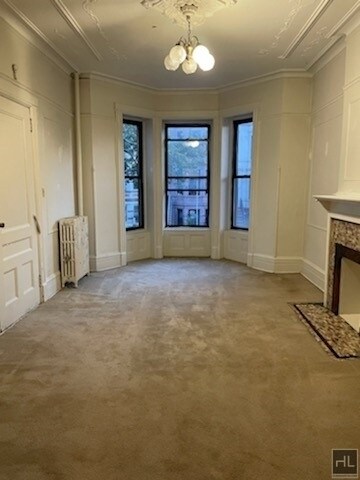
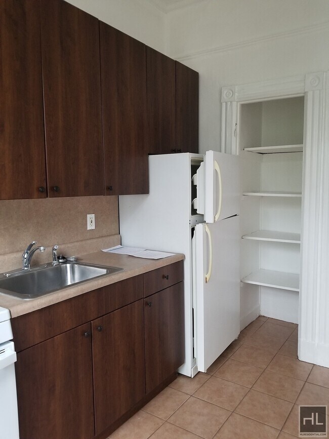
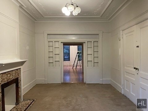
Please Note: Earliest Move in date Is September 1st !!!!! ---15% Broker Fee Applies --- Charming 1 bedroom parlor floor gem in a classic Brooklyn brownstone on a tree-lined street in prime Sunset Park! Featuring Hardwood floors and high ceilings throughout. Second floor apartment with great light!! Also a home office space for a rec room work space. Spacious kitchen with great cabinetry storage and window. Apartment Features: - Large bedroom- Spacious living room area- Nice eat-in kitchen space- Full bathroom- High ceilings- Heat and hot water included Pets are case by case Just two blocks to the R train at 53rd Street and within close proximity to shopping, restaurants and nearby Sunset Park. This apartment will not last. Please email for an appointment!===Ref:1713263===
51 STREET is an apartment community located in Kings County and the 11220 ZIP Code.
Location
Get Directions
Situated on the Upper Bay of the Hudson River, Sunset Park is a vibrant neighborhood in southwestern Brooklyn. The neighborhood is home to a park of the same name, featuring 24.5 acres of space for outdoor recreation as well as stunning views of the Manhattan skyline.
Tucked between Park Slope and Bay Ridge, Sunset Park is known for its diverse restaurants, lively festivals, and numerous supermarkets. Sunset Park also contains Industry City, a complex of towering warehouses on cobblestone streets, which houses a slew of coffee shops, eateries, art galleries, and offices for hundreds of companies. Convenience to the D, N, and R subway lines places Sunset Park within minutes of all that NYC has to offer.
Learn more about living in Sunset ParkBelow are rent ranges for similar nearby apartments
Education
| Colleges & Universities | Distance | ||
|---|---|---|---|
| Colleges & Universities | Distance | ||
| Drive: | 10 min | 4.0 mi | |
| Drive: | 10 min | 4.3 mi | |
| Drive: | 13 min | 4.7 mi | |
| Drive: | 12 min | 4.7 mi |
51 STREET is within 13 minutes or 4.7 miles from Brooklyn College. It is also near Brooklyn Law School and Medgar Evers College, CUNY.
Transportation options available in Brooklyn include 53 Street, located 0.2 mile from 51 STREET. 51 STREET is near LaGuardia, located 14.5 miles or 27 minutes away, and Newark Liberty International, located 18.0 miles or 31 minutes away.
| Transit / Subway | Distance | ||
|---|---|---|---|
| Transit / Subway | Distance | ||
|
|
Walk: | 3 min | 0.2 mi |
|
|
Walk: | 8 min | 0.4 mi |
|
|
Walk: | 9 min | 0.5 mi |
|
|
Walk: | 17 min | 0.9 mi |
|
|
Drive: | 4 min | 1.2 mi |
| Commuter Rail | Distance | ||
|---|---|---|---|
| Commuter Rail | Distance | ||
|
|
Drive: | 11 min | 4.0 mi |
|
|
Drive: | 13 min | 7.1 mi |
|
|
Drive: | 15 min | 7.7 mi |
|
|
Drive: | 17 min | 8.3 mi |
|
|
Drive: | 20 min | 8.9 mi |
| Airports | Distance | ||
|---|---|---|---|
| Airports | Distance | ||
|
LaGuardia
|
Drive: | 27 min | 14.5 mi |
|
Newark Liberty International
|
Drive: | 31 min | 18.0 mi |
Time and distance from 51 STREET.
| Shopping Centers | Distance | ||
|---|---|---|---|
| Shopping Centers | Distance | ||
| Drive: | 5 min | 1.7 mi | |
| Drive: | 4 min | 2.0 mi | |
| Drive: | 6 min | 2.6 mi |
51 STREET has 3 shopping centers within 2.6 miles, which is about a 6-minute drive. The miles and minutes will be for the farthest away property.
| Parks and Recreation | Distance | ||
|---|---|---|---|
| Parks and Recreation | Distance | ||
|
Sunset Park
|
Walk: | 12 min | 0.6 mi |
|
Owl's Head Park
|
Drive: | 5 min | 2.1 mi |
|
Red Hook Park
|
Drive: | 6 min | 3.0 mi |
|
Waterfront Museum & Showboat Barge
|
Drive: | 8 min | 3.8 mi |
|
Narrows Botanical Gardens
|
Drive: | 10 min | 5.0 mi |
51 STREET has 5 parks within 5.0 miles, including Sunset Park, Owl's Head Park, and Narrows Botanical Gardens.
| Hospitals | Distance | ||
|---|---|---|---|
| Hospitals | Distance | ||
| Drive: | 3 min | 1.2 mi | |
| Drive: | 8 min | 3.3 mi | |
| Drive: | 11 min | 4.7 mi |
51 STREET has 3 hospitals within 4.7 miles, the nearest is Maimonides Medical Center which is 1.2 miles away and a 3 minute drive.
| Military Bases | Distance | ||
|---|---|---|---|
| Military Bases | Distance | ||
| Drive: | 8 min | 3.6 mi | |
| Drive: | 14 min | 6.6 mi | |
| Drive: | 16 min | 7.9 mi |
51 STREET has 3 military bases within 7.9 miles, the nearest is Fort Hamilton which is 3.6 miles away and a 8 minute drive.
You May Also Like
-
The Courtyard @ Clifton: In-Unit Washer & ...
1 Kowal St
Clifton, NJ 07013
$2,650 - $2,750
1-2 Br 17.0 mi
-
Quincy Heights - Woodbridge Township
175 Quincy Ct
Perth Amboy, NJ 08861
$2,300 - $2,700
1-2 Br 17.3 mi
-
The East Hill: In-Unit Washer & Dryer, Hea...
14 Bliss Ave
Tenafly, NJ 07670
$2,250 - $3,450
1-2 Br 18.4 mi
Similar Rentals Nearby


What Are Walk Score®, Transit Score®, and Bike Score® Ratings?
Walk Score® measures the walkability of any address. Transit Score® measures access to public transit. Bike Score® measures the bikeability of any address.
What is a Sound Score Rating?
A Sound Score Rating aggregates noise caused by vehicle traffic, airplane traffic and local sources
453-451 51st St
Brooklyn, NY 11220