

$2,845 / Month
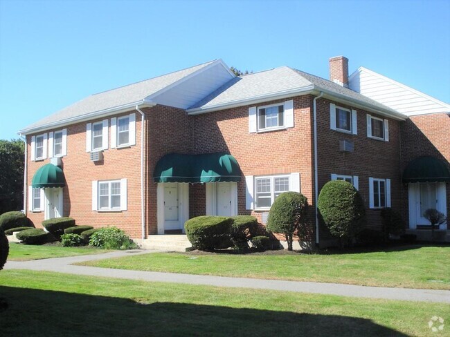
51 Colborne Path Unit 4
Boston, MA 02135
Today
Favorites
617-487-4868
-
Bedrooms
2
-
Bathrooms
1
-
Square Feet
760 sq ft
-
Available
Available Now
Highlights
- No Cooling
- Heating System Uses Natural Gas
51 Colborne Path Unit 4

Favorites
About This Home
$2,845 deposit,
Available Now
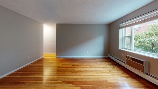
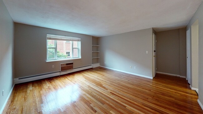
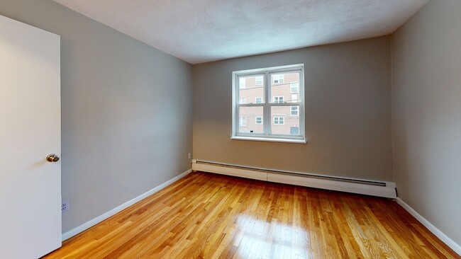
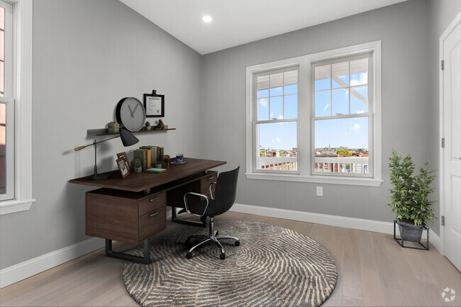
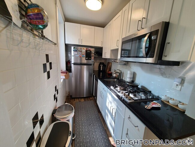
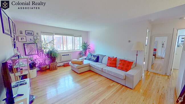
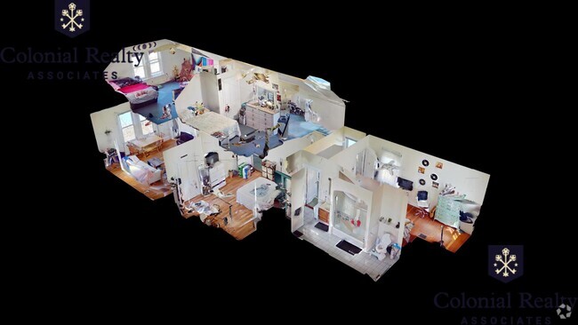
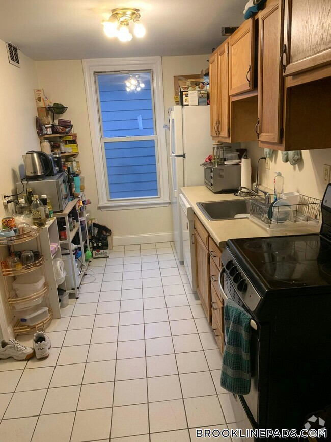
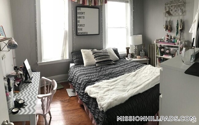
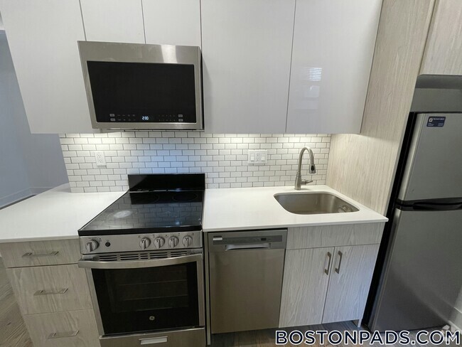
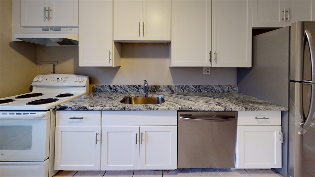
Welcome home to this well-maintained 2-bedroom,1-bath unit located on the first floor of a professionally managed townhouse-style building in Brighton’s vibrant Comm Ave corridor. With 760 square feet of living space,this home features hardwood floors throughout,a generously sized eat-in kitchen with updated countertops,full-size appliances,and excellent natural light. Heat and hot water are included in the rent,and laundry is conveniently located in the building. Outdoor parking is available for $150/month. The building is pet-friendly—cats are welcome and dogs are considered on a case-by-case basis. The layout offers good separation between bedrooms,ideal for roommates or remote workers. Located just minutes from the Green B Line,multiple bus routes,and neighborhood conveniences like cafes,grocery stores,and parks. Flexible on applicant background—graduate students and working professionals welcome.
51 Colborne Path is a condo located in Suffolk County and the 02135 ZIP Code.
* Price shown is base rent and may not include non-optional fees and utilities.
Price, availability, fees, and any applicable rent special are subject to change without notice.
* Square footage definitions vary. Displayed square footage is approximate.
Home Details
Home Type
Condominium
Accessible Home Design
Entry on the 1st floor
Bedrooms and Bathrooms
1 Full Bathroom
2 Bedrooms
Interior Spaces
760 Sq Ft Home
Listing and Financial Details
Security Deposit $2,845
Property Available on 9/1/25
12 Month Lease Term
Assessor Parcel Number 3348365
Rent includes heat, hot water
Parking
1 Car Parking Space
Utilities
No Cooling
Heating System Uses Natural Gas
Community Details
Overview
Property has a Home Owners Association
Pet Policy
Call for details about the types of pets allowed
Contact
- Listed by Jarrett Lau | Profitable Properties Boston LLC
- Phone Number
-
Source
 MLS Property Information Network
The property listing data and information set forth herein were provided to MLS Property Information Network, Inc. from third party sources, including sellers, lessors and public records, and were compiled by MLS Property Information Network, Inc. The property listing data and information are for the personal, non-commercial use of consumers having a good faith interest in purchasing or leasing listed properties of the type displayed to them and may not be used for any purpose other than to identify prospective properties which such consumers may have a good faith interest in purchasing or leasing. MLS Property Information Network, Inc. and its subscribers disclaim any and all representations and warranties as to the accuracy of the property listing data and information set forth herein. All properties are subject to prior sale, change or withdrawal. Copyright © 2025 MLS Property Information Network, Inc. All rights reserved.
Location
Get Directions
Saint Elizabeth’s is a Brighton neighborhood situated about 10 miles away from Boston. Thanks to Saint Elizabeth’s top border sitting on Highway 20, commuting in and out of Brighton is easy. Some residents travel by car, but buses and railways make commuting via public transportation a breeze.
The neighborhood’s best amenities are two world-renowned hospitals, Saint Elizabeth’s Medical Center and Franciscan Children’s, that sit on the edge of town. Other great amenities of Saint Elizabeth’s include many local parks like Ringer Playground and Chestnut Hill Reservoir, which has great trails and greenspace. This neighborhood is also equipped with cozy coffee shops, restaurants serving international and American classics, and shopping plazas with grocers and convenience stores.
Saint Elizabeth’s has several rental options ranging from apartments to single-family homes.
Learn more about living in St Elizabeth's
Education
| Colleges & Universities | Distance | ||
|---|---|---|---|
| Colleges & Universities | Distance | ||
| Drive: | 4 min | 1.5 mi | |
| Drive: | 4 min | 1.6 mi | |
| Drive: | 5 min | 2.4 mi | |
| Drive: | 7 min | 3.0 mi |
51 Colborne Path Unit 4 is within 4 minutes or 1.5 miles from Boston College, Brighton. It is also near Boston College and Boston University.
Transportation options available in Boston include Sutherland Street Station, located 0.2 mile from 51 Colborne Path Unit 4. 51 Colborne Path Unit 4 is near General Edward Lawrence Logan International, located 9.5 miles or 18 minutes away.
| Transit / Subway | Distance | ||
|---|---|---|---|
| Transit / Subway | Distance | ||
|
|
Walk: | 4 min | 0.2 mi |
|
|
Walk: | 7 min | 0.4 mi |
|
|
Walk: | 8 min | 0.4 mi |
|
|
Walk: | 13 min | 0.7 mi |
|
|
Drive: | 3 min | 1.1 mi |
| Commuter Rail | Distance | ||
|---|---|---|---|
| Commuter Rail | Distance | ||
|
|
Drive: | 8 min | 3.6 mi |
|
|
Drive: | 7 min | 3.6 mi |
|
|
Drive: | 8 min | 3.8 mi |
| Drive: | 9 min | 4.5 mi | |
|
|
Drive: | 10 min | 4.6 mi |
| Airports | Distance | ||
|---|---|---|---|
| Airports | Distance | ||
|
General Edward Lawrence Logan International
|
Drive: | 18 min | 9.5 mi |
Time and distance from 51 Colborne Path Unit 4.
| Shopping Centers | Distance | ||
|---|---|---|---|
| Shopping Centers | Distance | ||
| Walk: | 9 min | 0.5 mi | |
| Walk: | 16 min | 0.8 mi | |
| Drive: | 5 min | 1.5 mi |
51 Colborne Path Unit 4 has 3 shopping centers within 1.5 miles, which is about a 5-minute walk. The miles and minutes will be for the farthest away property.
| Parks and Recreation | Distance | ||
|---|---|---|---|
| Parks and Recreation | Distance | ||
|
Chestnut Hill Reservation
|
Walk: | 13 min | 0.7 mi |
|
John Fitzgerald Kennedy National Historic Site
|
Drive: | 4 min | 1.8 mi |
|
Frederick Law Olmsted National Historic Site
|
Drive: | 5 min | 2.4 mi |
|
Hammond Pond Reservation
|
Drive: | 6 min | 2.7 mi |
|
Coit Observatory
|
Drive: | 6 min | 2.9 mi |
51 Colborne Path Unit 4 has 5 parks within 2.9 miles, including Chestnut Hill Reservation, John Fitzgerald Kennedy National Historic Site, and Frederick Law Olmsted National Historic Site.
| Hospitals | Distance | ||
|---|---|---|---|
| Hospitals | Distance | ||
| Walk: | 12 min | 0.7 mi | |
| Walk: | 13 min | 0.7 mi | |
| Drive: | 4 min | 1.8 mi |
51 Colborne Path Unit 4 has 3 hospitals within 1.8 miles, the nearest is St. Elizabeth's Medical Center which is 0.7 mile away and a 12 minute walk.
| Military Bases | Distance | ||
|---|---|---|---|
| Military Bases | Distance | ||
| Drive: | 28 min | 12.7 mi | |
| Drive: | 23 min | 13.4 mi |
51 Colborne Path Unit 4 is 12.7 miles from Hanscom Air Force Base, and is convenient to other military bases, including US Military Reservation.
You May Also Like
Similar Rentals Nearby
What Are Walk Score®, Transit Score®, and Bike Score® Ratings?
Walk Score® measures the walkability of any address. Transit Score® measures access to public transit. Bike Score® measures the bikeability of any address.
What is a Sound Score Rating?
A Sound Score Rating aggregates noise caused by vehicle traffic, airplane traffic and local sources
51 Colborne Path
Boston, MA 02135