
$1,775 / Month
506 33rd St Unit 1
Oakland, CA 94609
2 Weeks Ago
Favorites
506 33rd St Unit 1

Favorites
Check Back Soon for Upcoming Availability
| Beds | Baths | Average SF |
|---|---|---|
| 1 Bedroom 1 Bedroom 1 Br | 1 Bath 1 Bath 1 Ba | 554 SF |
About This Property
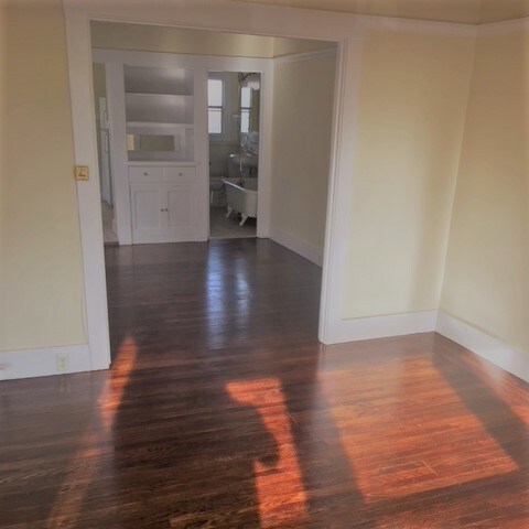
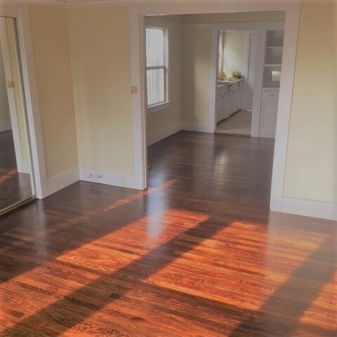
Freshly painted one bedroom unit with refinished hardwood floor. Great location, just 10 min walk to MacArthur BART Station. Plenty of natural light with large windows. OPEN HOUSE 12-9-2017 AT 1 PM or By Appointment Key Features: Spacious 1 bedroom in a four-unit apartment building Parking: Off Street parking Lease Duration: Year Lease Utilities: Owner pays water and garbage. Details: • Beds/Baths: 1/1 • Square Feet: 554(est.) • No Section 8 Rental Terms: • Rent: $1,775.00 • Available: 12/1/2017 • Application Fee: $35.00 • Pets Policy: No Dogs, No Cats, No Kidding. • Security Deposit: $2,000.00 Unit Description: • Gas stove • Good closet space • Newly painted • Refinished hardwood floors • Plenty of natural sunlight. • Off street parking for one vehicle Location Description: • City of Oakland • Alameda County • Pill Hill neighborhood (Between Lake Merritt and Temescal District) • Located 33rd Street • Close to MacArthur BART • Bus stops for AC Transit nearby • Minutes to San Francisco, Berkeley, Hayward, and San Leandro • Quick access to major highways 580, 80, 880, 24, and 13 • Close to Downtown and Jack London Square ________________________________________ BRE# 01142270 Copyright © 2015, AYS Management. All Rights Reserved. AYS Management believes all material to be correct but assumes no legal responsibility for the accuracy. All units' subject to prior rental, change or withdrawal without notice. For additional information contact Kevin by email, text or leave a message voice mail
506 33rd St is an apartment community located in Alameda County and the 94609 ZIP Code.
Location
Get Directions
Pill Hill is a small neighborhood located about a mile north of Downtown Oakland. Various medical facilities are located in the neighborhood, hence the name. Along with pharmacies and doctor’s offices, Pill Hill is home to the Alta Bates Summit Medical Center. Pill Hill has apartments and condos available for rent. The iconic Telegraph Avenue runs through Pill Hill so residents have access to cafes, coffee shops, and grocery stores within walking distance, but many residents take advantage of the neighborhood’s central location by traveling into neighboring communities for more shopping, dining, and entertainment options. Explore eateries on Piedmont Avenue, or head to Adams Point to access Lake Merritt. Pill Hill is nestled between Interstate 580 and 980 so it’s a great choice for anyone who wants to be able to travel across the Bay Area with ease into other major cities like Berkeley and San Francisco.
Learn more about living in Pill HillBelow are rent ranges for similar nearby apartments
Education
| Colleges & Universities | Distance | ||
|---|---|---|---|
| Colleges & Universities | Distance | ||
| Walk: | 4 min | 0.2 mi | |
| Drive: | 5 min | 1.5 mi | |
| Drive: | 7 min | 2.9 mi | |
| Drive: | 9 min | 3.4 mi |
506 33rd St Unit 1 is within 4 minutes or 0.2 mile from Samuel Merritt University. It is also near Lincoln University, Oakland and Laney College.
Transportation options available in Oakland include 19Th St Oakland Station, located 1.2 miles from 506 33rd St Unit 1. 506 33rd St Unit 1 is near Metro Oakland International, located 10.6 miles or 18 minutes away, and San Francisco International, located 22.7 miles or 35 minutes away.
| Transit / Subway | Distance | ||
|---|---|---|---|
| Transit / Subway | Distance | ||
|
|
Drive: | 3 min | 1.2 mi |
|
|
Drive: | 3 min | 1.3 mi |
|
|
Drive: | 3 min | 1.4 mi |
|
|
Drive: | 3 min | 1.4 mi |
|
|
Drive: | 6 min | 2.8 mi |
| Commuter Rail | Distance | ||
|---|---|---|---|
| Commuter Rail | Distance | ||
|
|
Drive: | 6 min | 2.2 mi |
|
|
Drive: | 6 min | 3.2 mi |
|
|
Drive: | 9 min | 5.3 mi |
| Drive: | 16 min | 10.3 mi | |
| Drive: | 17 min | 10.3 mi |
| Airports | Distance | ||
|---|---|---|---|
| Airports | Distance | ||
|
Metro Oakland International
|
Drive: | 18 min | 10.6 mi |
|
San Francisco International
|
Drive: | 35 min | 22.7 mi |
Time and distance from 506 33rd St Unit 1.
| Shopping Centers | Distance | ||
|---|---|---|---|
| Shopping Centers | Distance | ||
| Walk: | 9 min | 0.5 mi | |
| Walk: | 12 min | 0.6 mi | |
| Walk: | 16 min | 0.8 mi |
506 33rd St Unit 1 has 3 shopping centers within 0.8 mile, which is about a 16-minute walk. The miles and minutes will be for the farthest away property.
| Parks and Recreation | Distance | ||
|---|---|---|---|
| Parks and Recreation | Distance | ||
|
Lakeside Park Garden Center
|
Drive: | 3 min | 1.2 mi |
|
Lakeside Park
|
Drive: | 4 min | 1.6 mi |
|
Rotary Nature Center
|
Drive: | 5 min | 1.6 mi |
|
Morcom Rose Garden
|
Drive: | 4 min | 1.6 mi |
|
Juan Bautista de Anza National Historic Trail
|
Drive: | 5 min | 1.8 mi |
506 33rd St Unit 1 has 5 parks within 1.8 miles, including Lakeside Park Garden Center, Morcom Rose Garden, and Rotary Nature Center.
| Hospitals | Distance | ||
|---|---|---|---|
| Hospitals | Distance | ||
| Walk: | 5 min | 0.3 mi | |
| Walk: | 14 min | 0.7 mi | |
| Drive: | 3 min | 1.4 mi |
506 33rd St Unit 1 has 3 hospitals within 1.4 miles, the nearest is Alta Bates Summit Medical Center which is 0.3 mile away and a 5 minute walk.
| Military Bases | Distance | ||
|---|---|---|---|
| Military Bases | Distance | ||
| Drive: | 13 min | 4.7 mi | |
| Drive: | 13 min | 5.0 mi |
506 33rd St Unit 1 is 4.7 miles from Oakland Army Base, and is convenient to other military bases, including Alameda/US Naval Air Station Alameda.
You May Also Like
Similar Rentals Nearby


What Are Walk Score®, Transit Score®, and Bike Score® Ratings?
Walk Score® measures the walkability of any address. Transit Score® measures access to public transit. Bike Score® measures the bikeability of any address.
What is a Sound Score Rating?
A Sound Score Rating aggregates noise caused by vehicle traffic, airplane traffic and local sources
506 33rd St
Oakland, CA 94609