$2,750
/ Month
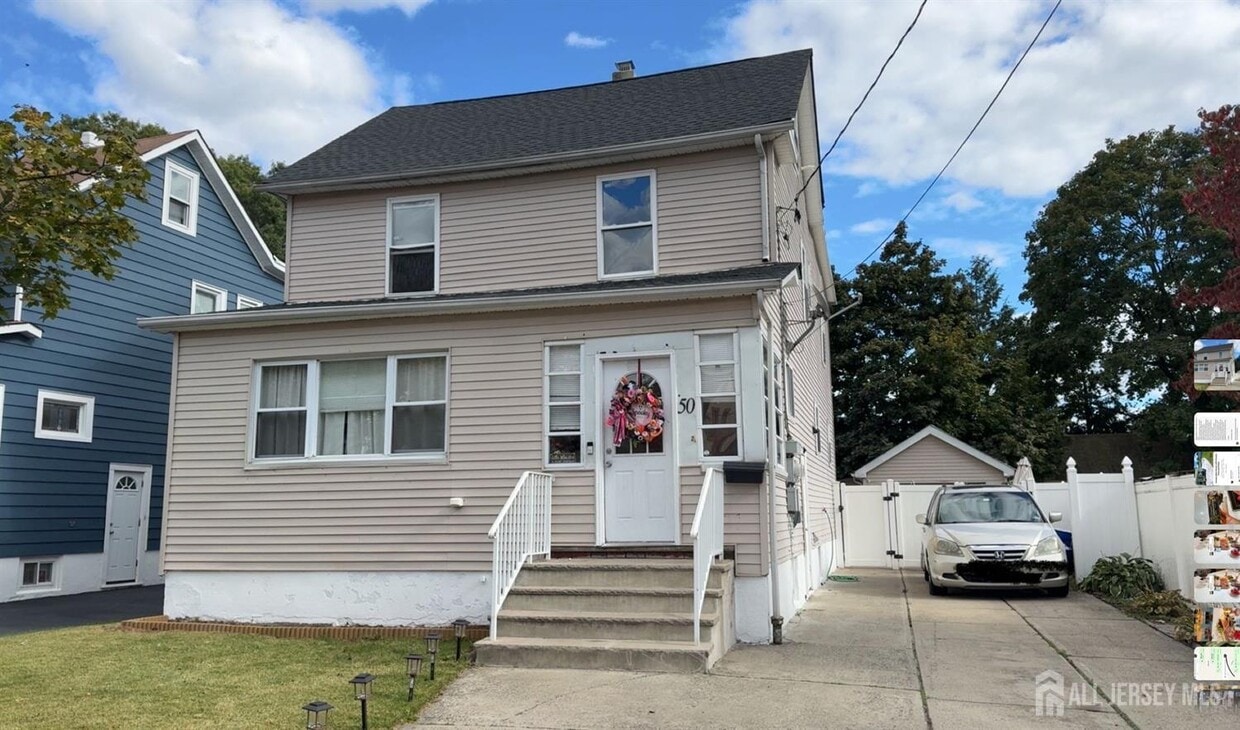
50 Heald St
Carteret, NJ 07008
Today
|
Edit
Favorites
732-442-1400
-
Bedrooms
3
-
Bathrooms
1
-
Square Feet
2,200 sq ft
-
Available
Available Now
Highlights
- Colonial Architecture
- Eat-In Kitchen
- Ceramic Tile Flooring
- Forced Air Heating and Cooling System
- Carpet
- Vinyl Flooring
50 Heald St

Favorites
About This Home
12 Month Lease
,
Available Now
All updated second floor apartment,close to all major highway,shopping,parks,great location in the heart of Carteret a most see to appreciate easy to show. Showing will begin on 10-16-2025
50 Heald St is an apartment community located in Middlesex County and the 07008 ZIP Code.
* Price shown is base rent. Excludes user-selected optional fees and variable or usage-based fees and required charges due at or prior to move-in or at move-out. Price, availability, fees, and any applicable rent special are subject to change without notice.
* Square footage definitions vary. Displayed square footage is approximate.
Home Details
Year Built
Built in 1927
Bedrooms and Bathrooms
1 Full Bathroom
3 Bedrooms
Flooring
Ceramic Tile
Carpet
Vinyl
Home Design
Colonial Architecture
Apartment
Interior Spaces
2,200 Sq Ft Home
2-Story Property
Kitchen
Eat-In Kitchen
Gas Oven or Range
Microwave
Listing and Financial Details
12 Month Lease Term
Tenant pays for electricity, sewer, gas, hot water, water
Lot Details
4,199 Sq Ft Lot
Lot Dimensions are 100.00 x 25.00
Utilities
Forced Air Heating and Cooling System
Gas Water Heater
Underground Utilities
Community Details
Overview
Central Pkwy 01 Subdivision
Pet Policy
No Pets Allowed
Fees and Policies
Details
Lease Options
-
12 Months
Contact
- Listed by MARIA E. OSORIA | PETRA BEST REALTY LLC
- Phone Number
- Contact
-
Source
 CENTRAL JERSEY MULTIPLE LISTING SYSTEM, INC
The CENTRAL JERSEY MULTIPLE LISTING SYSTEM, INC does not warrant the accuracy, quality, reliability, suitability, completeness, usefulness or effectiveness of any information provided. The information being provided is for consumers' personal, non-commercial use and may not be used for any purpose other than to identify properties the consumer may be interested in purchasing or renting. Copyright 2025, CENTRAL JERSEY MULTIPLE LISTING SYSTEM, INC. All rights reserved. “The CENTRAL JERSEY MULTIPLE LISTING SYSTEM, INC retains all rights, title and interest in and to its trademarks, service marks and copyrighted material.
Location
Get Directions
Amenities
- Air Conditioning
- Kitchen
- Microwave
- Oven
- Range
- Refrigerator
- Carpet
- Tile Floors
- Vinyl Flooring
Located directly across the Arthur Kill from Staten Island, Carteret was once part of the Woodbridge Township. It became the borough of Roosevelt in 1906 and was renamed Carteret in 1922. This popular community is bordered by the Rahway River to the north, Arthur Kill to the east, and the Ernest L. Oros Wildlife Preserve to the west. Due to its central location, the borough bills itself as the "Center of it All."
Residents enjoy a fantastic location and beautiful parks. Carteret Waterfront Park has a fishing pier and access to two hiking trails: Danielle's Garden Trail and the Waterfront Fitness Trail. Shopping in Carteret is plentiful -- the brick-paved sidewalks and outdoor cafes along Washington Avenue provide historic charm and locally-owned businesses, while the shops and restaurants along Roosevelt Avenue have a more modern feel. With just 22 miles to Manhattan, 10 miles to Newark, and 70 miles to Philadelphia, residents can easily commute to nearby cities.
Learn more about living in Carteret
Education
| Colleges & Universities | Distance | ||
|---|---|---|---|
| Colleges & Universities | Distance | ||
| Drive: | 14 min | 7.2 mi | |
| Drive: | 17 min | 8.8 mi | |
| Drive: | 18 min | 10.1 mi | |
| Drive: | 23 min | 13.0 mi |
50 Heald St is within 14 minutes or 7.2 miles from Union County Coll., Elizabeth. It is also near Kean University and Coll. of Staten Island, CUNY.
Transportation options available in Carteret include 8Th Street Light Rail Station, located 11.7 miles from 50 Heald St. 50 Heald St is near Newark Liberty International, located 13.3 miles or 21 minutes away, and LaGuardia, located 30.6 miles or 50 minutes away.
| Transit / Subway | Distance | ||
|---|---|---|---|
| Transit / Subway | Distance | ||
| Drive: | 20 min | 11.7 mi | |
|
|
Drive: | 22 min | 12.9 mi |
|
|
Drive: | 21 min | 14.6 mi |
|
|
Drive: | 20 min | 14.6 mi |
| Commuter Rail | Distance | ||
|---|---|---|---|
| Commuter Rail | Distance | ||
|
|
Drive: | 9 min | 3.7 mi |
|
|
Drive: | 9 min | 4.2 mi |
|
|
Drive: | 10 min | 5.1 mi |
|
|
Drive: | 12 min | 6.5 mi |
|
|
Drive: | 22 min | 10.2 mi |
| Airports | Distance | ||
|---|---|---|---|
| Airports | Distance | ||
|
Newark Liberty International
|
Drive: | 21 min | 13.3 mi |
|
LaGuardia
|
Drive: | 50 min | 30.6 mi |
Time and distance from 50 Heald St.
| Shopping Centers | Distance | ||
|---|---|---|---|
| Shopping Centers | Distance | ||
| Walk: | 13 min | 0.7 mi | |
| Walk: | 17 min | 0.9 mi | |
| Drive: | 7 min | 2.4 mi |
50 Heald St has 3 shopping centers within 2.4 miles, which is about a 7-minute walk. The miles and minutes will be for the farthest away property.
| Parks and Recreation | Distance | ||
|---|---|---|---|
| Parks and Recreation | Distance | ||
|
Liberty State Park
|
Drive: | 4 min | 1.8 mi |
|
Hawk Rise Sanctuary
|
Drive: | 11 min | 5.1 mi |
|
Clay Pit Ponds State Park Preserve
|
Drive: | 22 min | 9.7 mi |
|
William T. Davis Wildlife Refuge
|
Drive: | 17 min | 10.3 mi |
|
Freshkills Park
|
Drive: | 23 min | 13.1 mi |
50 Heald St has 5 parks within 13.1 miles, including Liberty State Park, Hawk Rise Sanctuary, and Clay Pit Ponds State Park Preserve.
| Hospitals | Distance | ||
|---|---|---|---|
| Hospitals | Distance | ||
| Drive: | 11 min | 5.1 mi | |
| Drive: | 15 min | 6.7 mi | |
| Drive: | 17 min | 9.4 mi |
50 Heald St has 3 hospitals within 9.4 miles, the nearest is Robert Wood Johnson University Hospital at Rahway which is 5.1 miles away and a 11 minute drive.
| Military Bases | Distance | ||
|---|---|---|---|
| Military Bases | Distance | ||
| Drive: | 19 min | 8.1 mi | |
| Drive: | 22 min | 8.9 mi | |
| Drive: | 27 min | 14.7 mi |
50 Heald St has 3 military bases within 14.7 miles, the nearest is Ash Brook Reservation which is 8.1 miles away and a 19 minute drive.
You May Also Like
How do I access Social Services in New Jersey?
Statewide service is free, confidential, multilingual and always open. Three easy ways to reach Social Services in NJ: Dial 2-1-1; text your zip code to 898-211; or chat at https://www.nj211.org
Similar Rentals Nearby
-
-
-
-
-
-
-
-
-
-
1 / 22


What Are Walk Score®, Transit Score®, and Bike Score® Ratings?
Walk Score® measures the walkability of any address. Transit Score® measures access to public transit. Bike Score® measures the bikeability of any address.
What is a Sound Score Rating?
A Sound Score Rating aggregates noise caused by vehicle traffic, airplane traffic and local sources

50 Heald St
Carteret, NJ 07008