
Presidential Towers
555 W Madison St,
Chicago, IL 60661
$1,627 - $6,277
Studio - 2 Beds
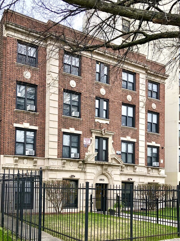

Discover your new home at 4915 S Drexel Apartments. This community is located in the 60615 area of Chicago. Let the knowledgeable leasing staff show you everything this community has to offer. 4915 S Drexel Apartments provides a variety of amenities including: convenient on-site parking options, hardwood floors, and smoke-free options. Contact us today to learn more about our community and make your move to 4915 S Drexel Apartments.
Discover your new home at 4915 S Drexel Apartments. This community is located in the 60615 area of Chicago. Let the knowledgeable leasing staff show you everything this community has to offer. 4915 S Drexel Apartments provides a variety of amenities including: convenient on-site parking options, hardwood floors, and smoke-free options. Contact us today to learn more about our community and make your move to 4915 S Drexel Apartments.
4915 S Drexel Apartments is an apartment community located in Cook County and the 60615 ZIP Code. This area is served by the Chicago Public Schools attendance zone.
Unique Features
Elevator
Controlled Access
Laundry Service
24 Hour Access
Hardwood Floors
Walk-In Closets
Microwave
Refrigerator
Chicago sprawls across roughly 228 square miles on the southwestern shore of Lake Michigan, with nearly 28 miles of lakefront where glass towers catch the morning light and commuter trains rumble through neighborhoods shaped by more than a century of reinvention. This is a city built on bold architecture and bolder ambition, where you can stand beneath the steel ribs of the “L” tracks one moment and find yourself strolling through Grant Park’s open lawns the next.
Renters here choose between classic greystone walk-ups in Lakeview, converted lofts in the West Loop’s Fulton Market district, and sleek high-rises with lake views in Streeterville. Logan Square draws crowds to its Milwaukee Avenue dining scene and the elevated 606 trail, while Lincoln Park offers tree-lined streets near the free zoo. River North packs art galleries alongside bustling restaurants, and Hyde Park anchors the South Side with the Museum of Science and Industry nearby.
Learn more about living in Chicago| Colleges & Universities | Distance | ||
|---|---|---|---|
| Colleges & Universities | Distance | ||
| Drive: | 4 min | 1.6 mi | |
| Drive: | 7 min | 3.0 mi | |
| Drive: | 11 min | 5.5 mi | |
| Drive: | 12 min | 6.1 mi |


Transportation options available in Chicago include 51St Street Station, located 1.0 mile from 4915 S Drexel Apartments. 4915 S Drexel Apartments is near Chicago Midway International, located 8.7 miles or 17 minutes away, and Chicago O'Hare International, located 23.9 miles or 38 minutes away.
| Transit / Subway | Distance | ||
|---|---|---|---|
| Transit / Subway | Distance | ||
|
|
Walk: | 18 min | 1.0 mi |
|
|
Walk: | 22 min | 1.1 mi |
|
|
Drive: | 4 min | 1.6 mi |
|
|
Drive: | 3 min | 1.6 mi |
|
|
Drive: | 4 min | 2.1 mi |
| Commuter Rail | Distance | ||
|---|---|---|---|
| Commuter Rail | Distance | ||
|
|
Walk: | 18 min | 1.0 mi |
|
|
Drive: | 3 min | 1.4 mi |
|
|
Drive: | 4 min | 1.9 mi |
|
|
Drive: | 6 min | 2.6 mi |
|
|
Drive: | 6 min | 2.8 mi |
| Airports | Distance | ||
|---|---|---|---|
| Airports | Distance | ||
|
Chicago Midway International
|
Drive: | 17 min | 8.7 mi |
|
Chicago O'Hare International
|
Drive: | 38 min | 23.9 mi |
Scores provided by
Traffic
-Airport
-Businesses
-Scores provided by
HowLoud What is a Sound Score Rating? A Sound Score Rating aggregates noise caused by vehicle traffic, airplane traffic and local sources. How It WorksTime and distance from 4915 S Drexel Apartments.
| Shopping Centers | Distance | ||
|---|---|---|---|
| Shopping Centers | Distance | ||
| Walk: | 4 min | 0.3 mi | |
| Walk: | 6 min | 0.4 mi | |
| Walk: | 11 min | 0.6 mi |
| Parks and Recreation | Distance | ||
|---|---|---|---|
| Parks and Recreation | Distance | ||
|
Washington Park
|
Drive: | 3 min | 1.6 mi |
|
Ellis Park
|
Drive: | 3 min | 1.7 mi |
|
Midway Plaisance Park
|
Drive: | 4 min | 1.8 mi |
|
Fuller Park
|
Drive: | 5 min | 2.1 mi |
|
Museum of Science and Industry
|
Drive: | 5 min | 2.2 mi |
| Hospitals | Distance | ||
|---|---|---|---|
| Hospitals | Distance | ||
| Walk: | 14 min | 0.7 mi | |
| Drive: | 3 min | 1.5 mi | |
| Drive: | 7 min | 3.5 mi |
| Military Bases | Distance | ||
|---|---|---|---|
| Military Bases | Distance | ||
| Drive: | 46 min | 31.6 mi | |
| Drive: | 53 min | 35.3 mi | |
| Drive: | 63 min | 40.3 mi |

4915 S Drexel Blvd
Chicago, IL 60615


