
$2,900
/ Month
48 N Whittier St Unit 2
Carteret, NJ 07008
2 Weeks Ago
Favorites
48 N Whittier St Unit 2

Favorites
Check Back Soon for Upcoming Availability
| Beds | Baths | Average SF |
|---|---|---|
| 3 Bedrooms 3 Bedrooms 3 Br | 2 Baths 2 Baths 2 Ba | 1,500 SF |
Fees and Policies
The fees below are based on community-supplied data and may exclude additional fees and utilities.
- Parking
-
Street--
Details
Utilities Included
-
Trash Removal
-
Sewer
Property Information
-
2 units
About This Property
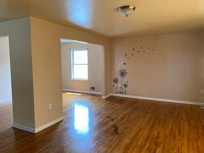
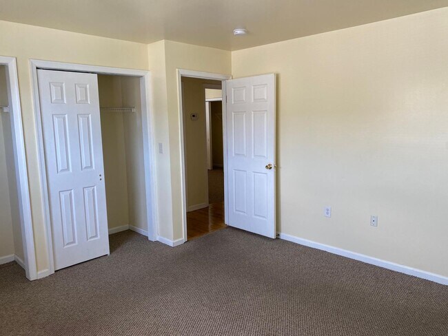
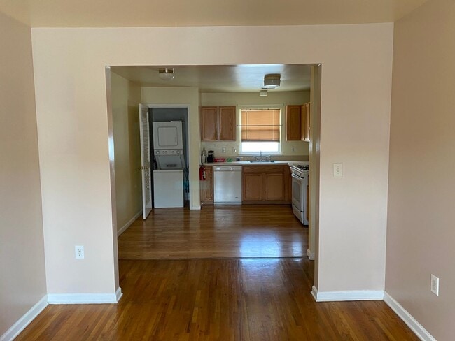
Beautiful 3 bedroom and 2 full bathroom apartment in Carteret, NJ. The apartment has 3 spacious bedrooms, a large living room, 2 full bathrooms, kitchen with a built in laundry, and a dining room. There are large windows which offer great natural lighting. The apartment is 3 blocks from the 48 and 116 NJ Transit buses which connect directly to Port Authority (NYC). The apartment also features its own individual and up-to-date AC/Heating units. No smoking and no pets allowed.
48 N Whittier St is an apartment community located in Middlesex County and the 07008 ZIP Code.
Apartment Features
Washer/Dryer
Air Conditioning
Dishwasher
Hardwood Floors
Refrigerator
Tub/Shower
Tile Floors
Smoke Free
Highlights
- Washer/Dryer
- Air Conditioning
- Heating
- Smoke Free
- Cable Ready
- Tub/Shower
- Handrails
Kitchen Features & Appliances
- Dishwasher
- Eat-in Kitchen
- Kitchen
- Oven
- Refrigerator
- Instant Hot Water
Model Details
- Hardwood Floors
- Carpet
- Tile Floors
- Dining Room
- Den
- Linen Closet
- Large Bedrooms
Location
Get Directions
Located directly across the Arthur Kill from Staten Island, Carteret was once part of the Woodbridge Township. It became the borough of Roosevelt in 1906 and was renamed Carteret in 1922. This popular community is bordered by the Rahway River to the north, Arthur Kill to the east, and the Ernest L. Oros Wildlife Preserve to the west. Due to its central location, the borough bills itself as the "Center of it All."
Residents enjoy a fantastic location and beautiful parks. Carteret Waterfront Park has a fishing pier and access to two hiking trails: Danielle's Garden Trail and the Waterfront Fitness Trail. Shopping in Carteret is plentiful -- the brick-paved sidewalks and outdoor cafes along Washington Avenue provide historic charm and locally-owned businesses, while the shops and restaurants along Roosevelt Avenue have a more modern feel. With just 22 miles to Manhattan, 10 miles to Newark, and 70 miles to Philadelphia, residents can easily commute to nearby cities.
Learn more about living in Carteret
Amenities
- Washer/Dryer
- Air Conditioning
- Heating
- Smoke Free
- Cable Ready
- Tub/Shower
- Handrails
- Dishwasher
- Eat-in Kitchen
- Kitchen
- Oven
- Refrigerator
- Instant Hot Water
- Hardwood Floors
- Carpet
- Tile Floors
- Dining Room
- Den
- Linen Closet
- Large Bedrooms
Expenses
Utilities Included
Trash Removal, Sewer
Included
Education
| Colleges & Universities | Distance | ||
|---|---|---|---|
| Colleges & Universities | Distance | ||
| Drive: | 14 min | 7.2 mi | |
| Drive: | 18 min | 8.9 mi | |
| Drive: | 19 min | 10.1 mi | |
| Drive: | 23 min | 13.1 mi |
48 N Whittier St Unit 2 is within 14 minutes or 7.2 miles from Union County Coll., Elizabeth. It is also near Kean University and Coll. of Staten Island, CUNY.
Transportation options available in Carteret include 8Th Street Light Rail Station, located 11.7 miles from 48 N Whittier St Unit 2. 48 N Whittier St Unit 2 is near Newark Liberty International, located 13.3 miles or 22 minutes away, and LaGuardia, located 30.7 miles or 51 minutes away.
| Transit / Subway | Distance | ||
|---|---|---|---|
| Transit / Subway | Distance | ||
| Drive: | 20 min | 11.7 mi | |
|
|
Drive: | 22 min | 12.9 mi |
|
|
Drive: | 21 min | 14.6 mi |
|
|
Drive: | 20 min | 14.6 mi |
| Commuter Rail | Distance | ||
|---|---|---|---|
| Commuter Rail | Distance | ||
|
|
Drive: | 9 min | 3.7 mi |
|
|
Drive: | 9 min | 4.2 mi |
|
|
Drive: | 10 min | 5.1 mi |
|
|
Drive: | 22 min | 10.2 mi |
|
|
Drive: | 23 min | 11.6 mi |
| Airports | Distance | ||
|---|---|---|---|
| Airports | Distance | ||
|
Newark Liberty International
|
Drive: | 22 min | 13.3 mi |
|
LaGuardia
|
Drive: | 51 min | 30.7 mi |
Time and distance from 48 N Whittier St Unit 2.
| Shopping Centers | Distance | ||
|---|---|---|---|
| Shopping Centers | Distance | ||
| Walk: | 15 min | 0.8 mi | |
| Walk: | 18 min | 1.0 mi | |
| Drive: | 17 min | 10.3 mi |
48 N Whittier St Unit 2 has 3 shopping centers within 10.3 miles, which is about a 17-minute walk. The miles and minutes will be for the farthest away property.
| Parks and Recreation | Distance | ||
|---|---|---|---|
| Parks and Recreation | Distance | ||
|
Liberty State Park
|
Drive: | 5 min | 1.8 mi |
|
Hawk Rise Sanctuary
|
Drive: | 12 min | 5.2 mi |
|
Clay Pit Ponds State Park Preserve
|
Drive: | 22 min | 9.7 mi |
|
William T. Davis Wildlife Refuge
|
Drive: | 18 min | 10.3 mi |
|
Freshkills Park
|
Drive: | 24 min | 13.2 mi |
48 N Whittier St Unit 2 has 5 parks within 13.2 miles, including Liberty State Park, Hawk Rise Sanctuary, and Clay Pit Ponds State Park Preserve.
| Hospitals | Distance | ||
|---|---|---|---|
| Hospitals | Distance | ||
| Drive: | 12 min | 5.2 mi | |
| Drive: | 15 min | 6.7 mi | |
| Drive: | 17 min | 9.4 mi |
48 N Whittier St Unit 2 has 3 hospitals within 9.4 miles, the nearest is Robert Wood Johnson University Hospital at Rahway which is 5.2 miles away and a 12 minute drive.
| Military Bases | Distance | ||
|---|---|---|---|
| Military Bases | Distance | ||
| Drive: | 19 min | 8.1 mi | |
| Drive: | 22 min | 8.9 mi | |
| Drive: | 27 min | 14.7 mi |
48 N Whittier St Unit 2 has 3 military bases within 14.7 miles, the nearest is Ash Brook Reservation which is 8.1 miles away and a 19 minute drive.
You May Also Like
Similar Rentals Nearby


What Are Walk Score®, Transit Score®, and Bike Score® Ratings?
Walk Score® measures the walkability of any address. Transit Score® measures access to public transit. Bike Score® measures the bikeability of any address.
What is a Sound Score Rating?
A Sound Score Rating aggregates noise caused by vehicle traffic, airplane traffic and local sources

48 N Whittier St
Carteret, NJ 07008