
$2,450
Total Monthly Price
466 Commercial Street
Boston, MA 02109
2 Weeks Ago
|
Edit
Favorites
466 Commercial Street

Favorites
Check Back Soon for Upcoming Availability
| Beds | Baths | Average SF |
|---|---|---|
| 2 Bedrooms 2 Bedrooms 2 Br | 1 Bath 1 Bath 1 Ba | — |
About This Property
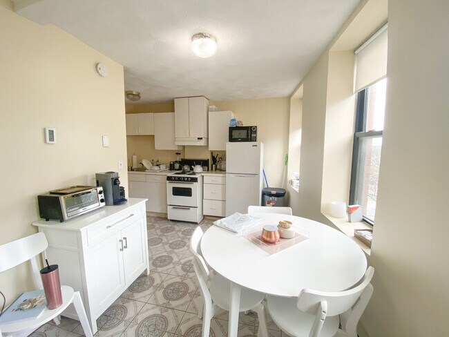
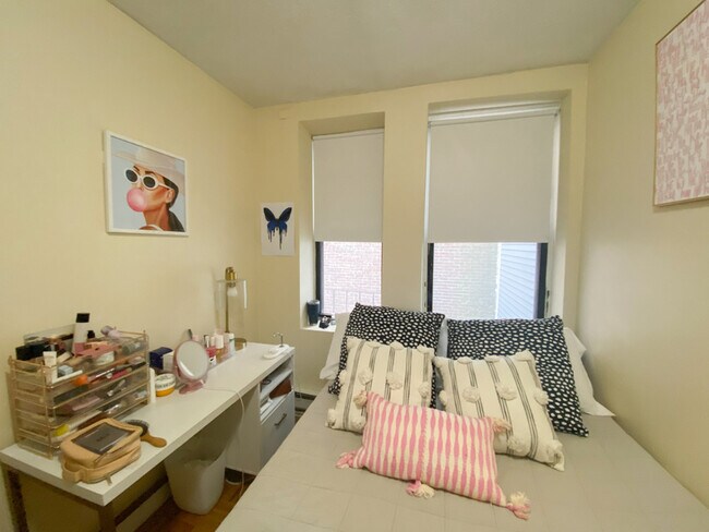
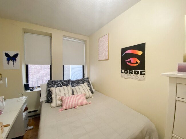
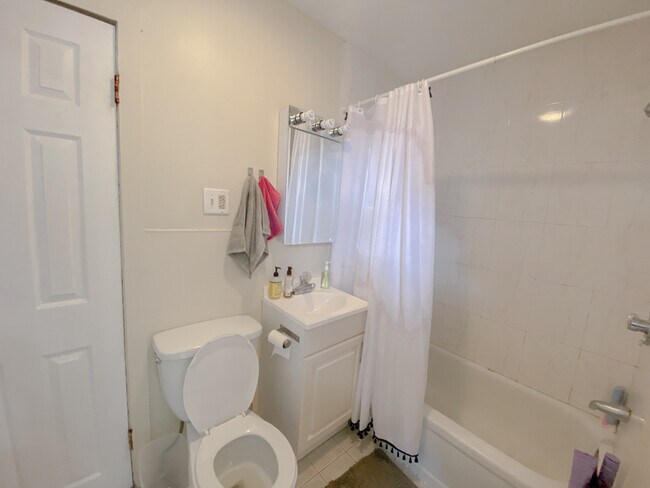
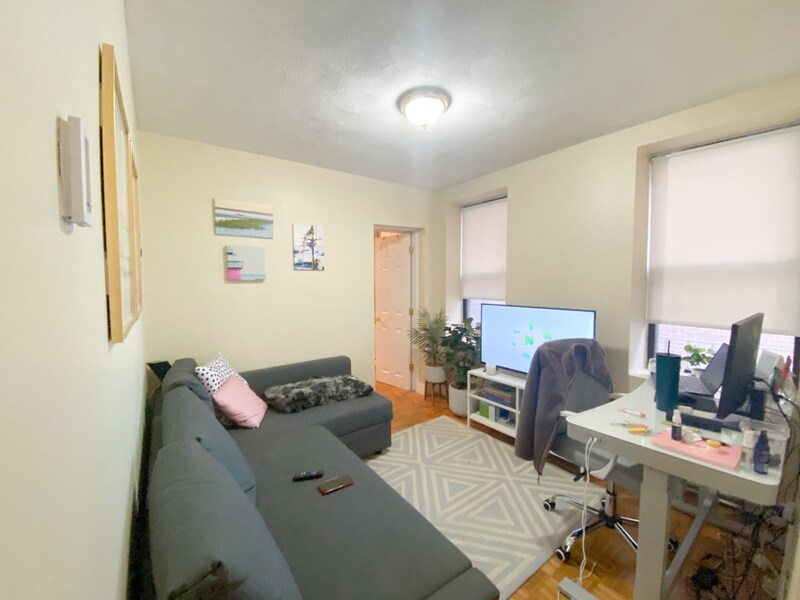
This 2 bedroom features a large eat in kitchen, 2 bedrooms with ample closet space, water views, new laundry facilities. Convenient downtown location directly across is several baseball fields, basketball courts, a playground, Bocce courts and a pool.
466 Commercial Street is a condo located in Suffolk County and the 02109 ZIP Code. This area is served by the Boston Public Schools attendance zone.
466 Commercial Street,
Boston,
MA
02109
The North End of Boston occupies the northeastern corner of the city beyond Washington Street and Columbus Circle. It is the city’s oldest residential neighborhood and comes with a rich history. Boston’s “Little Italy” has undergone some serious growth and modernization over the decades. Once home to revolutionary heroes such as Paul Revere, the area now draws new residents, young professionals, retirees, and tourists. Residents’ pride in this neighborhood is almost tangible – locals love North End and show it every summer during Feast season, a few weeks span of parades, music, dancing, and street food, all in celebration of North End and historic Italian Saints.
While this neighborhood is admittedly very tourist-heavy, the resulting revenue keeps the economy booming. Residents are still able to live, work, and play like normal. North End is less than a mile from Downtown Boston, making work commutes a breeze.
Learn more about living in North End BostonBelow are rent ranges for similar nearby apartments
| Beds | Average Size | Lowest | Typical | Premium |
|---|---|---|---|---|
| Studio Studio Studio | 3245 Sq Ft | $2,250 | $2,963 | $7,050 |
| 1 Bed 1 Bed 1 Bed | 3274 Sq Ft | $1,600 | $3,357 | $9,397 |
| 2 Beds 2 Beds 2 Beds | 4050 Sq Ft | $2,500 | $4,025 | $13,590 |
| 3 Beds 3 Beds 3 Beds | 4775 Sq Ft | $1,410 | $5,239 | $20,000 |
| 4 Beds 4 Beds 4 Beds | 3941 Sq Ft | $1,410 | $5,845 | $7,800 |
Education
| Colleges & Universities | Distance | ||
|---|---|---|---|
| Colleges & Universities | Distance | ||
| Drive: | 3 min | 1.1 mi | |
| Drive: | 5 min | 1.6 mi | |
| Drive: | 5 min | 2.1 mi | |
| Drive: | 5 min | 2.2 mi |
466 Commercial Street is within 3 minutes or 1.1 miles from Suffolk University. It is also near Bunker Hill Community College and Emerson College.
Schools


Public Elementary & Middle School
Grades PK-8
779 Students
Nearby
Public Middle & High School
Grades 6-12
646 Students
Nearby
Private Elementary & Middle School
Grades PK-8
224 Students
Nearby
Private High School
Grades 9-12
24 Students
Nearby
School data provided by
 The GreatSchools Rating helps parents compare schools within a state based on a variety of school quality indicators and provides a helpful picture of how effectively each school serves all of its students. Ratings are on a scale of 1 (below average) to 10 (above average) and can include test scores, college readiness, academic progress, advanced courses, equity, discipline and attendance data. We also advise parents to visit schools, consider other information on school performance and programs, and consider family needs as part of the school selection process.
View GreatSchools Rating Methodology
Data provided by GreatSchools.org © 2026. All rights reserved.
View GreatSchools Rating Methodology
Data provided by GreatSchools.org © 2026. All rights reserved.
Transportation options available in Boston include Haymarket Station, located 0.5 mile from 466 Commercial Street. 466 Commercial Street is near General Edward Lawrence Logan International, located 3.5 miles or 8 minutes away.
| Transit / Subway | Distance | ||
|---|---|---|---|
| Transit / Subway | Distance | ||
|
|
Walk: | 9 min | 0.5 mi |
|
|
Walk: | 9 min | 0.5 mi |
|
|
Walk: | 13 min | 0.7 mi |
|
|
Walk: | 14 min | 0.8 mi |
|
|
Walk: | 15 min | 0.8 mi |
| Commuter Rail | Distance | ||
|---|---|---|---|
| Commuter Rail | Distance | ||
|
|
Walk: | 11 min | 0.6 mi |
|
|
Drive: | 3 min | 1.6 mi |
|
|
Drive: | 9 min | 2.9 mi |
| Drive: | 8 min | 3.5 mi | |
|
|
Drive: | 11 min | 6.6 mi |
| Airports | Distance | ||
|---|---|---|---|
| Airports | Distance | ||
|
General Edward Lawrence Logan International
|
Drive: | 8 min | 3.5 mi |
Walkability Near 466 Commercial Street Boston, MA 02109
Getting Around
 What do Walkability, Transit, Drivability, and Bikeability mean?
Walkability measures the walking distance to day-to-day needs.
Transit measures access to public transportation.
Drivability measures congestion, parking availability, and access to major roads.
Bikeability measures the suitability for cycling.
How It Works
What do Walkability, Transit, Drivability, and Bikeability mean?
Walkability measures the walking distance to day-to-day needs.
Transit measures access to public transportation.
Drivability measures congestion, parking availability, and access to major roads.
Bikeability measures the suitability for cycling.
How It Works
Exceptionally Walkable
Walkability
100
/ 100
Exceptional Public Transit
Transit
100
/ 100
Moderately Drivable
Drivability
60
/ 100
Very Bikeable
Bikeability
80
/ 100
Scores provided by
-
Soundscore™
-
/ 100
Traffic
-Airport
-Businesses
-Scores provided by
HowLoud What is a Sound Score Rating? A Sound Score Rating aggregates noise caused by vehicle traffic, airplane traffic and local sources. How It WorksTime and distance from 466 Commercial Street.
| Shopping Centers | Distance | ||
|---|---|---|---|
| Shopping Centers | Distance | ||
| Walk: | 9 min | 0.5 mi | |
| Walk: | 12 min | 0.6 mi | |
| Walk: | 13 min | 0.7 mi |
466 Commercial Street has 3 shopping centers within 0.7 mile, which is about a 13-minute walk. The miles and minutes will be for the farthest away property.
| Parks and Recreation | Distance | ||
|---|---|---|---|
| Parks and Recreation | Distance | ||
|
Boston National Historical Park
|
Walk: | 12 min | 0.6 mi |
|
New England Aquarium
|
Walk: | 16 min | 0.8 mi |
|
Museum of Science
|
Drive: | 5 min | 1.3 mi |
|
Boston African American National Historic Site
|
Drive: | 4 min | 1.3 mi |
|
Boston Harbor Islands National Recreation Area
|
Drive: | 3 min | 1.3 mi |
466 Commercial Street has 5 parks within 1.3 miles, including Boston National Historical Park, New England Aquarium, and Boston African American National Historic Site.
| Hospitals | Distance | ||
|---|---|---|---|
| Hospitals | Distance | ||
| Drive: | 3 min | 1.1 mi | |
| Drive: | 3 min | 1.2 mi | |
| Drive: | 4 min | 1.3 mi |
466 Commercial Street has 3 hospitals within 1.3 miles, the nearest is Shriners Hospital for Children - Boston which is 1.1 miles away and a 3 minute drive.
| Military Bases | Distance | ||
|---|---|---|---|
| Military Bases | Distance | ||
| Drive: | 29 min | 15.8 mi | |
| Drive: | 30 min | 18.3 mi |
466 Commercial Street is 15.8 miles from Hanscom Air Force Base, and is convenient to other military bases, including Fort Miller.
You May Also Like
Similar Rentals Nearby


What Are Walk Score®, Transit Score®, and Bike Score® Ratings?
Walk Score® measures the walkability of any address. Transit Score® measures access to public transit. Bike Score® measures the bikeability of any address.
What is a Sound Score Rating?
A Sound Score Rating aggregates noise caused by vehicle traffic, airplane traffic and local sources.
466 Commercial Street
Boston, MA 02109