
$2,495
/ Month
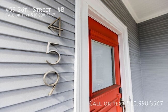
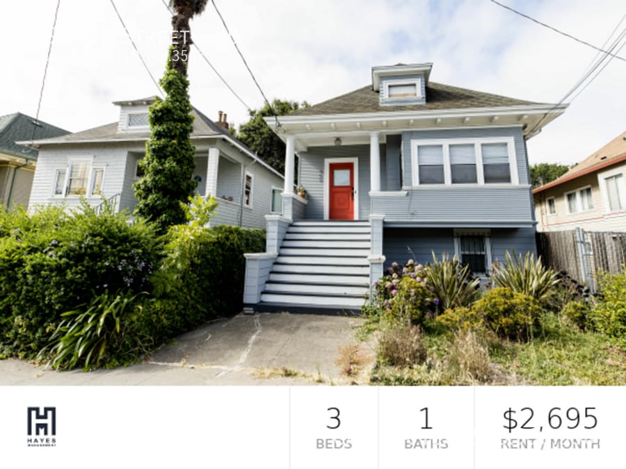
459 36th St Unit #B
Oakland, CA 94609
Today
|
Edit
Favorites
510-998-3567
-
Bedrooms
3
-
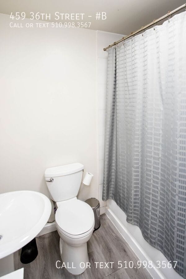
Bathrooms
1
-
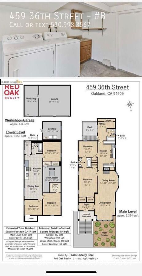
Square Feet
1,053 sq ft
-
Available
Available May 2
459 36th St Unit #B

Favorites
About This Home
Available May 2
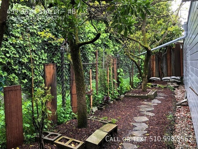
Beautiful lower unit of duplex, within standalone house. Sizable yard, great for entertaining. 10 minute walk to MacArthur BART and 3 great neighborhoods Temescal (Burma Superstar, Temescal Alley!), Broadway, and Piedmont. Walkable to Uptown. House - Approximately 1053 sq ft house + laundry space - 3 bedrooms - 1 bathrooms - 1053 finished sq footage - Plus 150 sq ft laundry room (shared) - Back deck and large front porch - Backyard nice for parking Neighborhood - Lower Temescal neighborhood near Mosswood Park - 3 min walk to: Community yoga, Korea gastropub (open till 1:30am), mini marts and small produce store - Telegraph Ave Temescal has tons of shops - Shops on Broadway (e.g. Brenda’s!) and Piedmont Streets - 10 min walk to MacArthur BART, 6 Bus to both Berkeley campus and Uptown Oakland $2,495 based on receiving 2 months free rent. The list price is $2,994.
459 36th St is an apartment community located in Alameda County and the 94609 ZIP Code.
* Price shown is base rent. Excludes user-selected optional fees and variable or usage-based fees and required charges due at or prior to move-in or at move-out. Price, availability, fees, and any applicable rent special are subject to change without notice.
* Square footage definitions vary. Displayed square footage is approximate.
Fees and Policies
The fees listed below are community-provided and may exclude utilities or add-ons. All payments are made directly to the property and are non-refundable unless otherwise specified.
-
Dogs
-
Allowed
-
-
Cats
-
Allowed
-
Property Fee Disclaimer: Based on community-supplied data and independent market research. Subject to change without notice. May exclude fees for mandatory or optional services and usage-based utilities.
Contact
- Listed by Sam Hayes
- Phone Number
- Contact
Location
Get Directions
Conveniently positioned in North Oakland at the junction of Interstates 580 and 980, Mosswood is a delightful neighborhood with a quirky personality. The community is mainly residential, with a full network of tree-lined sidewalks allowing residents to walk to the neighborhood’s various shops and cafes with ease.
On the southeast corner of the neighborhood, Mosswood Park is a terrific place to unwind, with playgrounds, sports fields, and a popular community amphitheater. Several branches of the Kaiser Permanente Medical Center are located within easy walking distance of the neighborhood, making Mosswood a highly convenient place for healthcare professionals to live.
Learn more about living in Mosswood
Education
| Colleges & Universities | Distance | ||
|---|---|---|---|
| Colleges & Universities | Distance | ||
| Drive: | 4 min | 1.5 mi | |
| Drive: | 5 min | 2.2 mi | |
| Drive: | 6 min | 3.7 mi | |
| Drive: | 9 min | 4.2 mi |
459 36th St Unit #B is within 4 minutes or 1.5 miles from Samuel Merritt University. It is also near Lincoln University, Oakland and Laney College.
Transportation options available in Oakland include 19Th Street Oakland, located 1.6 miles from 459 36th St Unit #B. 459 36th St Unit #B is near Metro Oakland International, located 11.2 miles or 17 minutes away, and San Francisco International, located 23.0 miles or 35 minutes away.
| Transit / Subway | Distance | ||
|---|---|---|---|
| Transit / Subway | Distance | ||
|
|
Drive: | 3 min | 1.6 mi |
|
|
Drive: | 4 min | 2.0 mi |
|
|
Drive: | 5 min | 3.1 mi |
|
|
Drive: | 7 min | 3.5 mi |
|
|
Drive: | 7 min | 4.1 mi |
| Commuter Rail | Distance | ||
|---|---|---|---|
| Commuter Rail | Distance | ||
|
|
Drive: | 5 min | 2.9 mi |
| Drive: | 8 min | 4.0 mi | |
|
|
Drive: | 9 min | 5.6 mi |
| Drive: | 17 min | 10.6 mi | |
| Drive: | 18 min | 11.8 mi |
| Airports | Distance | ||
|---|---|---|---|
| Airports | Distance | ||
|
Metro Oakland International
|
Drive: | 17 min | 11.2 mi |
|
San Francisco International
|
Drive: | 35 min | 23.0 mi |
Getting Around
 What do Walkability, Transit, Drivability, and Bikeability mean?
Walkability measures the walking distance to day-to-day needs.
Transit measures access to public transportation.
Drivability measures congestion, parking availability, and access to major roads.
Bikeability measures the suitability for cycling.
How It Works
What do Walkability, Transit, Drivability, and Bikeability mean?
Walkability measures the walking distance to day-to-day needs.
Transit measures access to public transportation.
Drivability measures congestion, parking availability, and access to major roads.
Bikeability measures the suitability for cycling.
How It Works
Moderately Walkable
Walkability
60
/ 100
Strong Public Transit
Transit
80
/ 100
Exceptionally Drivable
Drivability
100
/ 100
Not Bikeable
Bikeability
0
/ 100
Scores provided by
Busy
Soundscore™
60
/ 100
Traffic
BusyAirport
CalmBusinesses
BusyScores provided by
HowLoud What is a Sound Score Rating? A Sound Score Rating aggregates noise caused by vehicle traffic, airplane traffic and local sources. How It WorksTime and distance from 459 36th St Unit #B.
| Shopping Centers | Distance | ||
|---|---|---|---|
| Shopping Centers | Distance | ||
| Drive: | 4 min | 1.7 mi | |
| Drive: | 4 min | 1.9 mi | |
| Drive: | 4 min | 2.2 mi |
459 36th St Unit #B has 3 shopping centers within 2.2 miles, which is about a 4-minute drive. The miles and minutes will be for the farthest away property.
| Parks and Recreation | Distance | ||
|---|---|---|---|
| Parks and Recreation | Distance | ||
|
Lakeside Park Garden Center
|
Drive: | 4 min | 1.9 mi |
|
Lakeside Park
|
Drive: | 4 min | 2.2 mi |
|
Rotary Nature Center
|
Drive: | 5 min | 2.3 mi |
|
Juan Bautista de Anza National Historic Trail
|
Drive: | 4 min | 2.5 mi |
|
Morcom Rose Garden
|
Drive: | 6 min | 2.7 mi |
459 36th St Unit #B has 5 parks within 2.7 miles, including Morcom Rose Garden, Lakeside Park Garden Center, and Rotary Nature Center.
| Hospitals | Distance | ||
|---|---|---|---|
| Hospitals | Distance | ||
| Drive: | 4 min | 1.5 mi | |
| Drive: | 4 min | 2.2 mi | |
| Drive: | 4 min | 2.3 mi |
459 36th St Unit #B has 3 hospitals within 2.3 miles, the nearest is Alta Bates Summit Medical Center which is 1.5 miles away and a 4 minute drive.
| Military Bases | Distance | ||
|---|---|---|---|
| Military Bases | Distance | ||
| Drive: | 12 min | 4.7 mi | |
| Drive: | 13 min | 5.7 mi |
459 36th St Unit #B is 4.7 miles from Oakland Army Base, and is convenient to other military bases, including Alameda/US Naval Air Station Alameda.
You May Also Like
Similar Rentals Nearby
-
-
3 Beds$4,326+Total Monthly PriceTotal Monthly Price NewPrices include base rent and required monthly fees of $6. Variable costs based on usage may apply.Base Rent:3 Beds$4,320+2 Months Free
Pets Allowed Fitness Center Pool In Unit Washer & Dryer Clubhouse Stainless Steel Appliances Hardwood Floors
-
-
-
-
-
-
-
-


What Are Walk Score®, Transit Score®, and Bike Score® Ratings?
Walk Score® measures the walkability of any address. Transit Score® measures access to public transit. Bike Score® measures the bikeability of any address.
What is a Sound Score Rating?
A Sound Score Rating aggregates noise caused by vehicle traffic, airplane traffic and local sources.
459 36th St
Oakland, CA 94609