

$916 / Month
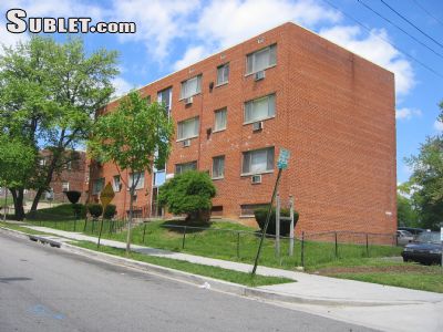
4452 B St SE
Washington, DC 20019
2 Weeks Ago
Favorites
4452 B St SE

Favorites
Check Back Soon for Upcoming Availability
| Beds | Baths | Average SF |
|---|---|---|
| 1 Bedroom 1 Bedroom 1 Br | 1 Bath 1 Bath 1 Ba | — |
About This Property
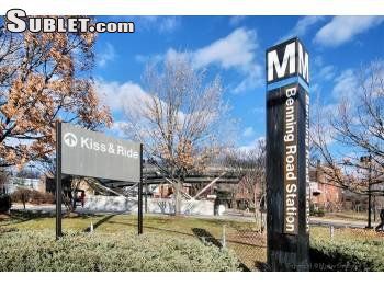
Sublet.com ID 2649792. B Street Apartments ** $916 AIR CONDITIONED TWO BEDROOM $916 ** Benning Road Metro B Street, South East, Washington DC. Very Large Renovated and Air Conditioned One Bedroom Apartment. Free off street parking and on site laundry facilities. Located a short walk to the Benning Road Orange / Blue Metro Line Metro-rail stations and Metro Bus stops at properties. On the East Capitol Street corridor with easy access to downtown Washington DC and Prince Georges County. Just minutes to major highways I-95, I-295, R-50, and I-495, Central, New York, and Kenilworth Avenues, the neighborhood offers superior regional access B Street, South East, Washington DC (Benning Metro Station) ***Apartment #302 now available $916*** Features Renovated Apartments Walk to Benning Metro Station Air Conditioned 24-Hour Maintenance Laundry On-Site Parking - Free Parking - Off-street Hardwood Floors High-Speed internet ready Cable ready Large closets Large apa For more details and images visit sublet.com/rhp.asp and enter ID 2649792
4452 B St SE is a condo located in District of Columbia County and the 20019 ZIP Code. This area is served by the District Of Columbia Public Schools attendance zone.
Location
Get Directions
The residential neighborhood of Fort Dupont sits just east of the Anacostia River in Southeast Washington, DC. The neighborhood has ample green space provided by two adjacent parks — Fort Circle Park and Fort Chaplin Park — and distinguishes itself within the Greater Anacostia area by housing the only public indoor ice rink in Washington, DC.
There’s a diverse mix of rentals in Fort Dupont, from more recent and upscale developments to long-standing apartment homes closer to the Anacostia River. Proximity to the Benning Road Metro Station makes Fort Dupont perfect for the Capitol Hill commuter who wishes to reside outside the bustle of DC.
Learn more about living in Fort DupontBelow are rent ranges for similar nearby apartments
Education
| Colleges & Universities | Distance | ||
|---|---|---|---|
| Colleges & Universities | Distance | ||
| Drive: | 8 min | 3.9 mi | |
| Drive: | 8 min | 4.8 mi | |
| Drive: | 8 min | 4.8 mi | |
| Drive: | 11 min | 5.9 mi |
4452 B St SE is within 8 minutes or 3.9 miles from Gallaudet University. It is also near Georgetown and Georgetown Law.
Schools


Public Elementary School
Grades PK-5
203 Students
Attendance Zone
Public Middle School
Grades 6-8
351 Students
Attendance Zone
Charter High School
Grades 9-12
248 Students
Nearby
Public High School
Grades 9-12
865 Students
Attendance Zone
Private Elementary, Middle & High School
Grades PK-12
149 Students
Nearby
School data provided by
 The GreatSchools Rating helps parents compare schools within a state based on a variety of school quality indicators and provides a helpful picture of how effectively each school serves all of its students. Ratings are on a scale of 1 (below average) to 10 (above average) and can include test scores, college readiness, academic progress, advanced courses, equity, discipline and attendance data. We also advise parents to visit schools, consider other information on school performance and programs, and consider family needs as part of the school selection process.
View GreatSchools Rating Methodology
Data provided by GreatSchools.org © 2025. All rights reserved.
View GreatSchools Rating Methodology
Data provided by GreatSchools.org © 2025. All rights reserved.
Transportation options available in Washington include Benning Road, located 0.3 mile from 4452 B St SE. 4452 B St SE is near Ronald Reagan Washington Ntl, located 10.3 miles or 18 minutes away, and Baltimore/Washington International Thurgood Marshall, located 28.8 miles or 43 minutes away.
| Transit / Subway | Distance | ||
|---|---|---|---|
| Transit / Subway | Distance | ||
|
|
Walk: | 6 min | 0.3 mi |
|
|
Drive: | 3 min | 1.6 mi |
|
Capitol Heights, Blue/Silver Line Center Platform
|
Drive: | 5 min | 1.8 mi |
|
|
Drive: | 5 min | 2.0 mi |
| Drive: | 3 min | 2.1 mi |
| Commuter Rail | Distance | ||
|---|---|---|---|
| Commuter Rail | Distance | ||
|
|
Drive: | 7 min | 4.1 mi |
|
|
Drive: | 8 min | 4.3 mi |
|
|
Drive: | 10 min | 5.6 mi |
|
|
Drive: | 10 min | 5.6 mi |
|
|
Drive: | 13 min | 6.6 mi |
| Airports | Distance | ||
|---|---|---|---|
| Airports | Distance | ||
|
Ronald Reagan Washington Ntl
|
Drive: | 18 min | 10.3 mi |
|
Baltimore/Washington International Thurgood Marshall
|
Drive: | 43 min | 28.8 mi |
Time and distance from 4452 B St SE.
| Shopping Centers | Distance | ||
|---|---|---|---|
| Shopping Centers | Distance | ||
| Walk: | 4 min | 0.2 mi | |
| Walk: | 17 min | 0.9 mi | |
| Walk: | 18 min | 0.9 mi |
4452 B St SE has 3 shopping centers within 0.9 mile, which is about a 18-minute walk. The miles and minutes will be for the farthest away property.
| Parks and Recreation | Distance | ||
|---|---|---|---|
| Parks and Recreation | Distance | ||
|
Fort Dupont Park
|
Drive: | 4 min | 1.2 mi |
|
Kingman and Heritage Island Park
|
Drive: | 3 min | 2.1 mi |
|
Washington Youth Garden
|
Drive: | 6 min | 3.6 mi |
|
Frederick Douglass National Historic Site
|
Drive: | 10 min | 4.1 mi |
|
National Arboretum
|
Drive: | 10 min | 4.3 mi |
4452 B St SE has 5 parks within 4.3 miles, including Fort Dupont Park, Kingman and Heritage Island Park, and Washington Youth Garden.
| Hospitals | Distance | ||
|---|---|---|---|
| Hospitals | Distance | ||
| Drive: | 8 min | 4.0 mi | |
| Drive: | 13 min | 4.9 mi | |
| Drive: | 13 min | 5.4 mi |
4452 B St SE has 3 hospitals within 5.4 miles, the nearest is University of Maryland Prince George's Hospital Center which is 4.0 miles away and a 8 minute drive.
| Military Bases | Distance | ||
|---|---|---|---|
| Military Bases | Distance | ||
| Drive: | 9 min | 4.4 mi | |
| Drive: | 12 min | 6.6 mi |
4452 B St SE is 4.4 miles from Washington Navy Yard, and is convenient to other military bases, including Anacostia Naval Station.
You May Also Like
Similar Rentals Nearby
-
-

-

-

-

-

-

-
-
1 / 36

-
1 / 22


What Are Walk Score®, Transit Score®, and Bike Score® Ratings?
Walk Score® measures the walkability of any address. Transit Score® measures access to public transit. Bike Score® measures the bikeability of any address.
What is a Sound Score Rating?
A Sound Score Rating aggregates noise caused by vehicle traffic, airplane traffic and local sources
4452 B St SE
Washington, DC 20019