
Presidential Towers
555 W Madison St,
Chicago, IL 60661
$1,635 - $6,528
Studio - 2 Beds


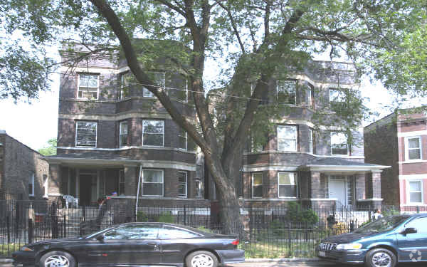
Explore a new place to live at 4240-4242 W Adams St. These apartments are located on W. Adams St. in Chicago. The community staff is ready to help you find the perfect new home. Be sure to come for a visit to see the current floorplan options. Drop by to find out the current pricing.
4240-4242 W Adams St is an apartment community located in Cook County and the 60624 ZIP Code. This area is served by the Chicago Public Schools attendance zone.
Washer/Dryer Hookup
Hardwood Floors
Walk-In Closets
Refrigerator
True to its name, West Garfield Park is located directly west of Garfield Park, a sprawling green space that features a lake, sports facilities, and the Garfield Park Conservatory. Along with the parks, this up-and-coming neighborhood is known for its affordability and locally owned restaurants. West Garfield Park has condos and apartments available for rent at every price point. Locals flock to diverse restaurants serving everything from jerk chicken tacos to Polish sausage. For shopping, head to Madison Street, a strip filled with boutiques, specialty grocery stores, chain retailers, and locally owned shops. Great for commuters, the neighborhood has access to Interstate 290 and several subway stops, making travel into Downtown Chicago easy. The heart of the city is only six miles east of West Garfield Park.
Learn more about living in West Garfield ParkCompare neighborhood and city base rent averages by bedroom.
| West Garfield Park | Chicago, IL | |
|---|---|---|
| Studio | $842 | $1,645 |
| 1 Bedroom | $991 | $2,048 |
| 2 Bedrooms | $1,132 | $2,587 |
| 3 Bedrooms | $1,370 | $3,092 |
| Colleges & Universities | Distance | ||
|---|---|---|---|
| Colleges & Universities | Distance | ||
| Drive: | 7 min | 3.9 mi | |
| Drive: | 7 min | 4.0 mi | |
| Drive: | 9 min | 5.0 mi | |
| Drive: | 12 min | 6.3 mi |


Transportation options available in Chicago include Pulaski Station (Green Line), located 0.8 mile from 4240-4242 W Adams St. 4240-4242 W Adams St is near Chicago Midway International, located 7.1 miles or 12 minutes away, and Chicago O'Hare International, located 15.9 miles or 28 minutes away.
| Transit / Subway | Distance | ||
|---|---|---|---|
| Transit / Subway | Distance | ||
|
|
Walk: | 16 min | 0.8 mi |
|
|
Drive: | 2 min | 1.1 mi |
|
|
Drive: | 3 min | 1.3 mi |
|
|
Drive: | 3 min | 1.4 mi |
|
|
Drive: | 3 min | 1.5 mi |
| Commuter Rail | Distance | ||
|---|---|---|---|
| Commuter Rail | Distance | ||
|
|
Drive: | 4 min | 2.1 mi |
|
|
Drive: | 6 min | 3.1 mi |
|
|
Drive: | 7 min | 3.3 mi |
|
|
Drive: | 8 min | 3.7 mi |
|
|
Drive: | 8 min | 4.3 mi |
| Airports | Distance | ||
|---|---|---|---|
| Airports | Distance | ||
|
Chicago Midway International
|
Drive: | 12 min | 7.1 mi |
|
Chicago O'Hare International
|
Drive: | 28 min | 15.9 mi |
Scores provided by
Traffic
-Airport
-Businesses
-Scores provided by
HowLoud What is a Sound Score Rating? A Sound Score Rating aggregates noise caused by vehicle traffic, airplane traffic and local sources. How It WorksTime and distance from 4240-4242 W Adams St.
| Shopping Centers | Distance | ||
|---|---|---|---|
| Shopping Centers | Distance | ||
| Walk: | 12 min | 0.6 mi | |
| Walk: | 16 min | 0.9 mi | |
| Drive: | 3 min | 1.5 mi |
| Parks and Recreation | Distance | ||
|---|---|---|---|
| Parks and Recreation | Distance | ||
|
Garfield Park and Golden Dome Field House
|
Drive: | 3 min | 1.1 mi |
|
Columbus Park and Field House
|
Drive: | 4 min | 1.9 mi |
|
Austin Town Hall Park
|
Drive: | 5 min | 2.5 mi |
|
LaFollette Park
|
Drive: | 6 min | 3.0 mi |
|
Douglas Park and Community Center
|
Drive: | 7 min | 3.6 mi |
| Hospitals | Distance | ||
|---|---|---|---|
| Hospitals | Distance | ||
| Drive: | 4 min | 1.6 mi | |
| Drive: | 4 min | 2.1 mi | |
| Drive: | 5 min | 2.7 mi |
| Military Bases | Distance | ||
|---|---|---|---|
| Military Bases | Distance | ||
| Drive: | 36 min | 23.6 mi | |
| Drive: | 36 min | 24.6 mi | |
| Drive: | 46 min | 29.7 mi |
What Are Walk Score®, Transit Score®, and Bike Score® Ratings?
Walk Score® measures the walkability of any address. Transit Score® measures access to public transit. Bike Score® measures the bikeability of any address.
What is a Sound Score Rating?
A Sound Score Rating aggregates noise caused by vehicle traffic, airplane traffic and local sources.
4240-4242 W Adams St
Chicago, IL 60624


