
$2,200 / Month
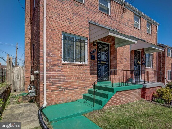
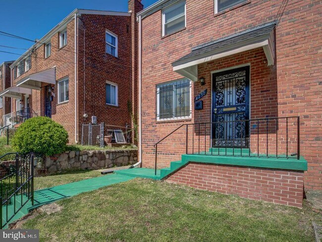
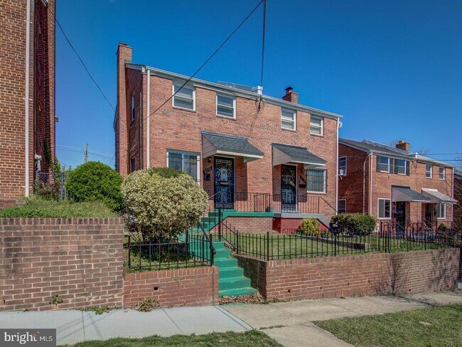
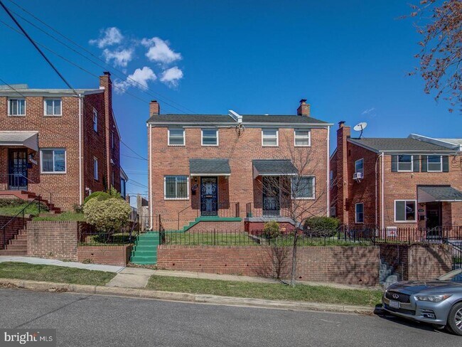
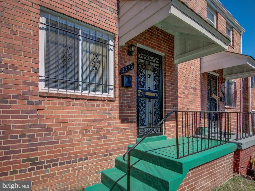
4230 Hildreth St SE
Washington, DC 20019
2 Weeks Ago
Favorites
4230 Hildreth St SE

Favorites
Check Back Soon for Upcoming Availability
| Beds | Baths | Average SF |
|---|---|---|
| 3 Bedrooms 3 Bedrooms 3 Br | 2 Baths 2 Baths 2 Ba | — |
About This Property
Welcome home to this beautiful, bright, semi-detached home in the quiet Fort Dupont Park neighborhood! The property boasts around 1,250 sq ft spread over 3 levels with 3 bedrooms and 2 bathrooms. This property has a large fenced in yard with a private covered porch. Upon entering through the front door you instantly notice beautiful hardwood floors, and the open concept design with beautiful flow. The kitchen has been upgraded and modernized with a large Island with a sink. The second level has 2 large bedrooms and an updated bathroom.The basement has a large rec room with a full upgraded bathroom,bedroom and washer /dryer. Pets are welcome, some restrictions apply. None of the utilities are included in the rent so we will have to include a credit check. This property is located very close to Capitol Hill, 295, 395, 695 and easy access to 495.
4230 Hildreth St SE is a townhome located in District of Columbia County and the 20019 ZIP Code. This area is served by the District Of Columbia Public Schools attendance zone.
Townhome Features
- Basement
Location
Get Directions
The residential neighborhood of Fort Dupont sits just east of the Anacostia River in Southeast Washington, DC. The neighborhood has ample green space provided by two adjacent parks — Fort Circle Park and Fort Chaplin Park — and distinguishes itself within the Greater Anacostia area by housing the only public indoor ice rink in Washington, DC.
There’s a diverse mix of rentals in Fort Dupont, from more recent and upscale developments to long-standing apartment homes closer to the Anacostia River. Proximity to the Benning Road Metro Station makes Fort Dupont perfect for the Capitol Hill commuter who wishes to reside outside the bustle of DC.
Learn more about living in Fort DupontBelow are rent ranges for similar nearby apartments
Amenities
- Basement
Education
| Colleges & Universities | Distance | ||
|---|---|---|---|
| Colleges & Universities | Distance | ||
| Drive: | 9 min | 4.4 mi | |
| Drive: | 10 min | 5.4 mi | |
| Drive: | 10 min | 5.4 mi | |
| Drive: | 10 min | 5.8 mi |
4230 Hildreth St SE is within 9 minutes or 4.4 miles from Gallaudet University. It is also near Georgetown and Georgetown Law.
Schools


Public Elementary School
Grades PK-5
203 Students
Attendance Zone
Public Middle School
Grades 6-8
215 Students
Attendance Zone
Public High School
Grades 9-12
287 Students
Attendance Zone
Private Elementary, Middle & High School
Grades PK-12
149 Students
Nearby
School data provided by
 The GreatSchools Rating helps parents compare schools within a state based on a variety of school quality indicators and provides a helpful picture of how effectively each school serves all of its students. Ratings are on a scale of 1 (below average) to 10 (above average) and can include test scores, college readiness, academic progress, advanced courses, equity, discipline and attendance data. We also advise parents to visit schools, consider other information on school performance and programs, and consider family needs as part of the school selection process.
View GreatSchools Rating Methodology
Data provided by GreatSchools.org © 2025. All rights reserved.
View GreatSchools Rating Methodology
Data provided by GreatSchools.org © 2025. All rights reserved.
Transportation options available in Washington include Benning Road, located 1.1 miles from 4230 Hildreth St SE. 4230 Hildreth St SE is near Ronald Reagan Washington Ntl, located 9.6 miles or 18 minutes away, and Baltimore/Washington International Thurgood Marshall, located 29.4 miles or 44 minutes away.
| Transit / Subway | Distance | ||
|---|---|---|---|
| Transit / Subway | Distance | ||
|
|
Drive: | 3 min | 1.1 mi |
|
|
Drive: | 5 min | 2.1 mi |
|
Capitol Heights, Blue/Silver Line Center Platform
|
Drive: | 6 min | 2.2 mi |
| Drive: | 5 min | 2.7 mi | |
|
|
Drive: | 6 min | 3.1 mi |
| Commuter Rail | Distance | ||
|---|---|---|---|
| Commuter Rail | Distance | ||
|
|
Drive: | 8 min | 4.7 mi |
|
|
Drive: | 9 min | 4.8 mi |
|
|
Drive: | 11 min | 5.5 mi |
|
|
Drive: | 11 min | 5.5 mi |
|
|
Drive: | 15 min | 8.2 mi |
| Airports | Distance | ||
|---|---|---|---|
| Airports | Distance | ||
|
Ronald Reagan Washington Ntl
|
Drive: | 18 min | 9.6 mi |
|
Baltimore/Washington International Thurgood Marshall
|
Drive: | 44 min | 29.4 mi |
Time and distance from 4230 Hildreth St SE.
| Shopping Centers | Distance | ||
|---|---|---|---|
| Shopping Centers | Distance | ||
| Walk: | 17 min | 0.9 mi | |
| Drive: | 3 min | 1.1 mi | |
| Drive: | 3 min | 1.2 mi |
4230 Hildreth St SE has 3 shopping centers within 1.2 miles, which is about a 3-minute walk. The miles and minutes will be for the farthest away property.
| Parks and Recreation | Distance | ||
|---|---|---|---|
| Parks and Recreation | Distance | ||
|
Fort Dupont Park
|
Walk: | 12 min | 0.7 mi |
|
Kingman and Heritage Island Park
|
Drive: | 5 min | 2.6 mi |
|
Frederick Douglass National Historic Site
|
Drive: | 9 min | 3.7 mi |
|
Kenilworth Park & Aquatic Gardens
|
Drive: | 9 min | 4.0 mi |
|
National Arboretum
|
Drive: | 11 min | 4.9 mi |
4230 Hildreth St SE has 5 parks within 4.9 miles, including Fort Dupont Park, Kingman and Heritage Island Park, and Frederick Douglass National Historic Site.
| Hospitals | Distance | ||
|---|---|---|---|
| Hospitals | Distance | ||
| Drive: | 12 min | 4.5 mi | |
| Drive: | 12 min | 5.0 mi | |
| Drive: | 12 min | 5.8 mi |
4230 Hildreth St SE has 3 hospitals within 5.8 miles, the nearest is St. Elizabeth's Hospital which is 4.5 miles away and a 12 minute drive.
| Military Bases | Distance | ||
|---|---|---|---|
| Military Bases | Distance | ||
| Drive: | 9 min | 4.4 mi | |
| Drive: | 12 min | 5.2 mi |
4230 Hildreth St SE is 4.4 miles from Washington Navy Yard, and is convenient to other military bases, including Anacostia Naval Station.
You May Also Like
Similar Rentals Nearby


What Are Walk Score®, Transit Score®, and Bike Score® Ratings?
Walk Score® measures the walkability of any address. Transit Score® measures access to public transit. Bike Score® measures the bikeability of any address.
What is a Sound Score Rating?
A Sound Score Rating aggregates noise caused by vehicle traffic, airplane traffic and local sources
4230 Hildreth St SE
Washington, DC 20019