
$2,500
/ Month
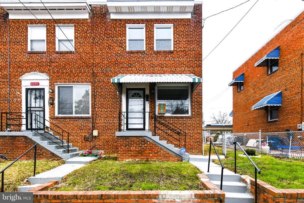
4227 Nash St SE
Washington, DC 20020
1 Day Ago
|
Edit
Favorites
301-841-5533
-
Bedrooms
2
-
Bathrooms
2
-
Square Feet
864 sq ft
-
Available
Available Now
Highlights
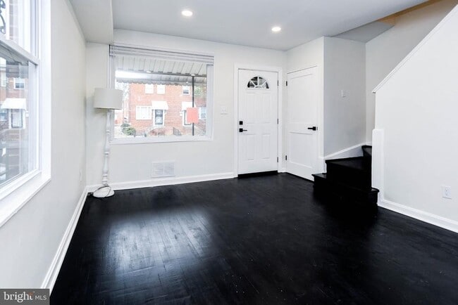
- Open Floorplan
- 90% Forced Air Heating and Cooling System
4227 Nash St SE

Favorites
About This Home
Available Now
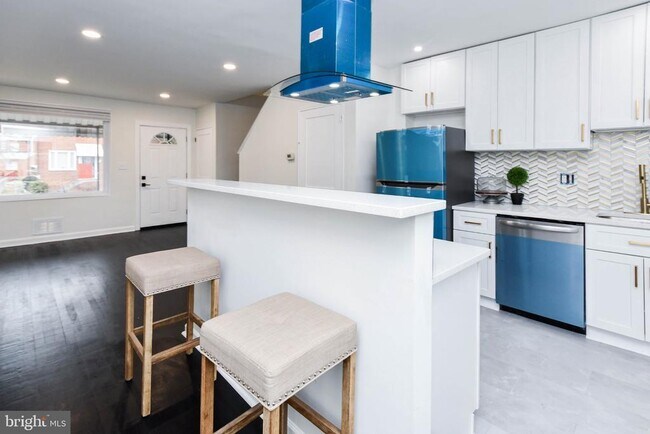
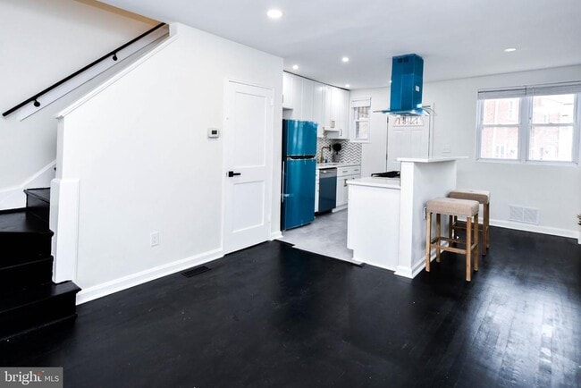
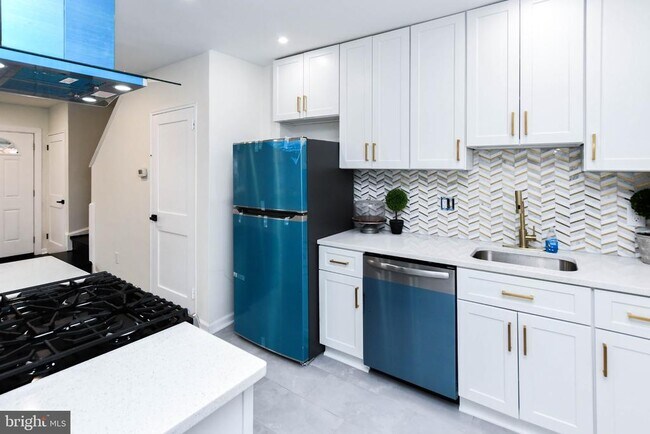
Welcome to this fully updated home featuring a bright open floor plan, modern kitchen with stainless steel appliances, sleek cabinetry, and contemporary finishes throughout. The finished basement provides extra living space—perfect for a home office, gym, or guest area. Enjoy the fenced, low-maintenance yard ideal for relaxing or entertaining. Conveniently located near shopping, dining, and public transportation with easy access to major commuter routes. Don’t miss this beautifully updated home—schedule your private tour today!
4227 Nash St SE is a house located in District of Columbia County and the 20020 ZIP Code. This area is served by the District Of Columbia Public Schools attendance zone.
* Price shown is base rent. Excludes user-selected optional fees and variable or usage-based fees and required charges due at or prior to move-in or at move-out. Price, availability, fees, and any applicable rent special are subject to change without notice.
* Square footage definitions vary. Displayed square footage is approximate.
Home Details
Home Type
Semi-Detached or Twin Home
Year Built
Built in 1953
Bedrooms and Bathrooms
2 Full Bathrooms
2 Bedrooms
Finished Basement
Connecting Stairway
Home Design
Brick Exterior Construction
Brick Foundation
Interior Spaces
Open Floorplan
864 Sq Ft Home
Property has 3 Levels
Laundry
Washer and Dryer Hookup
Listing and Financial Details
Security Deposit $2,500
12-Month Lease Term
Available 10/23/25
Assessor Parcel Number 5373/S/0015
Tenant pays for electricity, gas, insurance, internet, lawn/tree/shrub care, all utilities, water
No Smoking Allowed
Residential Lease
Lot Details
1,975 Sq Ft Lot
Parking
On-Street Parking
Utilities
90% Forced Air Heating and Cooling System
Natural Gas Water Heater
Community Details
Overview
No Home Owners Association
Fort Dupont Park Subdivision
Pet Policy
Pets allowed on a case-by-case basis
Contact
- Listed by Shana M Osborne | Keller Williams Preferred Properties
- Phone Number
- Contact
-
Source
 Bright MLS, Inc.
Copyright © 2026 Bright MLS, Inc.
Location
Get Directions
Amenities
- Basement
The residential neighborhood of Fort Dupont sits just east of the Anacostia River in Southeast Washington, DC. The neighborhood has ample green space provided by two adjacent parks — Fort Circle Park and Fort Chaplin Park — and distinguishes itself within the Greater Anacostia area by housing the only public indoor ice rink in Washington, DC.
There’s a diverse mix of rentals in Fort Dupont, from more recent and upscale developments to long-standing apartment homes closer to the Anacostia River. Proximity to the Benning Road Metro Station makes Fort Dupont perfect for the Capitol Hill commuter who wishes to reside outside the bustle of DC.
Learn more about living in Fort Dupont
Education
| Colleges & Universities | Distance | ||
|---|---|---|---|
| Colleges & Universities | Distance | ||
| Drive: | 11 min | 5.2 mi | |
| Drive: | 11 min | 5.4 mi | |
| Drive: | 11 min | 5.4 mi | |
| Drive: | 12 min | 6.6 mi |
4227 Nash St SE is within 11 minutes or 5.4 miles from Georgetown. It is also near Georgetown Law and Gallaudet University.
Schools


Public Elementary School
Grades PK-5
372 Students
Attendance Zone
Public Middle School
Grades 6-8
215 Students
Attendance Zone
Public High School
Grades 9-12
287 Students
Attendance Zone
Private Elementary, Middle & High School
Grades PK-12
149 Students
Nearby
Private Elementary & Middle School
Grades PK-8
130 Students
Nearby
School data provided by
 The GreatSchools Rating helps parents compare schools within a state based on a variety of school quality indicators and provides a helpful picture of how effectively each school serves all of its students. Ratings are on a scale of 1 (below average) to 10 (above average) and can include test scores, college readiness, academic progress, advanced courses, equity, discipline and attendance data. We also advise parents to visit schools, consider other information on school performance and programs, and consider family needs as part of the school selection process.
View GreatSchools Rating Methodology
Data provided by GreatSchools.org © 2026. All rights reserved.
View GreatSchools Rating Methodology
Data provided by GreatSchools.org © 2026. All rights reserved.
Transportation options available in Washington include Naylor Road, located 1.8 miles from 4227 Nash St SE. 4227 Nash St SE is near Ronald Reagan Washington Ntl, located 9.1 miles or 17 minutes away, and Baltimore/Washington International Thurgood Marshall, located 30.2 miles or 46 minutes away.
| Transit / Subway | Distance | ||
|---|---|---|---|
| Transit / Subway | Distance | ||
|
|
Drive: | 4 min | 1.8 mi |
|
|
Drive: | 5 min | 2.0 mi |
|
Capitol Heights, Blue/Silver Line Center Platform
|
Drive: | 6 min | 2.4 mi |
|
|
Drive: | 6 min | 2.9 mi |
|
|
Drive: | 9 min | 3.2 mi |
| Commuter Rail | Distance | ||
|---|---|---|---|
| Commuter Rail | Distance | ||
|
|
Drive: | 10 min | 5.0 mi |
|
|
Drive: | 10 min | 5.0 mi |
|
|
Drive: | 10 min | 5.5 mi |
|
|
Drive: | 11 min | 5.6 mi |
|
|
Drive: | 14 min | 7.7 mi |
| Airports | Distance | ||
|---|---|---|---|
| Airports | Distance | ||
|
Ronald Reagan Washington Ntl
|
Drive: | 17 min | 9.1 mi |
|
Baltimore/Washington International Thurgood Marshall
|
Drive: | 46 min | 30.2 mi |
Time and distance from 4227 Nash St SE.
| Shopping Centers | Distance | ||
|---|---|---|---|
| Shopping Centers | Distance | ||
| Walk: | 12 min | 0.6 mi | |
| Walk: | 15 min | 0.8 mi | |
| Walk: | 15 min | 0.8 mi |
4227 Nash St SE has 3 shopping centers within 0.8 mile, which is about a 15-minute walk. The miles and minutes will be for the farthest away property.
| Parks and Recreation | Distance | ||
|---|---|---|---|
| Parks and Recreation | Distance | ||
|
Fort Dupont Park
|
Walk: | 21 min | 1.1 mi |
|
Oxon Cove Park
|
Drive: | 8 min | 3.1 mi |
|
Frederick Douglass National Historic Site
|
Drive: | 8 min | 3.2 mi |
|
Kingman and Heritage Island Park
|
Drive: | 6 min | 3.4 mi |
|
Kenilworth Park & Aquatic Gardens
|
Drive: | 8 min | 3.5 mi |
4227 Nash St SE has 5 parks within 3.5 miles, including Fort Dupont Park, Oxon Cove Park, and Frederick Douglass National Historic Site.
| Hospitals | Distance | ||
|---|---|---|---|
| Hospitals | Distance | ||
| Drive: | 10 min | 3.7 mi | |
| Drive: | 9 min | 3.8 mi | |
| Drive: | 11 min | 5.4 mi |
4227 Nash St SE has 3 hospitals within 5.4 miles, the nearest is St. Elizabeth's Hospital which is 3.7 miles away and a 10 minute drive.
| Military Bases | Distance | ||
|---|---|---|---|
| Military Bases | Distance | ||
| Drive: | 8 min | 3.9 mi | |
| Drive: | 11 min | 4.7 mi |
4227 Nash St SE is 3.9 miles from Washington Navy Yard, and is convenient to other military bases, including Anacostia Naval Station.
You May Also Like
Similar Rentals Nearby


What Are Walk Score®, Transit Score®, and Bike Score® Ratings?
Walk Score® measures the walkability of any address. Transit Score® measures access to public transit. Bike Score® measures the bikeability of any address.
What is a Sound Score Rating?
A Sound Score Rating aggregates noise caused by vehicle traffic, airplane traffic and local sources

4227 Nash St SE
Washington, DC 20020