

$2,250
/ Month
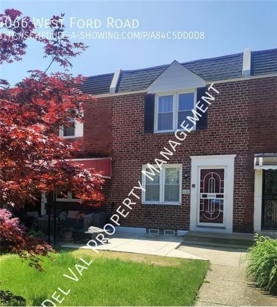
4066 W Ford Rd
Philadelphia, PA 19131
Favorites
4066 W Ford Rd

Favorites
Check Back Soon for Upcoming Availability
| Beds | Baths | Average SF |
|---|---|---|
| 3 Bedrooms 3 Bedrooms 3 Br | 2 Baths 2 Baths 2 Ba | 1,120 SF |
About This Property
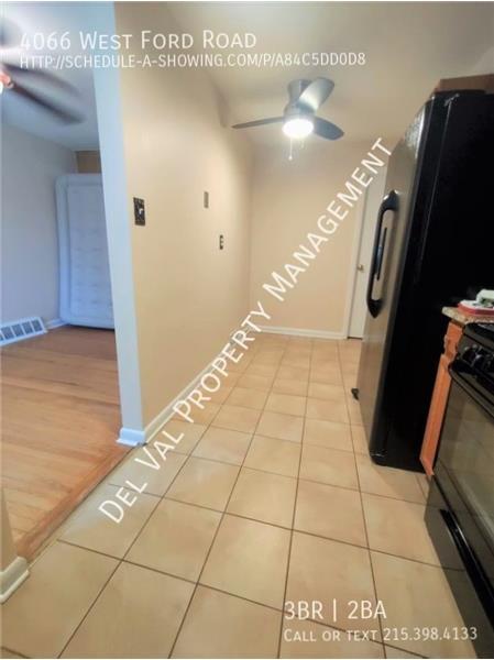
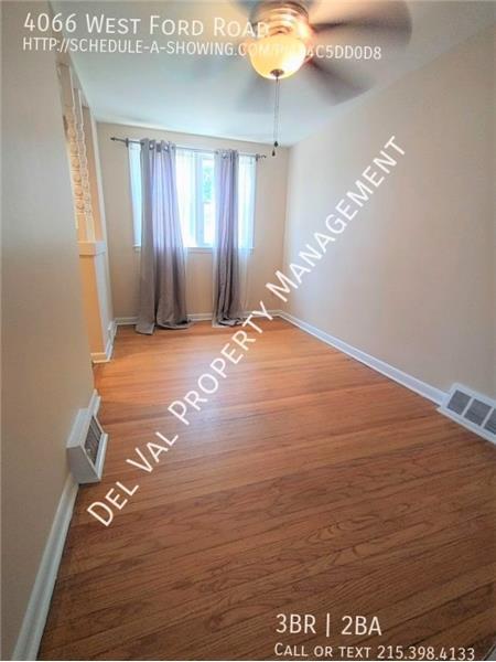
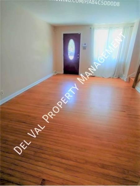
Beautifully Renovated Townhouse for Rent 4066 West Ford Rd, Philadelphia Wynnefield Heights $2,250/month plus utilities (landscaping & snow removal included in rent) 3 Bedrooms 1.5 Bathrooms 1,120 sq ft. Security system Central Air Modern eat-in kitchen boasts oak cabinets & new appliances, plus More! Finished Basement comes with Washer/Dryer 1-car Garage in back, driveway & street parking For more information or a Showing, please see Description Page!
4066 W Ford Rd is a townhome located in Philadelphia County and the 19131 ZIP Code. This area is served by the The School District of Philadelphia attendance zone.
4066 W Ford Rd,
Philadelphia,
PA
19131
Located in the outer stretches of West Philadelphia, about six miles northwest of Center City, Wynnefield Heights offers residents a laidback atmosphere. Dense with tree-lined streets and lush green spaces, the neighborhood is teeming with recreational opportunities. Wynnefield Heights is also convenient to the sprawling West Fairmount Park, where outdoor delights abound.
Historic brick buildings and a diverse population contribute to the unique character of Wynnefield Heights as well. The Philadelphia College of Osteopathic Medicine is situated in the neighborhood, making Wynnefield Heights a top choice for many students, faculty, and staff.
Convenience to the Bala Cynwyd Shopping Center provides residents with plenty of shopping opportunities nearby, while the SEPTA Cynwyd Line and I-76 connects the neighborhood to the rest of the Greater Philadelphia Area.
Learn more about living in Wynnefield HeightsBelow are rent ranges for similar nearby apartments
Education
| Colleges & Universities | Distance | ||
|---|---|---|---|
| Colleges & Universities | Distance | ||
| Walk: | 12 min | 0.6 mi | |
| Drive: | 6 min | 2.0 mi | |
| Drive: | 8 min | 2.9 mi | |
| Drive: | 8 min | 3.2 mi |
4066 W Ford Rd is within 12 minutes or 0.6 mile from Philadelphia Osteopathic. It is also near St Joseph's Univ., Phila. and Philadelphia University.
Schools


Public Elementary School
Grades K-5
532 Students
Nearby
Public Elementary & Middle School
Grades PK-8
363 Students
Nearby
Public High School
Grades 9-12
387 Students
Attendance Zone
Private Elementary, Middle & High School
Grades PK-12
60 Students
Nearby
School data provided by
 The GreatSchools Rating helps parents compare schools within a state based on a variety of school quality indicators and provides a helpful picture of how effectively each school serves all of its students. Ratings are on a scale of 1 (below average) to 10 (above average) and can include test scores, college readiness, academic progress, advanced courses, equity, discipline and attendance data. We also advise parents to visit schools, consider other information on school performance and programs, and consider family needs as part of the school selection process.
View GreatSchools Rating Methodology
Data provided by GreatSchools.org © 2026. All rights reserved.
View GreatSchools Rating Methodology
Data provided by GreatSchools.org © 2026. All rights reserved.
Transportation options available in Philadelphia include Lancaster Avenue And 52Nd Street, located 2.2 miles from 4066 W Ford Rd. 4066 W Ford Rd is near Philadelphia International, located 13.7 miles or 26 minutes away, and Trenton Mercer, located 33.0 miles or 57 minutes away.
| Transit / Subway | Distance | ||
|---|---|---|---|
| Transit / Subway | Distance | ||
|
|
Drive: | 5 min | 2.2 mi |
| Drive: | 6 min | 2.4 mi | |
|
|
Drive: | 6 min | 2.4 mi |
|
|
Drive: | 6 min | 2.5 mi |
| Drive: | 6 min | 2.5 mi |
| Commuter Rail | Distance | ||
|---|---|---|---|
| Commuter Rail | Distance | ||
|
|
Drive: | 3 min | 1.1 mi |
|
|
Drive: | 4 min | 1.4 mi |
|
|
Drive: | 4 min | 1.5 mi |
|
|
Drive: | 6 min | 2.0 mi |
|
|
Drive: | 6 min | 2.4 mi |
| Airports | Distance | ||
|---|---|---|---|
| Airports | Distance | ||
|
Philadelphia International
|
Drive: | 26 min | 13.7 mi |
|
Trenton Mercer
|
Drive: | 57 min | 33.0 mi |
Walkability Near 4066 W Ford Rd Philadelphia, PA 19131
Getting Around
 What do Walkability, Transit, Drivability, and Bikeability mean?
Walkability measures the walking distance to day-to-day needs.
Transit measures access to public transportation.
Drivability measures congestion, parking availability, and access to major roads.
Bikeability measures the suitability for cycling.
How It Works
What do Walkability, Transit, Drivability, and Bikeability mean?
Walkability measures the walking distance to day-to-day needs.
Transit measures access to public transportation.
Drivability measures congestion, parking availability, and access to major roads.
Bikeability measures the suitability for cycling.
How It Works
Moderately Walkable
Walkability
70
/ 100
Good Public Transit
Transit
60
/ 100
Exceptionally Drivable
Drivability
100
/ 100
Exceptionally Bikeable
Bikeability
90
/ 100
Scores provided by
-
Soundscore™
-
/ 100
Traffic
-Airport
-Businesses
-Scores provided by
HowLoud What is a Sound Score Rating? A Sound Score Rating aggregates noise caused by vehicle traffic, airplane traffic and local sources. How It WorksTime and distance from 4066 W Ford Rd.
| Shopping Centers | Distance | ||
|---|---|---|---|
| Shopping Centers | Distance | ||
| Walk: | 4 min | 0.2 mi | |
| Walk: | 7 min | 0.4 mi | |
| Walk: | 11 min | 0.6 mi |
4066 W Ford Rd has 3 shopping centers within 0.6 mile, which is about a 11-minute walk. The miles and minutes will be for the farthest away property.
| Parks and Recreation | Distance | ||
|---|---|---|---|
| Parks and Recreation | Distance | ||
|
Fairmount Park
|
Drive: | 6 min | 1.8 mi |
|
Please Touch Museum
|
Drive: | 5 min | 2.0 mi |
|
Shofuso - Japanese House and Garden
|
Drive: | 6 min | 2.0 mi |
|
Arboretum of the Barnes Foundation
|
Drive: | 5 min | 2.0 mi |
|
Merion Botanical Park
|
Drive: | 7 min | 2.6 mi |
4066 W Ford Rd has 5 parks within 2.6 miles, including Shofuso - Japanese House and Garden, Fairmount Park, and Please Touch Museum.
| Hospitals | Distance | ||
|---|---|---|---|
| Hospitals | Distance | ||
| Drive: | 8 min | 2.7 mi | |
| Drive: | 10 min | 3.8 mi | |
| Drive: | 11 min | 4.4 mi |
4066 W Ford Rd has 3 hospitals within 4.4 miles, the nearest is Roxborough Memorial Hospital which is 2.7 miles away and a 8 minute drive.
| Military Bases | Distance | ||
|---|---|---|---|
| Military Bases | Distance | ||
| Drive: | 19 min | 10.5 mi | |
| Drive: | 41 min | 21.8 mi | |
| Drive: | 39 min | 26.2 mi |
4066 W Ford Rd has 3 military bases within 26.2 miles, the nearest is Philadelphia Naval Busi Center which is 10.5 miles away and a 19 minute drive.
You May Also Like
Similar Rentals Nearby


What Are Walk Score®, Transit Score®, and Bike Score® Ratings?
Walk Score® measures the walkability of any address. Transit Score® measures access to public transit. Bike Score® measures the bikeability of any address.
What is a Sound Score Rating?
A Sound Score Rating aggregates noise caused by vehicle traffic, airplane traffic and local sources.
4066 W Ford Rd
Philadelphia, PA 19131