
$2,150
/ Month
404 Cedarleaf Ave
Capitol Heights, MD 20743
Today
Favorites
240-712-4742
-
Bedrooms
3
-
Bathrooms
1
-
Square Feet
--
-
Available
Available Now
Highlights
- Open Floorplan
- Rambler Architecture
- Main Floor Bedroom
- Upgraded Countertops
- Breakfast Area or Nook
- Stainless Steel Appliances
404 Cedarleaf Ave

Favorites
About This Home
Available Now
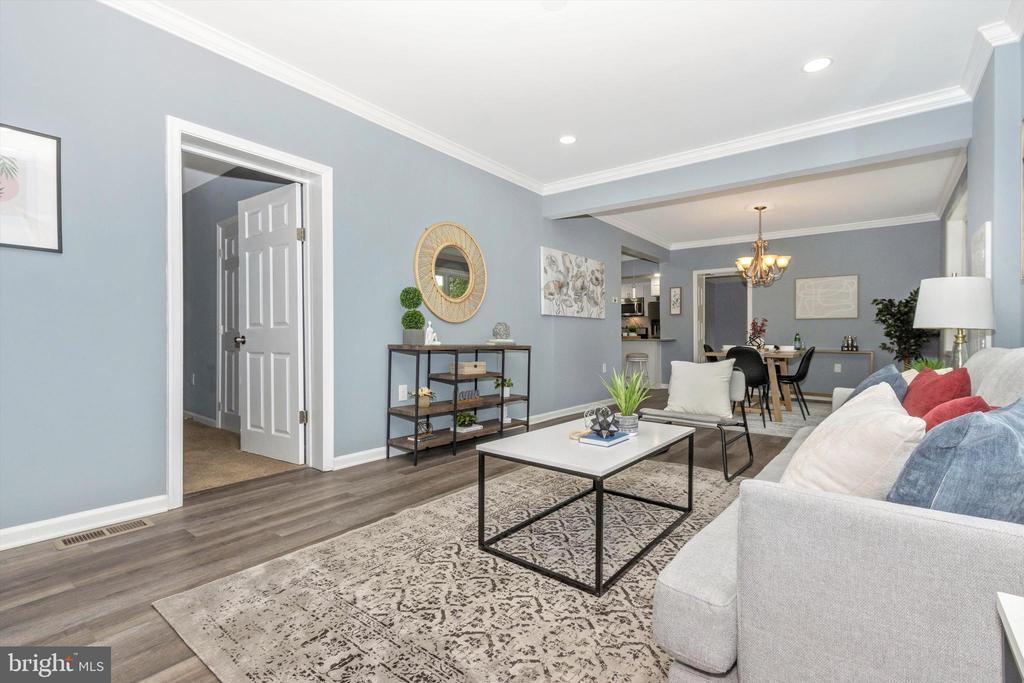
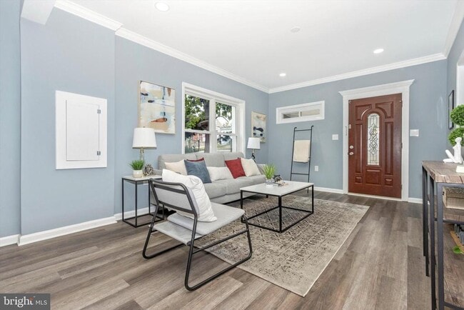
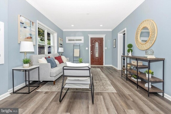
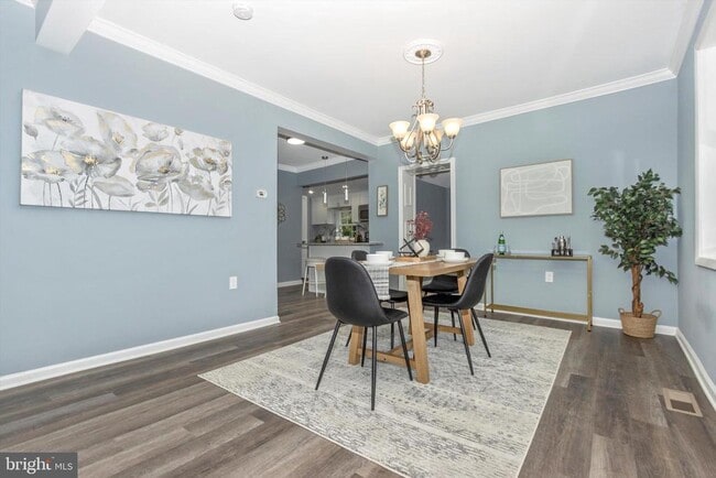
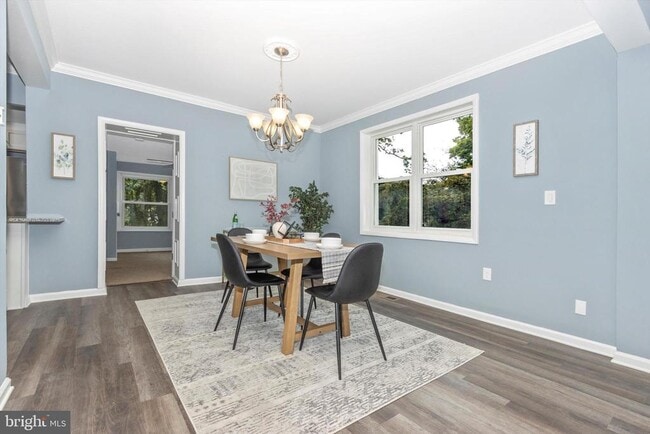
You're going to want to see this gorgeous 3-Bedroom, 1 bathroom apartment home in Capitol Heights! This newly renovated first-floor unit provides a perfect blend of space and style. Say goodbye to the hassle of managing multiple bills because the rent includes **all utilities**! The basement unit is occupied by the owner. Nestled in the heart of Capitol Heights, this property offers proximity to local amenities, schools, and public transport. Explore the community and discover the convenience of city living. Prospective tenants to have a credit score of 615+ and a minimum gross monthly income of $6000. Fill out the easy online application today!
404 Cedarleaf Ave is a house located in Prince George's County and the 20743 ZIP Code. This area is served by the Prince George's County Public Schools attendance zone.
* Price shown is base rent. Excludes user-selected optional fees and variable or usage-based fees and required charges due at or prior to move-in or at move-out. Price, availability, fees, and any applicable rent special are subject to change without notice.
* Square footage definitions vary. Displayed square footage is approximate.
Home Details
Home Type
Single Family Detached Home
Year Built
Built in 1961 | Remodeled in 2023
Bedrooms and Bathrooms
3 Main Level Bedrooms
1 Full Bathroom
Dual Flush Toilets
Home Design
Rambler Architecture
Shingle Roof
Concrete Perimeter Foundation
Frame Construction
Entry on the 1st floor
Home Security
Home Security System
Interior Spaces
Open Floorplan
Ceiling Fan
Dining Area
Laminate Flooring
1,427 Sq Ft Home
Property has 2 Levels
Kitchen
Upgraded Countertops
Breakfast Area or Nook
Stainless Steel Appliances
Eat-In Kitchen
Gas Oven or Range
Built-In Microwave
Dishwasher
Disposal
Laundry
Dryer
Laundry on main level
Washer
Listing and Financial Details
Security Deposit $2,150
12-Month Min and 24-Month Max Lease Term
Available 10/1/25
Assessor Parcel Number 17182078442
Coming Soon on 9/24/25
Residential Lease
Lot Details
8,000 Sq Ft Lot
Property is in excellent condition
Property is Fully Fenced
Wood Fence
Property is zoned RSF65
Outdoor Features
Porch
Shed
Exterior Lighting
Parking
On-Street Parking
Off-Street Parking
Driveway
Schools
Central High School
Utilities
Central Air
Heat Pump System
Electric Water Heater
Vented Exhaust Fan
Community Details
Overview
No Home Owners Association
Carmody Hills Subdivision
Pet Policy
No Pets Allowed
Contact
- Listed by Aisha Holmes | Samson Properties
- Phone Number
- Contact
-
Source
 Bright MLS, Inc.
Copyright © 2025 Bright MLS, Inc.
Location
Get Directions
Amenities
- Dishwasher
- Basement
Capitol Heights -- named for its location near Washington, DC -- provides the perfect location: near DC, near the Capital Beltway, and minutes away from FedEx Field, home of the NFL's Washington Football Team. It is also close to the Anacostia River, the United States National Arboretum, and Joint Base Anacostia-Bolling. Nearby Fort Circle Park provides Capitol Heights residents with 10 miles of hiking trails -- it is also a popular concert venue and is home to Fort Dupont Ice Rink.
Capitol Heights is a terrific location for your DC-area apartment, only about seven miles southeast of downtown. Hop on the Metro at the Capitol Heights Metro Station for a fast, car-free commute. Despite being so close to the historic sites of DC, Capitol Heights was a rural area with no paved roads or streetlights. In 1910, the 200 residents in the area named their town "Capitol Heights," but it wasn't until 1980 and the arrival of the Metro Blue Line that the town began to grow.
Learn more about living in Capitol Heights
Education
| Colleges & Universities | Distance | ||
|---|---|---|---|
| Colleges & Universities | Distance | ||
| Drive: | 10 min | 4.7 mi | |
| Drive: | 11 min | 5.1 mi | |
| Drive: | 13 min | 6.4 mi | |
| Drive: | 15 min | 8.0 mi |
404 Cedarleaf Ave is within 10 minutes or 4.7 miles from Univ. of Md. Univ. Coll.. It is also near Prince George's Comm. Coll. and Gallaudet University.
Schools


Public Elementary School
Grades PK-5
443 Students
Attendance Zone
Public Middle School
Grades 6-8
867 Students
Attendance Zone
Public High School
Grades 9-12
877 Students
Attendance Zone
Private Elementary & Middle School
Grades PK-8
Nearby
Private High School
Grades 9-12
Nearby
School data provided by
 The GreatSchools Rating helps parents compare schools within a state based on a variety of school quality indicators and provides a helpful picture of how effectively each school serves all of its students. Ratings are on a scale of 1 (below average) to 10 (above average) and can include test scores, college readiness, academic progress, advanced courses, equity, discipline and attendance data. We also advise parents to visit schools, consider other information on school performance and programs, and consider family needs as part of the school selection process.
View GreatSchools Rating Methodology
Data provided by GreatSchools.org © 2025. All rights reserved.
View GreatSchools Rating Methodology
Data provided by GreatSchools.org © 2025. All rights reserved.
Transportation options available in Capitol Heights include Capitol Heights, Blue/Silver Line Center Platform, located 1.7 miles from 404 Cedarleaf Ave. 404 Cedarleaf Ave is near Ronald Reagan Washington Ntl, located 12.9 miles or 24 minutes away, and Baltimore/Washington International Thurgood Marshall, located 29.2 miles or 44 minutes away.
| Transit / Subway | Distance | ||
|---|---|---|---|
| Transit / Subway | Distance | ||
|
Capitol Heights, Blue/Silver Line Center Platform
|
Drive: | 4 min | 1.7 mi |
|
|
Drive: | 4 min | 1.8 mi |
|
|
Drive: | 8 min | 2.6 mi |
|
|
Drive: | 6 min | 2.7 mi |
|
|
Drive: | 8 min | 3.1 mi |
| Commuter Rail | Distance | ||
|---|---|---|---|
| Commuter Rail | Distance | ||
|
|
Drive: | 12 min | 6.6 mi |
|
|
Drive: | 14 min | 7.0 mi |
| Drive: | 14 min | 7.3 mi | |
|
|
Drive: | 14 min | 7.3 mi |
| Drive: | 18 min | 8.1 mi |
| Airports | Distance | ||
|---|---|---|---|
| Airports | Distance | ||
|
Ronald Reagan Washington Ntl
|
Drive: | 24 min | 12.9 mi |
|
Baltimore/Washington International Thurgood Marshall
|
Drive: | 44 min | 29.2 mi |
Time and distance from 404 Cedarleaf Ave.
| Shopping Centers | Distance | ||
|---|---|---|---|
| Shopping Centers | Distance | ||
| Walk: | 15 min | 0.8 mi | |
| Drive: | 4 min | 1.6 mi | |
| Drive: | 4 min | 1.8 mi |
404 Cedarleaf Ave has 3 shopping centers within 1.8 miles, which is about a 4-minute walk. The miles and minutes will be for the farthest away property.
| Parks and Recreation | Distance | ||
|---|---|---|---|
| Parks and Recreation | Distance | ||
|
Walker Mill Regional Park
|
Drive: | 8 min | 3.2 mi |
|
Fort Dupont Park
|
Drive: | 10 min | 4.0 mi |
|
Kingman and Heritage Island Park
|
Drive: | 9 min | 4.6 mi |
|
Bladensburg Waterfront Park
|
Drive: | 9 min | 5.1 mi |
|
National Arboretum
|
Drive: | 13 min | 6.5 mi |
404 Cedarleaf Ave has 5 parks within 6.5 miles, including Walker Mill Regional Park, Fort Dupont Park, and Kingman and Heritage Island Park.
| Hospitals | Distance | ||
|---|---|---|---|
| Hospitals | Distance | ||
| Drive: | 9 min | 4.3 mi | |
| Drive: | 17 min | 7.1 mi | |
| Drive: | 17 min | 7.3 mi |
404 Cedarleaf Ave has 3 hospitals within 7.3 miles, the nearest is University of Maryland Prince George's Hospital Center which is 4.3 miles away and a 9 minute drive.
| Military Bases | Distance | ||
|---|---|---|---|
| Military Bases | Distance | ||
| Drive: | 15 min | 6.9 mi | |
| Drive: | 18 min | 8.4 mi |
404 Cedarleaf Ave is 6.9 miles from Washington Navy Yard, and is convenient to other military bases, including Andrews Airforce Base.
You May Also Like
Similar Rentals Nearby


What Are Walk Score®, Transit Score®, and Bike Score® Ratings?
Walk Score® measures the walkability of any address. Transit Score® measures access to public transit. Bike Score® measures the bikeability of any address.
What is a Sound Score Rating?
A Sound Score Rating aggregates noise caused by vehicle traffic, airplane traffic and local sources

404 Cedarleaf Ave
Capitol Heights, MD 20743