
$2,800
/ Month
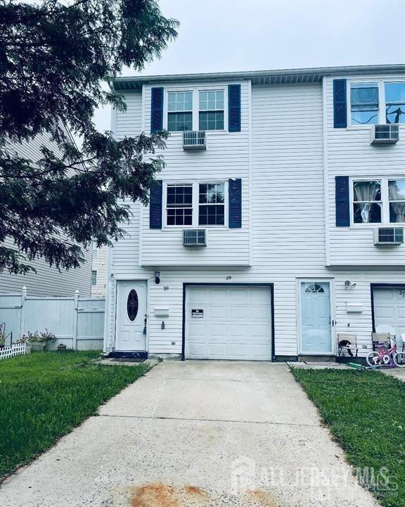
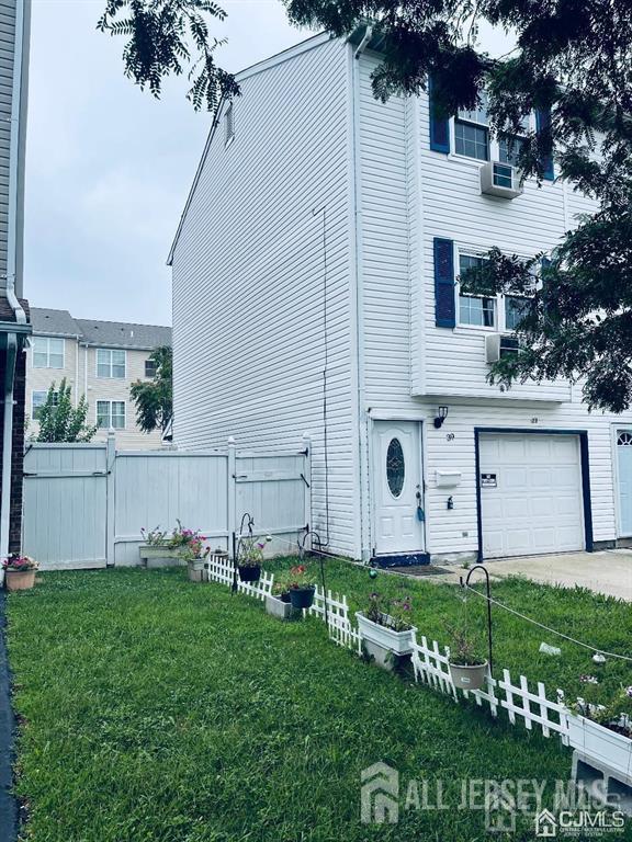
39 Larch St
Carteret, NJ 07008
1 Day Ago
|
Edit
Favorites
732-321-1001
-
Bedrooms
2
-
Bathrooms
1.5
-
Square Feet
1,603 sq ft
-
Available
Available Now
Highlights
- Colonial Architecture
- Wood Flooring
- Corner Lot
- 1 Car Attached Garage
- Eat-In Kitchen
- Laundry Room
39 Larch St

Favorites
About This Home
12 Month Lease
,
Available Now
Nice updated 3 bedroom with attached garage,Newer kitchen and bathrooms,freshly painted,Hardwood flooring.
39 Larch St is a condo located in Middlesex County and the 07008 ZIP Code.
* Price shown is base rent. Excludes user-selected optional fees and variable or usage-based fees and required charges due at or prior to move-in or at move-out. Price, availability, fees, and any applicable rent special are subject to change without notice.
* Square footage definitions vary. Displayed square footage is approximate.
Home Details
Home Type
Condominium
Year Built
Built in 1989
Bedrooms and Bathrooms
Bathtub and Shower Combination in Primary Bathroom
1.5 Bathrooms
2 Bedrooms
Flooring
Wood
Ceramic Tile
Home Design
Colonial Architecture
Interior Spaces
Entrance Foyer
Combination Dining and Living Room
1,603 Sq Ft Home
3-Story Property
Kitchen
Eat-In Kitchen
Gas Oven or Range
Dishwasher
Laundry
Laundry Room
Washer and Dryer
Listing and Financial Details
12 Month Lease Term
Tenant pays for repairs, all utilities, electricity, gas, snow removal, trash collection, interior repairs, water
Location
Property is near shops
Lot Details
1,999 Sq Ft Lot
Corner Lot
Garden
Lot Dimensions are 100.00 x 25.00
Parking
1 Car Attached Garage
Utilities
Baseboard Heating
Gas Water Heater
Cooling System Mounted In Outer Wall Opening
Window Unit Cooling System
Community Details
Overview
Larch Custom Twnhses Subdivision
Pet Policy
No Pets Allowed
Fees and Policies
The fees below are based on community-supplied data and may exclude additional fees and utilities.
-
Garage - Attached
-
Garage Lot
Property Fee Disclaimer: Based on community-supplied data and independent market research. Subject to change without notice. May exclude fees for mandatory or optional services and usage-based utilities.
Details
Lease Options
-
12 Months
Contact
- Listed by JAGPAVITERJI SINGH | GRAND CASTLE REALTY
- Phone Number
- Contact
-
Source
 CENTRAL JERSEY MULTIPLE LISTING SYSTEM, INC
The CENTRAL JERSEY MULTIPLE LISTING SYSTEM, INC does not warrant the accuracy, quality, reliability, suitability, completeness, usefulness or effectiveness of any information provided. The information being provided is for consumers' personal, non-commercial use and may not be used for any purpose other than to identify properties the consumer may be interested in purchasing or renting. Copyright 2025, CENTRAL JERSEY MULTIPLE LISTING SYSTEM, INC. All rights reserved. “The CENTRAL JERSEY MULTIPLE LISTING SYSTEM, INC retains all rights, title and interest in and to its trademarks, service marks and copyrighted material.
Location
Get Directions
Amenities
- Washer/Dryer
- Air Conditioning
- Dishwasher
- Kitchen
- Oven
- Range
- Refrigerator
- Hardwood Floors
- Tile Floors
- Dining Room
- Garden
Located directly across the Arthur Kill from Staten Island, Carteret was once part of the Woodbridge Township. It became the borough of Roosevelt in 1906 and was renamed Carteret in 1922. This popular community is bordered by the Rahway River to the north, Arthur Kill to the east, and the Ernest L. Oros Wildlife Preserve to the west. Due to its central location, the borough bills itself as the "Center of it All."
Residents enjoy a fantastic location and beautiful parks. Carteret Waterfront Park has a fishing pier and access to two hiking trails: Danielle's Garden Trail and the Waterfront Fitness Trail. Shopping in Carteret is plentiful -- the brick-paved sidewalks and outdoor cafes along Washington Avenue provide historic charm and locally-owned businesses, while the shops and restaurants along Roosevelt Avenue have a more modern feel. With just 22 miles to Manhattan, 10 miles to Newark, and 70 miles to Philadelphia, residents can easily commute to nearby cities.
Learn more about living in Carteret
Education
| Colleges & Universities | Distance | ||
|---|---|---|---|
| Colleges & Universities | Distance | ||
| Drive: | 16 min | 8.4 mi | |
| Drive: | 19 min | 10.0 mi | |
| Drive: | 20 min | 11.3 mi | |
| Drive: | 25 min | 14.2 mi |
39 Larch St is within 16 minutes or 8.4 miles from Union County Coll., Elizabeth. It is also near Kean University and Coll. of Staten Island, CUNY.
Transportation options available in Carteret include 8Th Street Light Rail Station, located 12.8 miles from 39 Larch St. 39 Larch St is near Newark Liberty International, located 14.5 miles or 23 minutes away, and LaGuardia, located 31.8 miles or 52 minutes away.
| Transit / Subway | Distance | ||
|---|---|---|---|
| Transit / Subway | Distance | ||
| Drive: | 22 min | 12.8 mi | |
|
|
Drive: | 24 min | 14.1 mi |
|
|
Drive: | 23 min | 15.7 mi |
|
|
Drive: | 22 min | 15.7 mi |
| Commuter Rail | Distance | ||
|---|---|---|---|
| Commuter Rail | Distance | ||
|
|
Drive: | 6 min | 3.1 mi |
|
|
Drive: | 10 min | 4.4 mi |
|
|
Drive: | 18 min | 8.8 mi |
|
|
Drive: | 19 min | 9.6 mi |
|
|
Drive: | 21 min | 11.0 mi |
| Airports | Distance | ||
|---|---|---|---|
| Airports | Distance | ||
|
Newark Liberty International
|
Drive: | 23 min | 14.5 mi |
|
LaGuardia
|
Drive: | 52 min | 31.8 mi |
Time and distance from 39 Larch St.
| Shopping Centers | Distance | ||
|---|---|---|---|
| Shopping Centers | Distance | ||
| Drive: | 4 min | 1.4 mi | |
| Drive: | 5 min | 1.6 mi | |
| Drive: | 4 min | 1.8 mi |
39 Larch St has 3 shopping centers within 1.8 miles, which is about a 4-minute drive. The miles and minutes will be for the farthest away property.
| Parks and Recreation | Distance | ||
|---|---|---|---|
| Parks and Recreation | Distance | ||
|
Liberty State Park
|
Drive: | 7 min | 2.4 mi |
|
Hawk Rise Sanctuary
|
Drive: | 14 min | 5.7 mi |
|
Bloomingdale Park
|
Drive: | 17 min | 8.6 mi |
|
Clay Pit Ponds State Park Preserve
|
Drive: | 20 min | 9.1 mi |
|
Freshkills Park
|
Drive: | 22 min | 12.0 mi |
39 Larch St has 5 parks within 12.0 miles, including Liberty State Park, Hawk Rise Sanctuary, and Bloomingdale Park.
| Hospitals | Distance | ||
|---|---|---|---|
| Hospitals | Distance | ||
| Drive: | 14 min | 5.8 mi | |
| Drive: | 12 min | 6.1 mi | |
| Drive: | 17 min | 7.8 mi |
39 Larch St has 3 hospitals within 7.8 miles, the nearest is Robert Wood Johnson University Hospital at Rahway which is 5.8 miles away and a 14 minute drive.
| Military Bases | Distance | ||
|---|---|---|---|
| Military Bases | Distance | ||
| Drive: | 21 min | 8.7 mi | |
| Drive: | 24 min | 9.5 mi | |
| Drive: | 29 min | 15.8 mi |
39 Larch St has 3 military bases within 15.8 miles, the nearest is Ash Brook Reservation which is 8.7 miles away and a 21 minute drive.
You May Also Like
How do I access Social Services in New Jersey?
Statewide service is free, confidential, multilingual and always open. Three easy ways to reach Social Services in NJ: Dial 2-1-1; text your zip code to 898-211; or chat at https://www.nj211.org
Similar Rentals Nearby


What Are Walk Score®, Transit Score®, and Bike Score® Ratings?
Walk Score® measures the walkability of any address. Transit Score® measures access to public transit. Bike Score® measures the bikeability of any address.
What is a Sound Score Rating?
A Sound Score Rating aggregates noise caused by vehicle traffic, airplane traffic and local sources

39 Larch St
Carteret, NJ 07008