

$1,500
/ Month
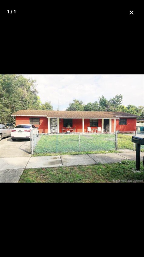
3797 NW 164th St
Miami Gardens, FL 33054
2 Weeks Ago
|
Edit
Favorites
3797 NW 164th St

Favorites
Check Back Soon for Upcoming Availability
| Beds | Baths | Average SF |
|---|---|---|
| 2 Bedrooms 2 Bedrooms 2 Br | 1 Bath 1 Bath 1 Ba | 810 SF |
Fees and Policies
The fees below are based on community-supplied data and may exclude additional fees and utilities.
- Dogs Allowed
-
Fees not specified
-
Weight limit--
-
Pet Limit--
Details
Lease Options
-
12 Month
About This Property
Great home and Great Lot (Duplex) - Large 3-4 car driveway - Large bedrooms - Upgraded Bathroom - Extended private yard - Full Size Washer and Dryer - Close to Palmetto expressway - Immediate Move (No association) - Opa Locka Airport / St Thomas and Florida Memorial University / Amazon Ware House
3797 NW 164Th St is a house located in Miami/Dade County and the 33054 ZIP Code. This area is served by the Miami-Dade County Public Schools attendance zone.
House Features
- Washer/Dryer
Location
Get Directions
Miami Gardens is a vibrant, diverse suburb located midway between Miami and Fort Lauderdale in north central Miami-Dade County, bordering Broward County. Miami Gardens is home to the Hard Rock Stadium, where the Miami Dolphins and the University of Miami Hurricanes play. Calder Race Track is also situated in Miami Gardens.
Miami Gardens contains commercial shopping districts for the furniture and automobile trades along the Palmetto Expressway and U.S. 441, respectively. Saint Thomas University and Florida Memorial University both call Miami Gardens home too. Convenience to I-95, the Palmetto Expressway, and Florida’s Turnpike as well as the Florida East Coast Railway and the South Florida Tri-Rail System makes commuting and traveling from Miami Gardens simple.
Learn more about living in Miami Gardens
Amenities
- Washer/Dryer
Education
| Colleges & Universities | Distance | ||
|---|---|---|---|
| Colleges & Universities | Distance | ||
| Walk: | 9 min | 0.5 mi | |
| Walk: | 16 min | 0.8 mi | |
| Drive: | 9 min | 4.2 mi | |
| Drive: | 13 min | 7.2 mi |
3797 NW 164th St is within 9 minutes or 0.5 mile from Saint Thomas University. It is also near Florida Memorial University and Miami Dade College, North.
Schools


Public Elementary School
Grades PK-5
276 Students
Attendance Zone
Public Middle School
Grades 6-8
453 Students
Attendance Zone
Public High School
Grades 9-12
1,344 Students
Attendance Zone
Private Elementary, Middle & High School
38 Students
Nearby
Private Elementary School
Grades PK-6
Nearby
School data provided by
 The GreatSchools Rating helps parents compare schools within a state based on a variety of school quality indicators and provides a helpful picture of how effectively each school serves all of its students. Ratings are on a scale of 1 (below average) to 10 (above average) and can include test scores, college readiness, academic progress, advanced courses, equity, discipline and attendance data. We also advise parents to visit schools, consider other information on school performance and programs, and consider family needs as part of the school selection process.
View GreatSchools Rating Methodology
Data provided by GreatSchools.org © 2026. All rights reserved.
View GreatSchools Rating Methodology
Data provided by GreatSchools.org © 2026. All rights reserved.
Transportation options available in Miami Gardens include Miami Intl Airport Ground Level, located 10.0 miles from 3797 NW 164th St. 3797 NW 164th St is near Miami International, located 15.4 miles or 27 minutes away, and Fort Lauderdale/Hollywood International, located 16.1 miles or 25 minutes away.
| Transit / Subway | Distance | ||
|---|---|---|---|
| Transit / Subway | Distance | ||
|
Miami Intl Airport Ground Level
|
Drive: | 21 min | 10.0 mi |
|
Airport Station
|
Drive: | 23 min | 10.1 mi |
| Commuter Rail | Distance | ||
|---|---|---|---|
| Commuter Rail | Distance | ||
|
|
Drive: | 5 min | 2.3 mi |
|
|
Drive: | 8 min | 5.1 mi |
|
|
Drive: | 11 min | 6.1 mi |
|
|
Drive: | 12 min | 6.3 mi |
|
|
Drive: | 13 min | 6.5 mi |
| Airports | Distance | ||
|---|---|---|---|
| Airports | Distance | ||
|
Miami International
|
Drive: | 27 min | 15.4 mi |
|
Fort Lauderdale/Hollywood International
|
Drive: | 25 min | 16.1 mi |
Time and distance from 3797 NW 164th St.
| Shopping Centers | Distance | ||
|---|---|---|---|
| Shopping Centers | Distance | ||
| Walk: | 8 min | 0.4 mi | |
| Walk: | 9 min | 0.5 mi | |
| Drive: | 3 min | 1.5 mi |
3797 NW 164th St has 3 shopping centers within 1.5 miles, which is about a 3-minute drive. The miles and minutes will be for the farthest away property.
| Parks and Recreation | Distance | ||
|---|---|---|---|
| Parks and Recreation | Distance | ||
|
Miramar Pineland
|
Drive: | 11 min | 5.2 mi |
|
Greynolds Park
|
Drive: | 17 min | 7.7 mi |
|
Enchanted Forest Elaine Gordon Park
|
Drive: | 15 min | 8.2 mi |
|
Arch Creek Park & Nature Center
|
Drive: | 15 min | 8.3 mi |
|
Oleta River State Park
|
Drive: | 21 min | 9.1 mi |
3797 NW 164th St has 5 parks within 9.1 miles, including Miramar Pineland, Enchanted Forest Elaine Gordon Park, and Arch Creek Park & Nature Center.
| Hospitals | Distance | ||
|---|---|---|---|
| Hospitals | Distance | ||
| Drive: | 11 min | 5.8 mi | |
| Drive: | 13 min | 6.6 mi | |
| Drive: | 13 min | 8.2 mi |
3797 NW 164th St has 3 hospitals within 8.2 miles, the nearest is Hialeah Hospital which is 5.8 miles away and a 11 minute drive.
You May Also Like
Similar Rentals Nearby


What Are Walk Score®, Transit Score®, and Bike Score® Ratings?
Walk Score® measures the walkability of any address. Transit Score® measures access to public transit. Bike Score® measures the bikeability of any address.
What is a Sound Score Rating?
A Sound Score Rating aggregates noise caused by vehicle traffic, airplane traffic and local sources
3797 NW 164th St
Miami Gardens, FL 33054