
The Vitagraph
1277 E 14th St,
Brooklyn, NY 11230
$3,325 - $4,695
1-3 Beds
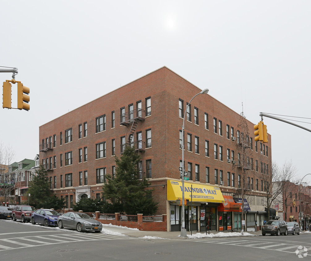
At 375-389 Troy Ave, find a great place to live. Based in Brooklyn's 11213 Zip code, moving to this community offers plenty of nearby experiences. Make sure you to check out the apartment floorplan options. The leasing team is ready to help you find the perfect place. It's time to love where you live. Stop by for a visit today.
375-389 Troy Ave is an apartment community located in Kings County and the 11213 ZIP Code. This area is served by the New York City Geographic District #17 attendance zone.
Air Conditioning
Hardwood Floors
Refrigerator
Tub/Shower
Crown Heights is a central neighborhood in New York’s bustling borough of Brooklyn. Just minutes from the Brooklyn Botanic Garden and the Brooklyn Museum, Crown Heights’ residents have convenient access to some of Brooklyn’s greatest attractions.
Take the whole family to the Brooklyn Children’s Museum to explore the world’s first children’s museum, opened in 1899. Many community parks are available in the neighborhood, such as St. Johns Park, equipped with ball fields, basketball courts, and a recreation center. Enjoy a handcrafted burger paired with a craft beer at Boeuf & Bun, an upbeat local spot in Crown Heights. There’s a variety of apartments and condos available for rent in this central Brooklyn neighborhood.
Learn more about living in Crown HeightsCompare neighborhood and city base rent averages by bedroom.
| Crown Heights | Brooklyn, NY | |
|---|---|---|
| Studio | $2,114 | $2,654 |
| 1 Bedroom | $2,605 | $2,974 |
| 2 Bedrooms | $3,118 | $3,908 |
| 3 Bedrooms | $2,864 | $4,831 |
| Colleges & Universities | Distance | ||
|---|---|---|---|
| Colleges & Universities | Distance | ||
| Drive: | 4 min | 1.1 mi | |
| Drive: | 10 min | 3.0 mi | |
| Drive: | 9 min | 3.2 mi | |
| Drive: | 11 min | 3.9 mi |


Transportation options available in Brooklyn include Crown Heights-Utica Avenue, located 0.5 mile from 375-389 Troy Ave. 375-389 Troy Ave is near LaGuardia, located 10.6 miles or 25 minutes away, and John F Kennedy International, located 10.7 miles or 19 minutes away.
| Transit / Subway | Distance | ||
|---|---|---|---|
| Transit / Subway | Distance | ||
|
|
Walk: | 8 min | 0.5 mi |
|
|
Walk: | 10 min | 0.6 mi |
|
|
Walk: | 16 min | 0.9 mi |
|
|
Walk: | 16 min | 0.9 mi |
|
|
Drive: | 4 min | 1.1 mi |
| Commuter Rail | Distance | ||
|---|---|---|---|
| Commuter Rail | Distance | ||
|
|
Drive: | 6 min | 2.0 mi |
|
|
Drive: | 5 min | 2.3 mi |
|
|
Drive: | 9 min | 3.0 mi |
|
|
Drive: | 20 min | 7.6 mi |
|
|
Drive: | 20 min | 7.9 mi |
| Airports | Distance | ||
|---|---|---|---|
| Airports | Distance | ||
|
LaGuardia
|
Drive: | 25 min | 10.6 mi |
|
John F Kennedy International
|
Drive: | 19 min | 10.7 mi |
Time and distance from 375-389 Troy Ave.
| Shopping Centers | Distance | ||
|---|---|---|---|
| Shopping Centers | Distance | ||
| Walk: | 9 min | 0.5 mi | |
| Walk: | 16 min | 0.9 mi | |
| Drive: | 8 min | 2.9 mi |
| Parks and Recreation | Distance | ||
|---|---|---|---|
| Parks and Recreation | Distance | ||
|
Wingate Park
|
Walk: | 15 min | 0.8 mi |
|
Brooklyn Children's Museum
|
Drive: | 5 min | 1.2 mi |
|
St. John's Park
|
Drive: | 4 min | 1.2 mi |
|
Brooklyn Botanic Garden
|
Drive: | 5 min | 1.4 mi |
|
Betsy Head Memorial Playground
|
Drive: | 5 min | 1.9 mi |
| Hospitals | Distance | ||
|---|---|---|---|
| Hospitals | Distance | ||
| Walk: | 10 min | 0.6 mi | |
| Walk: | 18 min | 0.9 mi | |
| Drive: | 3 min | 1.1 mi |
| Military Bases | Distance | ||
|---|---|---|---|
| Military Bases | Distance | ||
| Drive: | 23 min | 8.5 mi | |
| Drive: | 20 min | 9.2 mi |
What Are Walk Score®, Transit Score®, and Bike Score® Ratings?
Walk Score® measures the walkability of any address. Transit Score® measures access to public transit. Bike Score® measures the bikeability of any address.
What is a Sound Score Rating?
A Sound Score Rating aggregates noise caused by vehicle traffic, airplane traffic and local sources

375-389 Troy Ave
Brooklyn, NY 11213


