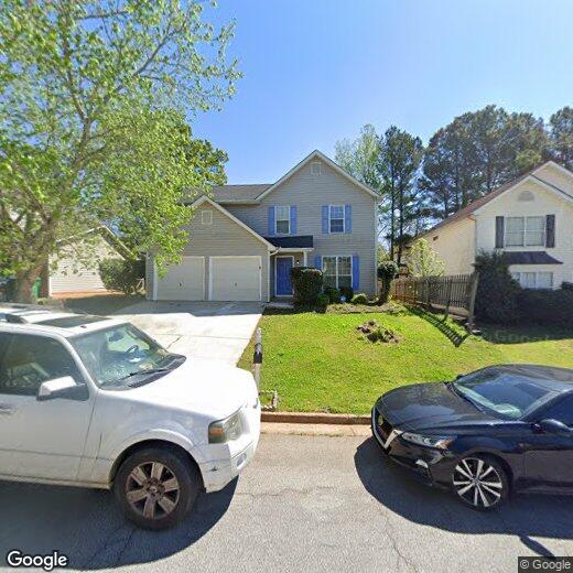

3730 Ozmer Ct
3730 Ozmer Ct
Decatur, GA 30034
2 Weeks Ago
|
Edit
Favorites
3730 Ozmer Ct

Favorites
Check Back Soon for Upcoming Availability
Location
Get Directions
Located just five miles northeast of downtown Atlanta, Decatur offers a blend of historic charm and contemporary living. The city's pedestrian-friendly downtown, anchored by the courthouse square, features independent shops and restaurants. Current rental trends show moderate stability in the market, with one-bedroom units averaging $1,367 and two-bedroom homes at $1,550, experiencing slight decreases of 2.32% and 1.42% respectively over the past year. Housing options range from historic homes in the MAK Historic District to apartment communities near the three MARTA rail stations, providing convenient access to downtown Atlanta.
The city is home to Agnes Scott College and Columbia Theological Seminary, adding to its educational landscape. Residents enjoy outdoor spaces like the 7-acre Woodlands Garden and the historic Decatur Cemetery, established in 1823. The Oakhurst and Winnona Park areas feature tree-lined streets and classic architecture.
Learn more about living in Decatur
Education
| Colleges & Universities | Distance | ||
|---|---|---|---|
| Colleges & Universities | Distance | ||
| Drive: | 7 min | 2.3 mi | |
| Drive: | 17 min | 8.2 mi | |
| Drive: | 23 min | 9.9 mi | |
| Drive: | 19 min | 11.1 mi |
3730 Ozmer Ct is within 7 minutes or 2.3 miles from Georgia Perim. Coll., Decatur. It is also near Agnes Scott College and Clayton State University.
Transportation options available in Decatur include Indian Creek, located 8.7 miles from 3730 Ozmer Ct. 3730 Ozmer Ct is near Hartsfield - Jackson Atlanta International, located 14.4 miles or 25 minutes away.
| Transit / Subway | Distance | ||
|---|---|---|---|
| Transit / Subway | Distance | ||
|
|
Drive: | 14 min | 8.7 mi |
|
|
Drive: | 19 min | 9.1 mi |
|
|
Drive: | 19 min | 9.5 mi |
|
|
Drive: | 16 min | 9.7 mi |
|
|
Drive: | 19 min | 11.3 mi |
| Commuter Rail | Distance | ||
|---|---|---|---|
| Commuter Rail | Distance | ||
|
|
Drive: | 27 min | 16.4 mi |
| Airports | Distance | ||
|---|---|---|---|
| Airports | Distance | ||
|
Hartsfield - Jackson Atlanta International
|
Drive: | 25 min | 14.4 mi |
Time and distance from 3730 Ozmer Ct.
| Shopping Centers | Distance | ||
|---|---|---|---|
| Shopping Centers | Distance | ||
| Drive: | 6 min | 2.3 mi | |
| Drive: | 6 min | 2.5 mi | |
| Drive: | 6 min | 2.5 mi |
3730 Ozmer Ct has 3 shopping centers within 2.5 miles, which is about a 6-minute drive. The miles and minutes will be for the farthest away property.
| Parks and Recreation | Distance | ||
|---|---|---|---|
| Parks and Recreation | Distance | ||
|
Ferns of the World Garden
|
Drive: | 4 min | 1.7 mi |
|
Wylde Center and Oakhurst Community Garden
|
Drive: | 16 min | 7.9 mi |
|
Panola Mountain State Park
|
Drive: | 16 min | 8.3 mi |
|
Bradley Observatory
|
Drive: | 17 min | 8.4 mi |
|
South River Watershed Alliance
|
Drive: | 19 min | 9.1 mi |
3730 Ozmer Ct has 5 parks within 9.1 miles, including Ferns of the World Garden, Panola Mountain State Park, and Wylde Center and Oakhurst Community Garden.
| Hospitals | Distance | ||
|---|---|---|---|
| Hospitals | Distance | ||
| Drive: | 5 min | 2.1 mi | |
| Drive: | 16 min | 9.2 mi | |
| Drive: | 20 min | 10.2 mi |
3730 Ozmer Ct has 3 hospitals within 10.2 miles, the nearest is Georgia Regional Hospital Atlanta which is 2.1 miles away and a 5 minute drive.
| Military Bases | Distance | ||
|---|---|---|---|
| Military Bases | Distance | ||
| Drive: | 19 min | 7.9 mi | |
| Drive: | 28 min | 16.8 mi |
3730 Ozmer Ct is 7.9 miles from Fort Gillem, and is convenient to other military bases, including Fort McPherson.
You May Also Like
Similar Rentals Nearby
-
-

-
-
1 / 58

-
-
-
-
-
-


What Are Walk Score®, Transit Score®, and Bike Score® Ratings?
Walk Score® measures the walkability of any address. Transit Score® measures access to public transit. Bike Score® measures the bikeability of any address.
What is a Sound Score Rating?
A Sound Score Rating aggregates noise caused by vehicle traffic, airplane traffic and local sources