
Living at Santa Monica
1519 6th St,
Santa Monica, CA 90401
Studio - 2 Beds $2,542 - $4,938

Beautiful 3 Bed / 2 Bath - 5 Minutes from Downtown Los Angeles - Brand New Beautiful 3 Bed / 2 Bath - 5 Minutes from Downtown Los Angeles New apartment complex on Percy St. with 3 bedroom and 2 bath 1,077 square feet units located in Boyle Heights, near DTLA. Rentals are outfitted with all-new - Modern finishes - New stainless steel appliances - Kitchen appliances - New washer and dryer - 2 tandem parking spots for each unit - Recessed lights - Wood style flooring - Quartz counters - Pet Friendly Conveniently located near - CSULA, USC Medical Center where the 5, 60, 10, and 101 freeways meet, this neighborhood is conveniently located. Nearby things to do: Find live Mariachi music in the town square, walk to some of the best LA food in the city. Steps away from several schools and the public library. Accessible to: Metro Gold Line from the Indiana/Cesar Chavez station. Boyle Heights is a downtown adjacent East LA neighborhood bustling with life. It is an area with many families and a strong cultural roots. Applications are currently being accepted. All applicants will require a background check and credit check upon application. 3632 1/2 Percy St, Los Angeles, CA 90023 For more information or to book a tour Contact Stephanie : stephanie@archwaysmanagement.com 818-741-6125 - Security Deposit on approved credit only. Actual security deposit subject to change based on credit worthiness. - Pictures are from similar units actual unit may vary. *This property is professionally managed by Archways Property Management (RLNE4929538)
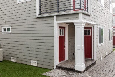
3648-3658 1/2 Percy St is an apartment community located in Los Angeles County and the 90023 ZIP Code. This area is served by the Los Angeles Unified attendance zone.
Washer/Dryer
Air Conditioning
Dishwasher
Microwave
Southeast Los Angeles is directly south of the Fashion District and east of the University of Southern California (USC). This large neighborhood is minutes from downtown Los Angeles, Hollywood, and Beverly Hills, with easy access to the 110 Freeway. This great location places you near sunny beaches, nature trails, and a bevy of leading employers. Students can access both USC and California State University Long Beach from their Southeast LA apartment.
This densely populated, diverse neighborhood features everything from food trucks and corner markets to wide sidewalks and residential areas filled with bungalows, ranch, and Spanish Colonial architecture. Southeast LA features palm trees and mountain views, tampered with gritty undertones to give it a cool, funky vibe.
As for outdoor fun, take your pick between Catalina Island, Venus Beach, or the Santa Monica Pier. Nearby, you’ll find more sunny beaches like White Point, Cabrillo, and Long Beach.
Learn more about living in Southeast Los Angeles| Colleges & Universities | Distance | ||
|---|---|---|---|
| Colleges & Universities | Distance | ||
| Drive: | 8 min | 3.5 mi | |
| Drive: | 6 min | 3.7 mi | |
| Drive: | 10 min | 4.7 mi | |
| Drive: | 10 min | 5.0 mi |


Transportation options available in Los Angeles include Indiana, located 0.8 mile from 3648-3658 1/2 Percy St. 3648-3658 1/2 Percy St is near Long Beach (Daugherty Field), located 17.9 miles or 27 minutes away, and Los Angeles International, located 18.7 miles or 30 minutes away.
| Transit / Subway | Distance | ||
|---|---|---|---|
| Transit / Subway | Distance | ||
|
|
Walk: | 15 min | 0.8 mi |
| Drive: | 4 min | 2.0 mi | |
|
|
Drive: | 4 min | 2.1 mi |
|
|
Drive: | 6 min | 2.5 mi |
|
|
Drive: | 5 min | 3.2 mi |
| Commuter Rail | Distance | ||
|---|---|---|---|
| Commuter Rail | Distance | ||
|
|
Drive: | 8 min | 4.5 mi |
|
|
Drive: | 10 min | 4.5 mi |
|
|
Drive: | 10 min | 4.6 mi |
|
|
Drive: | 9 min | 5.5 mi |
| Drive: | 11 min | 8.4 mi |
| Airports | Distance | ||
|---|---|---|---|
| Airports | Distance | ||
|
Long Beach (Daugherty Field)
|
Drive: | 27 min | 17.9 mi |
|
Los Angeles International
|
Drive: | 30 min | 18.7 mi |
Time and distance from 3648-3658 1/2 Percy St.
| Shopping Centers | Distance | ||
|---|---|---|---|
| Shopping Centers | Distance | ||
| Walk: | 15 min | 0.8 mi | |
| Walk: | 17 min | 0.9 mi | |
| Walk: | 18 min | 1.0 mi |
| Parks and Recreation | Distance | ||
|---|---|---|---|
| Parks and Recreation | Distance | ||
|
Hollenbeck Lake
|
Drive: | 5 min | 3.0 mi |
|
Augustus Hawkins Natural Park
|
Drive: | 10 min | 6.1 mi |
|
Vista Hermosa Natural Park
|
Drive: | 10 min | 6.1 mi |
|
Echo Park Lake
|
Drive: | 9 min | 6.1 mi |
|
Elysian Park
|
Drive: | 15 min | 7.5 mi |
| Hospitals | Distance | ||
|---|---|---|---|
| Hospitals | Distance | ||
| Walk: | 12 min | 0.6 mi | |
| Walk: | 16 min | 0.8 mi | |
| Drive: | 7 min | 4.1 mi |
| Military Bases | Distance | ||
|---|---|---|---|
| Military Bases | Distance | ||
| Drive: | 28 min | 19.4 mi | |
| Drive: | 31 min | 21.5 mi |
What Are Walk Score®, Transit Score®, and Bike Score® Ratings?
Walk Score® measures the walkability of any address. Transit Score® measures access to public transit. Bike Score® measures the bikeability of any address.
What is a Sound Score Rating?
A Sound Score Rating aggregates noise caused by vehicle traffic, airplane traffic and local sources
3648-3658 1/2 Percy St
Los Angeles, CA 90023


 - AVA Burbank")
