$1,695
/ Month
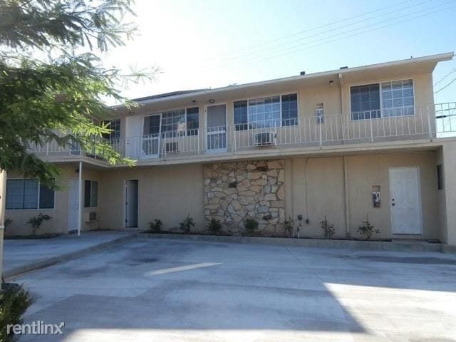
353 W Alameda Ave
Burbank, CA 91506
2 Weeks Ago
|
Edit
Favorites
353 W Alameda Ave

Favorites
Check Back Soon for Upcoming Availability
| Beds | Baths | Average SF |
|---|---|---|
| 1 Bedroom 1 Bedroom 1 Br | 1 Bath 1 Bath 1 Ba | — |
Fees and Policies
The fees below are based on community-supplied data and may exclude additional fees and utilities.
- Dogs Allowed
-
Fees not specified
- Cats Allowed
-
Fees not specified
Details
Utilities Included
-
Water
About This Property
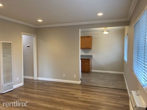
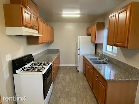
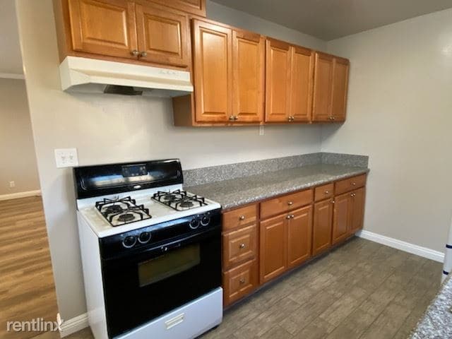
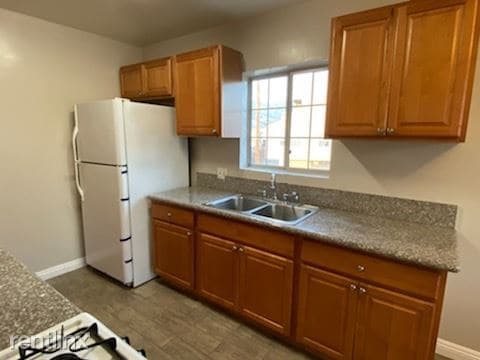
(818) 376-9102 - Bright Spacious Upper Corner apt in Burbank - Property Id: 187381 353 W. ALAMEDA AVE BURBANK CA 91506 Bright Spacious Upper Corner unit 1 Bed 1 Bath approximately 650 SQFT Wood Laminate Flooring Air conditioned / Ceiling Fan Recessed Lighting Granite Counter top Refrigerator / Stove Street Parking Only Water & Gas paid One year lease Laundry on premises 1 small pet ok with additional deposit 818 376 9102 www.RealtySourceListings.com Apply at TurboTenant: http://rental.turbotenant.com/properties/187381 Property Id 187381 (RLNE5375891) Other Amenities: Other (Cable Ready). Appliances: Refrigerator, Range, Oven, Garbage Disposal, Other (Freezer). Lease lengths: 12 Months. Utilities: Water Included. Pet policies: Small Dogs Allowed, Cats Allowed.
353 W Alameda Ave is an apartment community located in Los Angeles County and the 91506 ZIP Code.
Unique Features
- Oven, Appliances - Freezer, Amenities - Cable Ready, Amenities - Cooling System: Wall, Amenities - F
Location
Get Directions
Rancho Adjacent, near the center of Burbank, combines a mixture of single-family homes, apartments, small and large commercial areas, industrial zones, and city government buildings. Residents enjoy the convenience of having a variety goods and services within a short drive. Rancho Adjacent borders the horse-oriented neighborhood known as Rancho just south of the community.
Bordered by Verdugo and Alameda Avenues, Rancho Adjacent stretches from Hollywood Way across Interstate 5 to Glenoaks Boulevard. Olive Avenue cuts diagonally through the neighborhood and is lined with restaurants and small businesses. Rancho Adjacent also lies just north of the Ventura Freeway, a major east-west link across the San Fernando Valley. Downtown Los Angeles rests 13 miles south of Rancho Adjacent, making this compact community a great choice no matter where your commute takes you.
Learn more about living in Rancho AdjacentBelow are rent ranges for similar nearby apartments
Amenities
- Oven, Appliances - Freezer, Amenities - Cable Ready, Amenities - Cooling System: Wall, Amenities - F
Expenses
Utilities Included
Water
Included
Education
| Colleges & Universities | Distance | ||
|---|---|---|---|
| Colleges & Universities | Distance | ||
| Drive: | 4 min | 2.1 mi | |
| Drive: | 8 min | 4.4 mi | |
| Drive: | 9 min | 5.7 mi | |
| Drive: | 11 min | 6.0 mi |
353 W Alameda Ave is within 4 minutes or 2.1 miles from New York Film Academy. It is also near Woodbury University and Glendale Community College.
Transportation options available in Burbank include Universal City/Studio City, located 4.6 miles from 353 W Alameda Ave. 353 W Alameda Ave is near Bob Hope, located 6.2 miles or 11 minutes away, and Los Angeles International, located 27.6 miles or 38 minutes away.
| Transit / Subway | Distance | ||
|---|---|---|---|
| Transit / Subway | Distance | ||
|
|
Drive: | 8 min | 4.6 mi |
|
|
Drive: | 8 min | 5.0 mi |
|
|
Drive: | 11 min | 5.9 mi |
|
|
Drive: | 11 min | 6.3 mi |
|
|
Drive: | 11 min | 7.4 mi |
| Commuter Rail | Distance | ||
|---|---|---|---|
| Commuter Rail | Distance | ||
|
|
Drive: | 3 min | 1.3 mi |
| Drive: | 6 min | 4.0 mi | |
|
|
Drive: | 8 min | 4.2 mi |
|
|
Drive: | 8 min | 5.4 mi |
|
|
Drive: | 9 min | 5.7 mi |
| Airports | Distance | ||
|---|---|---|---|
| Airports | Distance | ||
|
Bob Hope
|
Drive: | 11 min | 6.2 mi |
|
Los Angeles International
|
Drive: | 38 min | 27.6 mi |
Time and distance from 353 W Alameda Ave.
| Shopping Centers | Distance | ||
|---|---|---|---|
| Shopping Centers | Distance | ||
| Walk: | 6 min | 0.3 mi | |
| Walk: | 7 min | 0.4 mi | |
| Walk: | 9 min | 0.5 mi |
353 W Alameda Ave has 3 shopping centers within 0.5 mile, which is about a 9-minute walk. The miles and minutes will be for the farthest away property.
| Parks and Recreation | Distance | ||
|---|---|---|---|
| Parks and Recreation | Distance | ||
|
Los Angeles Zoo
|
Drive: | 13 min | 3.9 mi |
|
Runyon Canyon
|
Drive: | 13 min | 6.4 mi |
|
Bird Sanctuary
|
Drive: | 11 min | 6.4 mi |
|
Griffith Observatory
|
Drive: | 15 min | 7.6 mi |
|
Griffith Park
|
Drive: | 24 min | 9.8 mi |
353 W Alameda Ave has 5 parks within 9.8 miles, including Los Angeles Zoo, Griffith Park, and Griffith Observatory.
| Hospitals | Distance | ||
|---|---|---|---|
| Hospitals | Distance | ||
| Drive: | 2 min | 1.2 mi | |
| Drive: | 7 min | 5.1 mi | |
| Drive: | 9 min | 6.0 mi |
353 W Alameda Ave has 3 hospitals within 6.0 miles, the nearest is Providence Saint Joseph Medical Center which is 1.2 miles away and a 2 minute drive.
| Military Bases | Distance | ||
|---|---|---|---|
| Military Bases | Distance | ||
| Drive: | 35 min | 27.0 mi |
353 W Alameda Ave is 27.0 miles and a 35 minute drive from Los Angeles Air Force Base.
You May Also Like
Similar Rentals Nearby


What Are Walk Score®, Transit Score®, and Bike Score® Ratings?
Walk Score® measures the walkability of any address. Transit Score® measures access to public transit. Bike Score® measures the bikeability of any address.
What is a Sound Score Rating?
A Sound Score Rating aggregates noise caused by vehicle traffic, airplane traffic and local sources

353 W Alameda Ave
Burbank, CA 91506