
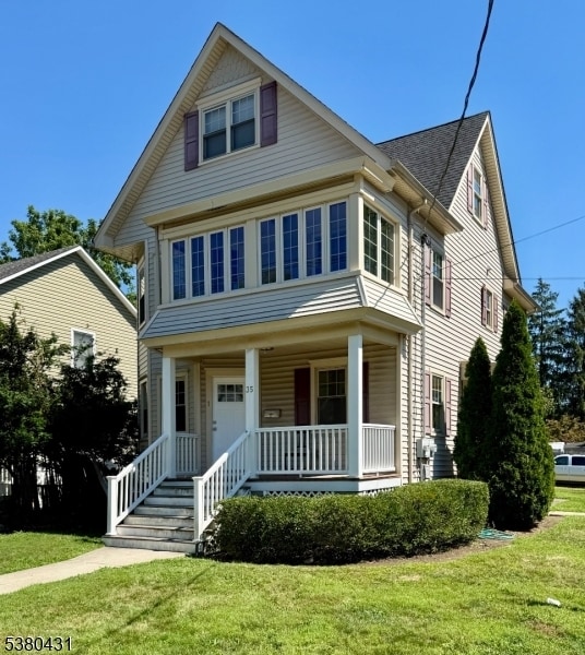
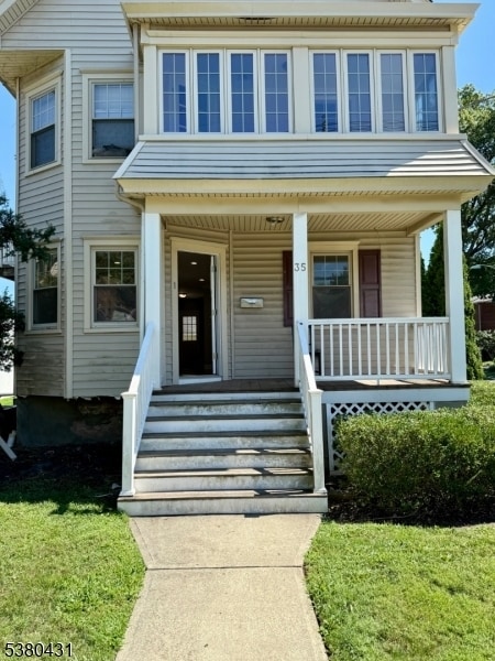
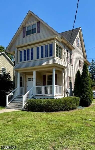
35 Burnside Ave
Cranford, NJ 07016
-
Bedrooms
2
-
Bathrooms
1
-
Square Feet
--
-
Available
Available Now
Highlight
- Controlled Access

About This Home
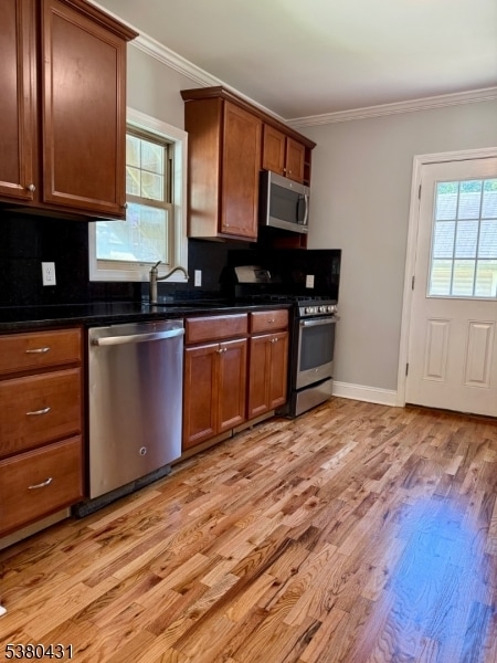
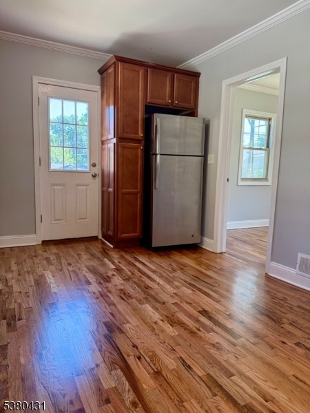
Looking for a 2 bedroom apartment near downtown Cranford? This first floor unit fits the bill! Charming front porch, driveway parking, quiet neighborhood, just .5 miles to the Cranford train station and downtown. This unit is light, bright, and freshly painted with updated kitchen and bathroom, super convenient and easy. Recessed lighting, modern appliances, beautifully re-finished hardwood floors team up with old charm and character, making this a super convenient option.
35 Burnside Ave is a house located in Union County and the 07016 ZIP Code. This area is served by the Cranford Public attendance zone.
House Features
- Air Conditioning
- Tile Floors
- Package Service
- Laundry Facilities
- Controlled Access
Fees and Policies
The fees below are based on community-supplied data and may exclude additional fees and utilities.
Contact
- Phone Number
- Website View Property Website
- Contact
-
Source

- Air Conditioning
- Tile Floors
- Package Service
- Laundry Facilities
- Controlled Access
Cranford is a peaceful suburb situated in the heart of Union County. Lush with township and county parks as well as the Rahway River Parkway, Cranford offers ample opportunities to engage in outdoor recreation and connect with nature. Cranford is also home to the last working farm in Union County, Dreyer Farms, which provides fresh produce in addition to hosting a variety of special events.
Cranford’s vibrant downtown area contains a slew of restaurants, specialty shops, cafes, and art galleries in colorful buildings, serving as a gathering place for the close-knit community. Commuting and traveling from Cranford is easy with access to the NJ Transit bus, Raritan Valley train line, and the Garden State Parkway. New York City and its many dynamic amenities are less than an hour’s drive or train ride away from Cranford.
Learn more about living in Cranford| Colleges & Universities | Distance | ||
|---|---|---|---|
| Colleges & Universities | Distance | ||
| Drive: | 8 min | 2.3 mi | |
| Drive: | 13 min | 5.6 mi | |
| Drive: | 14 min | 6.9 mi | |
| Drive: | 17 min | 7.2 mi |


View GreatSchools Rating Methodology
Data provided by GreatSchools.org © 2025. All rights reserved.
Transportation options available in Cranford include Warren Street, located 10.7 miles from 35 Burnside Ave. 35 Burnside Ave is near Newark Liberty International, located 12.4 miles or 19 minutes away, and LaGuardia, located 31.6 miles or 53 minutes away.
| Transit / Subway | Distance | ||
|---|---|---|---|
| Transit / Subway | Distance | ||
|
|
Drive: | 18 min | 10.7 mi |
|
|
Drive: | 18 min | 10.7 mi |
|
|
Drive: | 18 min | 10.9 mi |
|
|
Drive: | 18 min | 11.2 mi |
|
|
Drive: | 18 min | 11.5 mi |
| Commuter Rail | Distance | ||
|---|---|---|---|
| Commuter Rail | Distance | ||
|
|
Walk: | 13 min | 0.7 mi |
|
|
Walk: | 15 min | 0.8 mi |
|
|
Drive: | 5 min | 2.1 mi |
|
|
Drive: | 9 min | 3.4 mi |
|
|
Drive: | 10 min | 4.8 mi |
| Airports | Distance | ||
|---|---|---|---|
| Airports | Distance | ||
|
Newark Liberty International
|
Drive: | 19 min | 12.4 mi |
|
LaGuardia
|
Drive: | 53 min | 31.6 mi |
Time and distance from 35 Burnside Ave.
| Shopping Centers | Distance | ||
|---|---|---|---|
| Shopping Centers | Distance | ||
| Walk: | 5 min | 0.3 mi | |
| Walk: | 9 min | 0.5 mi | |
| Walk: | 12 min | 0.7 mi |
| Parks and Recreation | Distance | ||
|---|---|---|---|
| Parks and Recreation | Distance | ||
|
William Miller Sperry Observatory
|
Drive: | 6 min | 2.2 mi |
|
Trailside Museum Watchung Reservation
|
Drive: | 13 min | 4.6 mi |
|
Hawk Rise Sanctuary
|
Drive: | 15 min | 5.9 mi |
|
Cora Hartshorn Arboretum
|
Drive: | 19 min | 7.7 mi |
|
Merrill Park
|
Drive: | 17 min | 9.0 mi |
| Hospitals | Distance | ||
|---|---|---|---|
| Hospitals | Distance | ||
| Drive: | 10 min | 3.5 mi | |
| Drive: | 15 min | 6.0 mi | |
| Drive: | 17 min | 7.7 mi |
| Military Bases | Distance | ||
|---|---|---|---|
| Military Bases | Distance | ||
| Drive: | 13 min | 3.4 mi | |
| Drive: | 12 min | 5.1 mi | |
| Drive: | 24 min | 16.2 mi |
35 Burnside Ave Photos
Nearby Apartments
Within 50 Miles of 35 Burnside Ave Cranford, NJ 07016
-
1424 Saint Georges Ave
Avenel, NJ 07001
$3,000
3 Br 4.6 mi
-
621 Greenbrook Rd
North Plainfield, NJ 07063
$3,600
3 Br 8.1 mi
-
657 Amboy Ave
Edison, NJ 08837
$4,500
4 Br 8.4 mi
-
3284 John F Kennedy Blvd
Jersey City, NJ 07306
$2,700
3 Br 14.8 mi
-
23 Cottage Ave
Milltown, NJ 08850
$2,800
2 Br 15.3 mi
-
44 Highland Blvd
Keansburg, NJ 07734
$2,900
3 Br 16.5 mi
What Are Walk Score®, Transit Score®, and Bike Score® Ratings?
Walk Score® measures the walkability of any address. Transit Score® measures access to public transit. Bike Score® measures the bikeability of any address.
What is a Sound Score Rating?
A Sound Score Rating aggregates noise caused by vehicle traffic, airplane traffic and local sources
35 Burnside Ave
Cranford, NJ 07016