
$2,900
Total Monthly Price
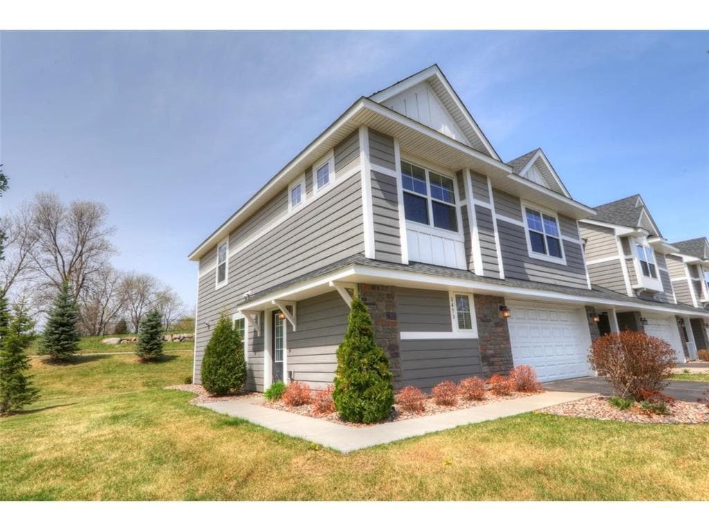
3473 Chestnut Ln
Eagan, MN 55123
Today
Favorites
612-875-7100
-
Bedrooms
3
-
Bathrooms
3
-
Square Feet
1,778 sq ft
-
Available
Available Now
Highlights
- Loft
- 2 Car Attached Garage
- Forced Air Heating and Cooling System
3473 Chestnut Ln

Favorites
About This Home
$2,670 deposit,
Available Now
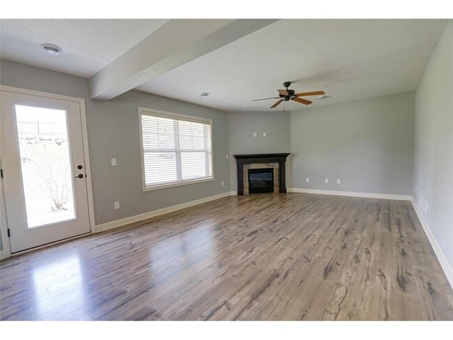
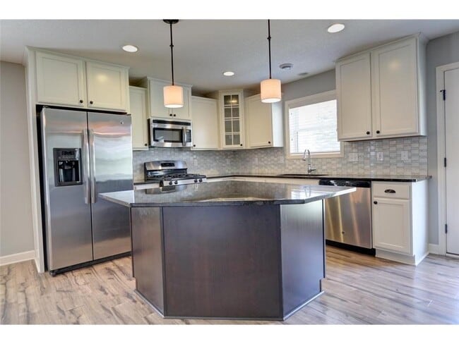
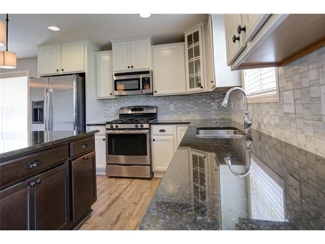
Beautiful 3 Bedroom End unit with OPEN FLOOR PLAN and a lot of amenities! GREAT LOCATION off Yankee Doodle & Lexington. STAINLESS APPLIANCES, laminate wood floors, GRANITE KITCHEN COUNTERTOPS. Living Room includes a lovely FIREPLACE . 196 ISD school district, minutes to airport, 35E and 494! One small dog allowed with approval. Lawn Care, Snow Removal, Trash and High speed internet included, Tenant pays all other utilities. * Application Fee $55 per adult * Lease Processing Administrative Fee $150 * Security Deposit $2,900.00- refundable * Pet Deposit $500-refundable
3473 Chestnut Ln is a townhome located in Dakota County and the 55123 ZIP Code. This area is served by the Rosemount-Apple Valley-Eagan attendance zone.
* Price shown is total price based on community-supplied monthly required fees. Excludes user-selected optional fees and variable or usage-based fees and required charges due at or prior to move-in or at move-out. Price, availability, fees, and any applicable rent special are subject to change without notice.
* Square footage definitions vary. Displayed square footage is approximate.
Home Details
Home Type
Townhome
Year Built
Built in 2014
Bedrooms and Bathrooms
2.5 Bathrooms
3 Bedrooms
Home Design
Pitched Roof
Interior Spaces
Living Room with Fireplace
Loft
1,778 Sq Ft Home
2-Story Property
Kitchen
Cooktop
Microwave
Dishwasher
Disposal
Laundry
Dryer
Washer
Listing and Financial Details
Property Available on 8/5/25
Assessor Parcel Number 107270602080
Parking
2 Car Attached Garage
Garage Door Opener
Utilities
Forced Air Heating and Cooling System
Community Details
Overview
No Home Owners Association
Stonehaven 7Th Add Subdivision
Fees and Policies
The fees below are based on community-supplied data and may exclude additional fees and utilities.
- Parking
-
Garage--
Contact
- Listed by David A. Stish | Homes For Now
- Phone Number
- Contact
-
Source
 NorthstarMLS®
Copyright © 2025 Regional Multiple Listing Service of Minnesota [NorthStarMLS]. All rights reserved. All information provided by the listing agent/broker is deemed reliable but is not guaranteed and should be independently verified.
Location
Get Directions
Amenities
- Washer/Dryer
- Air Conditioning
- Heating
- Fireplace
- Dishwasher
- Disposal
- Eat-in Kitchen
- Microwave
- Range
- Refrigerator
- Breakfast Nook
- Hardwood Floors
- Dining Room
- Walk-In Closets
- Patio
- Porch
Green spaces and recreation areas are all over Eagan, and the southern border of the city is formed by Lebanon Hills Regional Park, which incorporates the Minnesota Zoo and Valleywood Golf Course. Eagan is home to Rasmussen College and Argosy University, with a branch campus of the University of Minnesota just south of town as well.
Eagan is right across the river from the Mall of America and Minneapolis -Saint Paul International Airport, and roughly 15 minutes away from downtown St. Paul and Minneapolis by car (rail service is also available via Minnesota Valley Transit). The close proximity to the Twin Cities combined with the excellent public schools and low crime rate make apartment s in Eagan great for commuters and families.
Learn more about living in Eagan
Education
| Colleges & Universities | Distance | ||
|---|---|---|---|
| Colleges & Universities | Distance | ||
| Drive: | 5 min | 2.5 mi | |
| Drive: | 12 min | 5.7 mi | |
| Drive: | 18 min | 8.9 mi | |
| Drive: | 16 min | 9.9 mi |
3473 Chestnut Ln is within 5 minutes or 2.5 miles from Argosy University, Twin Cities. It is also near Inver Hills Community College and St. Catherine University.
Schools


Public Elementary School
Grades PK-4
392 Students
Nearby
Public Elementary School
Grades K-5
754 Students
Attendance Zone
Public Middle School
Grades 6-8
1,158 Students
Attendance Zone
Public High School
Grades 9-12
2,171 Students
Attendance Zone
Private Elementary & Middle School
Grades PK-8
549 Students
Nearby
Private Middle & High School
Grades 6-12
629 Students
Nearby
School data provided by
 The GreatSchools Rating helps parents compare schools within a state based on a variety of school quality indicators and provides a helpful picture of how effectively each school serves all of its students. Ratings are on a scale of 1 (below average) to 10 (above average) and can include test scores, college readiness, academic progress, advanced courses, equity, discipline and attendance data. We also advise parents to visit schools, consider other information on school performance and programs, and consider family needs as part of the school selection process.
View GreatSchools Rating Methodology
Data provided by GreatSchools.org © 2025. All rights reserved.
View GreatSchools Rating Methodology
Data provided by GreatSchools.org © 2025. All rights reserved.
Transportation options available in Eagan include American Boulevard, located 7.1 miles from 3473 Chestnut Ln. 3473 Chestnut Ln is near Minneapolis-St Paul International/Wold-Chamberlain, located 8.7 miles or 16 minutes away.
| Transit / Subway | Distance | ||
|---|---|---|---|
| Transit / Subway | Distance | ||
|
|
Drive: | 12 min | 7.1 mi |
|
John P Humphrey Interlocking
|
Drive: | 13 min | 7.3 mi |
|
|
Drive: | 13 min | 7.3 mi |
|
|
Drive: | 14 min | 7.7 mi |
|
|
Drive: | 14 min | 7.8 mi |
| Commuter Rail | Distance | ||
|---|---|---|---|
| Commuter Rail | Distance | ||
|
|
Drive: | 17 min | 11.0 mi |
|
|
Drive: | 28 min | 14.2 mi |
|
|
Drive: | 37 min | 22.7 mi |
|
|
Drive: | 48 min | 34.2 mi |
|
|
Drive: | 50 min | 35.9 mi |
| Airports | Distance | ||
|---|---|---|---|
| Airports | Distance | ||
|
Minneapolis-St Paul International/Wold-Chamberlain
|
Drive: | 16 min | 8.7 mi |
Time and distance from 3473 Chestnut Ln.
| Shopping Centers | Distance | ||
|---|---|---|---|
| Shopping Centers | Distance | ||
| Drive: | 3 min | 1.4 mi | |
| Drive: | 4 min | 1.4 mi | |
| Drive: | 4 min | 1.6 mi |
3473 Chestnut Ln has 3 shopping centers within 1.6 miles, which is about a 4-minute drive. The miles and minutes will be for the farthest away property.
| Parks and Recreation | Distance | ||
|---|---|---|---|
| Parks and Recreation | Distance | ||
|
Dodge Nature Center
|
Drive: | 13 min | 7.1 mi |
|
Crosby Farm Regional Park
|
Drive: | 12 min | 7.1 mi |
|
Minnesota Valley Wetland Management District
|
Drive: | 14 min | 7.5 mi |
|
Fort Snelling State Park
|
Drive: | 16 min | 8.3 mi |
|
Minnesota Zoo
|
Drive: | 17 min | 9.1 mi |
3473 Chestnut Ln has 5 parks within 9.1 miles, including Minnesota Valley Wetland Management District, Fort Snelling State Park, and Dodge Nature Center.
| Hospitals | Distance | ||
|---|---|---|---|
| Hospitals | Distance | ||
| Drive: | 16 min | 10.4 mi | |
| Drive: | 17 min | 10.6 mi | |
| Drive: | 17 min | 11.5 mi |
3473 Chestnut Ln has 3 hospitals within 11.5 miles, the nearest is Allina United Hospital which is 10.4 miles away and a 16 minute drive.
| Military Bases | Distance | ||
|---|---|---|---|
| Military Bases | Distance | ||
| Drive: | 14 min | 7.6 mi |
3473 Chestnut Ln is 7.6 miles and a 14 minute drive from Fort Snelling Military Reservation.
You May Also Like
-
Livery Modern Apartments
5076 161st St W
Lakeville, MN 55044
Call for Rent
3 Br 8.2 mi
-
Bentley Village
9392-9485 4th St N
Lake Elmo, MN 55042
$3,100 - $3,670 Total Monthly Price
3-4 Br 13.9 mi
-
City Walk at Woodbury
10225 City Walk Dr
Woodbury, MN 55129
$2,421 - $2,721 Total Monthly Price
3 Br 12 Month Lease 14.2 mi
Similar Rentals Nearby
-
-
-
-
Total Monthly Price New
$1,894 - $2,040
Total Monthly PriceBase Rent$1,849 - $1,995Required Monthly Fees$45Total Monthly Price$1,894 - $2,0403 Beds
Cats Allowed Pool
-
-
-
-
Total Monthly Price New
$2,353 - $9,539
Total Monthly PriceBase Rent$2,349 - $9,535Required Monthly Fees$4Utilities & EssentialsVariesTotal Monthly Price$2,353 - $9,5393-4 Beds
SpecialsPets Allowed Fitness Center Pool Dishwasher In Unit Washer & Dryer Walk-In Closets
-
Total Monthly Price New
$2,971 - $4,796
Total Monthly PriceBase Rent$2,865 - $4,690Required Monthly Fees$106Utilities & EssentialsVariesTotal Monthly Price$2,971 - $4,7963 Beds
SpecialsPets Allowed Fitness Center Pool In Unit Washer & Dryer Business Center Package Service
-


What Are Walk Score®, Transit Score®, and Bike Score® Ratings?
Walk Score® measures the walkability of any address. Transit Score® measures access to public transit. Bike Score® measures the bikeability of any address.
What is a Sound Score Rating?
A Sound Score Rating aggregates noise caused by vehicle traffic, airplane traffic and local sources
3473 Chestnut Ln
Eagan, MN 55123