-
Exterior Front View
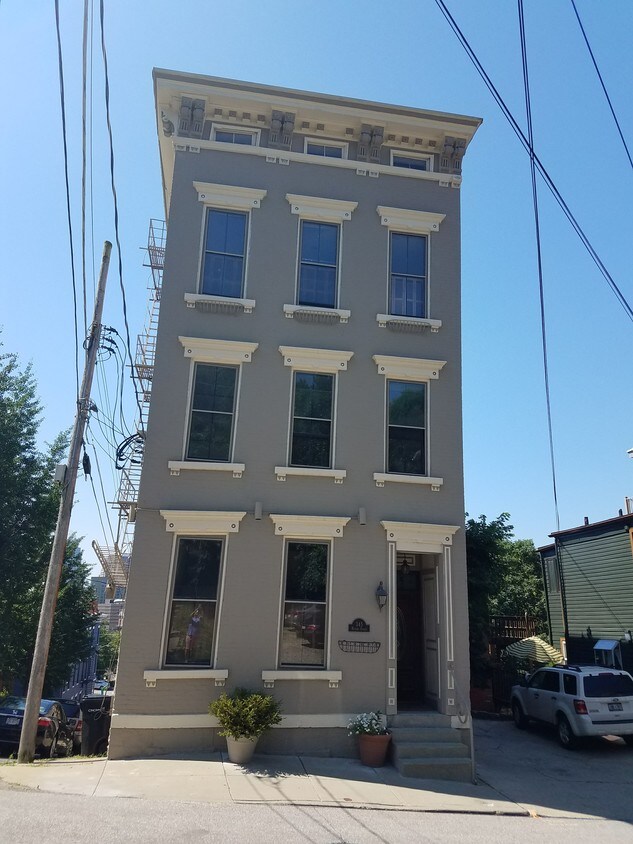
345 Milton St
345 Milton St,
Cincinnati,
OH
45202
2 Weeks Ago
Favorites
345 Milton St

Favorites
Check Back Soon for Upcoming Availability
Fees and Policies
The fees below are based on community-supplied data and may exclude additional fees and utilities.
- Parking
-
Street--
Details
Lease Options
-
12 Months
About 345 Milton St Cincinnati, OH 45202
Newly renovated 2-bedroom apartment in the heart of Mt. Auburn's Historic District- Prospect Hill. Unique floor plan with 1-large/1-smaller bedroom/office. Optimal for couples and/or single applicant looking for additional space. Apartment has an abundance of natural light, new appliances and modern finishes. Great location, minutes from downtown Cincinnati, UC and OTR. Please note- No cats permitted.
345 Milton St is an apartment community located in Hamilton County and the 45202 ZIP Code.
Apartment Features
- Smoke Free
- Laundry Facilities
Location
Get Directions
The Cincinnati neighborhood of Mount Auburn sits north of downtown and west of Interstate 71. The neighborhood, originally a hilltop escape from the crowded conditions of lower Downtown Cincinnati, gained national recognition as a historic district in 1973. The well-known community contains beautiful mansions dating back to 1819, including the home of former President William Howard Taft.
The community contains beautiful mansions formerly owned by a host of prominent residents. A number of historic buildings and sites dot the area, including the Mount Auburn Young Ladies Institute. The neighborhood also features the beloved ice cream parlor Graeter's Confectionary, as well as Christ Hospital.
Learn more about living in Mount AuburnBelow are rent ranges for similar nearby apartments
| Beds | Average Size | Lowest | Typical | Premium |
|---|---|---|---|---|
| Studio Studio Studio | 508-511 Sq Ft | $815 | $1,355 | $1,876 |
| 1 Bed 1 Bed 1 Bed | 744-746 Sq Ft | $700 | $1,760 | $3,320 |
| 2 Beds 2 Beds 2 Beds | 1114-1117 Sq Ft | $550 | $2,430 | $4,275 |
| 3 Beds 3 Beds 3 Beds | 1548-1555 Sq Ft | $950 | $3,325 | $8,550 |
| 4 Beds 4 Beds 4 Beds | 1991 Sq Ft | $800 | $2,716 | $26,470 |
Amenities
- Smoke Free
- Laundry Facilities
Education
| Colleges & Universities | Distance | ||
|---|---|---|---|
| Colleges & Universities | Distance | ||
| Drive: | 6 min | 1.9 mi | |
| Drive: | 7 min | 2.2 mi | |
| Drive: | 11 min | 4.0 mi | |
| Drive: | 10 min | 4.2 mi |
345 Milton St is within 6 minutes or 1.9 miles from University of Cincinnati. It is also near Univ. of Cincinnati, Medical and Cincinnati State.
Transportation options available in Cincinnati include Hanke Exchange Station, 12Th & Main, located 0.5 mile from 345 Milton St. 345 Milton St is near Cincinnati/Northern Kentucky International, located 15.3 miles or 30 minutes away.
| Transit / Subway | Distance | ||
|---|---|---|---|
| Transit / Subway | Distance | ||
| Walk: | 9 min | 0.5 mi | |
| Walk: | 10 min | 0.5 mi | |
| Walk: | 11 min | 0.6 mi | |
| Walk: | 13 min | 0.7 mi | |
| Walk: | 13 min | 0.7 mi |
| Commuter Rail | Distance | ||
|---|---|---|---|
| Commuter Rail | Distance | ||
|
|
Drive: | 6 min | 1.9 mi |
| Airports | Distance | ||
|---|---|---|---|
| Airports | Distance | ||
|
Cincinnati/Northern Kentucky International
|
Drive: | 30 min | 15.3 mi |
Time and distance from 345 Milton St.
| Shopping Centers | Distance | ||
|---|---|---|---|
| Shopping Centers | Distance | ||
| Drive: | 4 min | 1.2 mi | |
| Drive: | 4 min | 1.3 mi | |
| Drive: | 5 min | 2.3 mi |
345 Milton St has 3 shopping centers within 2.3 miles, which is about a 5-minute drive. The miles and minutes will be for the farthest away property.
| Parks and Recreation | Distance | ||
|---|---|---|---|
| Parks and Recreation | Distance | ||
|
William H. Taft National Historic Site
|
Walk: | 11 min | 0.6 mi |
|
Krohn Conservatory
|
Drive: | 4 min | 1.6 mi |
|
Theodore M. Berry Friendship Park
|
Drive: | 5 min | 1.7 mi |
|
Eden Park
|
Drive: | 5 min | 1.8 mi |
|
John G. & Phyllis W. Smale Riverfront Park
|
Drive: | 6 min | 2.1 mi |
345 Milton St has 5 parks within 2.1 miles, including William H. Taft National Historic Site, Krohn Conservatory, and Eden Park.
| Hospitals | Distance | ||
|---|---|---|---|
| Hospitals | Distance | ||
| Walk: | 13 min | 0.7 mi | |
| Drive: | 6 min | 1.9 mi | |
| Drive: | 6 min | 2.3 mi |
345 Milton St has 3 hospitals within 2.3 miles, the nearest is Christ Hospital which is 0.7 mile away and a 13 minute walk.
| Military Bases | Distance | ||
|---|---|---|---|
| Military Bases | Distance | ||
| Drive: | 73 min | 53.1 mi | |
| Drive: | 79 min | 58.2 mi | |
| Drive: | 82 min | 61.4 mi |
345 Milton St has 3 military bases within 61.4 miles, the nearest is Gentile Air Force Station which is 53.1 miles away and a 73 minute drive.
You May Also Like
Similar Rentals Nearby


What Are Walk Score®, Transit Score®, and Bike Score® Ratings?
Walk Score® measures the walkability of any address. Transit Score® measures access to public transit. Bike Score® measures the bikeability of any address.
What is a Sound Score Rating?
A Sound Score Rating aggregates noise caused by vehicle traffic, airplane traffic and local sources