$3,500
/ Month
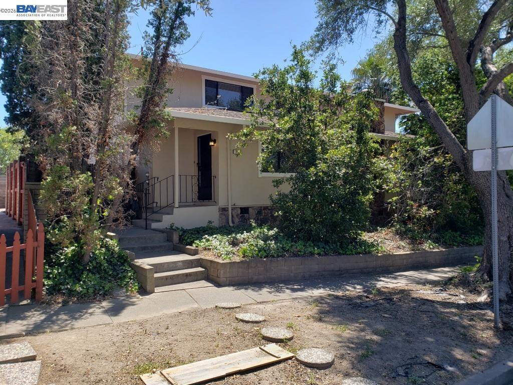
342 Washington Blvd
Fremont, CA 94539
Favorites
510-494-9018
-
Bedrooms
3
-
Bathrooms
2.5
-
Square Feet
1,480 sq ft
-
Available
Available Now
Highlights
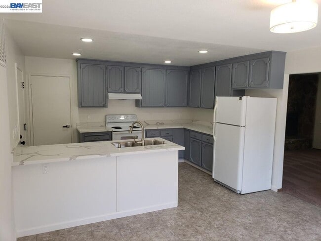
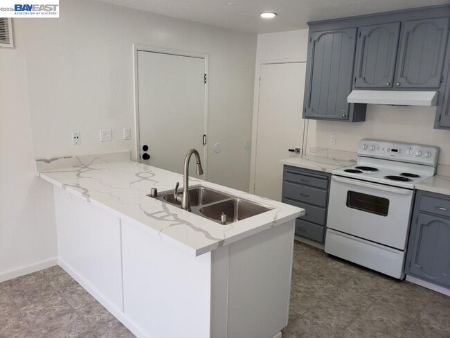
- Solid Surface Countertops
- 2 Car Attached Garage
- Forced Air Heating System
- Carpet
- Vinyl Flooring
342 Washington Blvd

Favorites
About This Home
Available Now
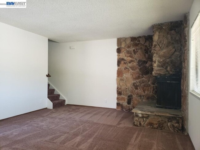
This spacious 3 bedroom,2 & 1/2 bath,and 2 car attached garage duplex home is located in a great location,the Mission area of Fremont. This excellent home has 1480 sq. ft. of living space which includes a updated kitchen and dining area,a large front living room with big windows looking out the front yard and three big bedrooms,including a master suite with a private bath.
342 Washington Blvd is a townhome located in Alameda County and the 94539 ZIP Code. This area is served by the Fremont Unified School District attendance zone.
* Price shown is base rent. Excludes user-selected optional fees and variable or usage-based fees and required charges due at or prior to move-in or at move-out. Price, availability, fees, and any applicable rent special are subject to change without notice.
* Square footage definitions vary. Displayed square footage is approximate.
Home Details
Home Type
Duplex
Year Built
Built in 1979
Bedrooms and Bathrooms
2.5 Bathrooms
3 Bedrooms
Flooring
Carpet
Vinyl
Home Design
Composition Shingle Roof
Stucco
Interior Spaces
Living Room with Fireplace
2-Story Property
Kitchen
Solid Surface Countertops
Dishwasher
Laundry
Washer and Dryer Hookup
Listing and Financial Details
Assessor Parcel Number 513608179
Lot Details
8,445 Sq Ft Lot
Parking
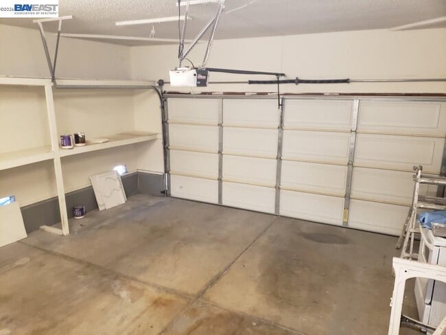
2 Car Attached Garage
Garage Door Opener
Utilities
Forced Air Heating System
Community Details
Overview
No Home Owners Association
Mission Area Subdivision
Pet Policy
No Pets Allowed
Contact
- Listed by Rich Oliver | Property Care Inc.
- Phone Number
- Contact
-
Source
 Bay East Association of REALTORS ®
Copyright© 2026 Bay East, Contra Costa, bridgeMLS. All rights reserved. All information provided by the listing agent/broker is deemed reliable but is not guaranteed and should be independently verified.
Location
Get Directions
Fremont, positioned in the San Francisco Bay Area, combines suburban living with innovation and technology. As home to the Tesla Factory, the city maintains a strong industrial presence while offering numerous parks and outdoor spaces. Lake Elizabeth in Central Park provides recreational opportunities, while Mission Peak's trails showcase panoramic Bay Area views. The rental market remains competitive, with average rents ranging from $2,204 for studios to $3,770 for three-bedroom homes, with year-over-year increases between 1.5% and 4.4%.
The city's five districts each offer distinct characteristics. Historic Niles preserves its early film industry heritage, while Mission San Jose features the restored Mission San José, an architectural landmark from 1797. The Warm Springs area has developed into a technology center, and Central Fremont includes shopping destinations like the Fremont Hub and Pacific Commons.
Learn more about living in Fremont
Education
| Colleges & Universities | Distance | ||
|---|---|---|---|
| Colleges & Universities | Distance | ||
| Walk: | 18 min | 1.0 mi | |
| Drive: | 12 min | 5.8 mi | |
| Drive: | 18 min | 11.2 mi | |
| Drive: | 25 min | 12.9 mi |
342 Washington Blvd is within 18 minutes or 1.0 mile from Ohlone College, Fremont Campus. It is also near Ohlone College, Newark and Palmer College of Chiropractic West Campus.
Schools


Public Elementary School
Grades PK-5
436 Students
Attendance Zone
Public Middle School
Grades 6-8
1,424 Students
Attendance Zone
Public High School
Grades 9-12
1,794 Students
Attendance Zone
Public High School
Grades 9-12
1,794 Students
Nearby
Private Elementary & Middle School
Grades PK-8
209 Students
Nearby
Private Elementary School
Grades PK-5
221 Students
Nearby
Private Middle & High School
Grades 6-12
Nearby
School data provided by
 The GreatSchools Rating helps parents compare schools within a state based on a variety of school quality indicators and provides a helpful picture of how effectively each school serves all of its students. Ratings are on a scale of 1 (below average) to 10 (above average) and can include test scores, college readiness, academic progress, advanced courses, equity, discipline and attendance data. We also advise parents to visit schools, consider other information on school performance and programs, and consider family needs as part of the school selection process.
View GreatSchools Rating Methodology
Data provided by GreatSchools.org © 2026. All rights reserved.
View GreatSchools Rating Methodology
Data provided by GreatSchools.org © 2026. All rights reserved.
Transportation options available in Fremont include Warm Springs / South Fremont, located 3.8 miles from 342 Washington Blvd. 342 Washington Blvd is near Norman Y Mineta San Jose International, located 15.2 miles or 22 minutes away, and Metro Oakland International, located 25.4 miles or 35 minutes away.
| Transit / Subway | Distance | ||
|---|---|---|---|
| Transit / Subway | Distance | ||
|
|
Drive: | 7 min | 3.8 mi |
|
|
Drive: | 10 min | 4.2 mi |
|
|
Drive: | 16 min | 8.1 mi |
|
|
Drive: | 15 min | 9.7 mi |
|
|
Drive: | 15 min | 9.8 mi |
| Commuter Rail | Distance | ||
|---|---|---|---|
| Commuter Rail | Distance | ||
| Drive: | 11 min | 5.3 mi | |
| Drive: | 11 min | 5.3 mi | |
| Drive: | 16 min | 11.8 mi | |
| Drive: | 19 min | 12.8 mi | |
| Drive: | 24 min | 15.9 mi |
| Airports | Distance | ||
|---|---|---|---|
| Airports | Distance | ||
|
Norman Y Mineta San Jose International
|
Drive: | 22 min | 15.2 mi |
|
Metro Oakland International
|
Drive: | 35 min | 25.4 mi |
Getting Around
 What do Walkability, Transit, Drivability, and Bikeability mean?
Walkability measures the walking distance to day-to-day needs.
Transit measures access to public transportation.
Drivability measures congestion, parking availability, and access to major roads.
Bikeability measures the suitability for cycling.
How It Works
What do Walkability, Transit, Drivability, and Bikeability mean?
Walkability measures the walking distance to day-to-day needs.
Transit measures access to public transportation.
Drivability measures congestion, parking availability, and access to major roads.
Bikeability measures the suitability for cycling.
How It Works
Fairly Walkable
Walkability
40
/ 100
Limited Public Transit
Transit
30
/ 100
Exceptionally Drivable
Drivability
100
/ 100
Fairly Bikeable
Bikeability
50
/ 100
Scores provided by
Active
Soundscore™
75
/ 100
Traffic
BusyAirport
CalmBusinesses
ActiveScores provided by
HowLoud What is a Sound Score Rating? A Sound Score Rating aggregates noise caused by vehicle traffic, airplane traffic and local sources. How It WorksTime and distance from 342 Washington Blvd.
| Shopping Centers | Distance | ||
|---|---|---|---|
| Shopping Centers | Distance | ||
| Walk: | 7 min | 0.4 mi | |
| Walk: | 12 min | 0.6 mi | |
| Walk: | 14 min | 0.8 mi |
342 Washington Blvd has 3 shopping centers within 0.8 mile, which is about a 14-minute walk. The miles and minutes will be for the farthest away property.
| Parks and Recreation | Distance | ||
|---|---|---|---|
| Parks and Recreation | Distance | ||
|
Central Park (Lake Elizabeth)
|
Drive: | 9 min | 4.1 mi |
|
Mission Peak Regional Preserve
|
Drive: | 17 min | 4.6 mi |
|
Niles Canyon Railway
|
Drive: | 10 min | 5.2 mi |
|
Niles Community Park
|
Drive: | 12 min | 5.7 mi |
|
Sunol Regional Wilderness
|
Drive: | 25 min | 11.6 mi |
342 Washington Blvd has 5 parks within 11.6 miles, including Central Park (Lake Elizabeth), Mission Peak Regional Preserve, and Niles Canyon Railway.
| Hospitals | Distance | ||
|---|---|---|---|
| Hospitals | Distance | ||
| Drive: | 8 min | 3.5 mi | |
| Drive: | 10 min | 4.4 mi |
342 Washington Blvd is 3.5 miles from Kaiser Foundation Hospital - Fremont, and is convenient to other hospitals, including Washington Hospital.
| Military Bases | Distance | ||
|---|---|---|---|
| Military Bases | Distance | ||
| Drive: | 27 min | 18.0 mi | |
| Drive: | 47 min | 32.9 mi | |
| Drive: | 48 min | 33.1 mi |
342 Washington Blvd has 3 military bases within 33.1 miles, the nearest is Ames Research Center which is 18.0 miles away and a 27 minute drive.
You May Also Like
Similar Rentals Nearby
-
-
3 Beds$5,405Total Monthly PriceTotal Monthly Price NewPrices include base rent and required monthly fees of $6. Variable costs based on usage may apply.Base Rent:3 Beds$5,398Specials
-
-
-
-
-
-
-
-


342 Washington Blvd
Fremont, CA 94539