

$3,200
Total Monthly Price
332 Elliot St Unit 2
Newton, MA 02464
2 Weeks Ago
Favorites
-
Bedrooms
4
-
Bathrooms
2
-
Square Feet
1,283 sq ft
332 Elliot St Unit 2

Favorites
About This Home
12 Month Lease,
$3,200 deposit
If you're moving to Newton, MA, this great property could be your new rental. This rental can be found at 332 Elliot St in the 2464 area of Newton. Get a head start on your move to a new home. Let us assist you! Contact us now to schedule a tour!
332 Elliot St is an apartment community located in Middlesex County and the 02464 ZIP Code. This area is served by the Newton attendance zone.
* Price shown is total price including community-supplied monthly required fees. Price, availability, fees, and any applicable rent special are subject to change without notice.
* Square footage definitions vary. Displayed square footage is approximate.
Fees and Policies
The fees below are based on community-supplied data and may exclude additional fees and utilities.
Details
Property Information
-
2 units
Contact
Location
Get Directions
An affluent suburb just 10 miles west of downtown Boston, Newton is a family-friendly area with plentiful amenities. Newton, Massachusetts houses part of Boston College, as well as a few private universities. Newton prides itself on its great public school district, Newton Public Schools, offering options like Newton South High School. Luxury apartment and condo rentals are spread throughout Newton, giving you a wide range of upscale options to choose from.
Residents appreciate access to the Massachusetts Bay Transportation Authority’s commuter rail, affording them easy commutes to neighboring areas. Enjoy shopping malls like the Shops at Chestnut Hill and Chestnut Hill Square for popular retailers and a variety of eateries. Get outdoors at Cold Spring Park, complete with nature trails and sports fields and courts.
Learn more about living in Newton
Education
| Colleges & Universities | Distance | ||
|---|---|---|---|
| Colleges & Universities | Distance | ||
| Drive: | 9 min | 4.1 mi | |
| Drive: | 9 min | 4.5 mi | |
| Drive: | 11 min | 4.9 mi | |
| Drive: | 11 min | 5.4 mi |
332 Elliot St Unit 2 is within 9 minutes or 4.1 miles from Babson College. It is also near Boston College and Boston College, Brighton.
Schools


Public Elementary School
Grades K-5
372 Students
Attendance Zone
Public Elementary School
Grades K-5
280 Students
Nearby
Public Middle School
Grades 6-8
750 Students
Attendance Zone
Public High School
Grades 9-12
1,837 Students
Attendance Zone
Private Elementary School
Grades PK-6
261 Students
Nearby
Private Middle & High School
Grades 7-12
9 Students
Nearby
Private High School
Grades 9-12
10 Students
Nearby
School data provided by
 The GreatSchools Rating helps parents compare schools within a state based on a variety of school quality indicators and provides a helpful picture of how effectively each school serves all of its students. Ratings are on a scale of 1 (below average) to 10 (above average) and can include test scores, college readiness, academic progress, advanced courses, equity, discipline and attendance data. We also advise parents to visit schools, consider other information on school performance and programs, and consider family needs as part of the school selection process.
View GreatSchools Rating Methodology
Data provided by GreatSchools.org © 2025. All rights reserved.
View GreatSchools Rating Methodology
Data provided by GreatSchools.org © 2025. All rights reserved.
Transportation options available in Newton include Eliot Station, located 1.1 miles from 332 Elliot St Unit 2. 332 Elliot St Unit 2 is near General Edward Lawrence Logan International, located 16.1 miles or 26 minutes away, and Worcester Regional, located 40.8 miles or 58 minutes away.
| Transit / Subway | Distance | ||
|---|---|---|---|
| Transit / Subway | Distance | ||
|
|
Drive: | 3 min | 1.1 mi |
|
|
Drive: | 3 min | 1.2 mi |
|
|
Drive: | 3 min | 1.4 mi |
|
|
Drive: | 6 min | 2.6 mi |
|
|
Drive: | 5 min | 2.8 mi |
| Commuter Rail | Distance | ||
|---|---|---|---|
| Commuter Rail | Distance | ||
|
|
Drive: | 4 min | 1.9 mi |
|
|
Drive: | 5 min | 2.8 mi |
|
|
Drive: | 7 min | 3.4 mi |
|
|
Drive: | 9 min | 4.2 mi |
|
|
Drive: | 14 min | 6.9 mi |
| Airports | Distance | ||
|---|---|---|---|
| Airports | Distance | ||
|
General Edward Lawrence Logan International
|
Drive: | 26 min | 16.1 mi |
|
Worcester Regional
|
Drive: | 58 min | 40.8 mi |
Time and distance from 332 Elliot St Unit 2.
| Shopping Centers | Distance | ||
|---|---|---|---|
| Shopping Centers | Distance | ||
| Walk: | 15 min | 0.8 mi | |
| Walk: | 15 min | 0.8 mi | |
| Drive: | 3 min | 1.1 mi |
332 Elliot St Unit 2 has 3 shopping centers within 1.1 miles, which is about a 3-minute walk. The miles and minutes will be for the farthest away property.
| Parks and Recreation | Distance | ||
|---|---|---|---|
| Parks and Recreation | Distance | ||
|
Hemlock Gorge Reservation
|
Walk: | 9 min | 0.5 mi |
|
Cutler Park Reservation
|
Drive: | 5 min | 2.5 mi |
|
Hammond Pond Reservation
|
Drive: | 7 min | 3.3 mi |
|
Brook Farm Historic Site
|
Drive: | 9 min | 4.5 mi |
|
Chestnut Hill Reservation
|
Drive: | 9 min | 4.8 mi |
332 Elliot St Unit 2 has 5 parks within 4.8 miles, including Hemlock Gorge Reservation, Cutler Park Reservation, and Hammond Pond Reservation.
| Hospitals | Distance | ||
|---|---|---|---|
| Hospitals | Distance | ||
| Drive: | 4 min | 2.5 mi | |
| Drive: | 6 min | 3.0 mi | |
| Drive: | 11 min | 5.9 mi |
332 Elliot St Unit 2 has 3 hospitals within 5.9 miles, the nearest is Newton - Wellesley Hospital which is 2.5 miles away and a 4 minute drive.
| Military Bases | Distance | ||
|---|---|---|---|
| Military Bases | Distance | ||
| Drive: | 15 min | 8.6 mi | |
| Drive: | 22 min | 12.5 mi |
332 Elliot St Unit 2 is 8.6 miles from US Military Reservation, and is convenient to other military bases, including Hanscom Air Force Base.
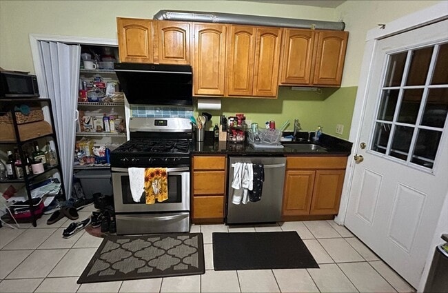
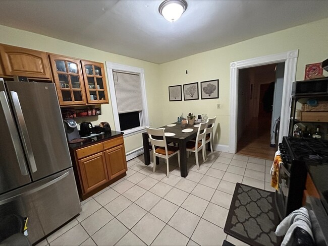
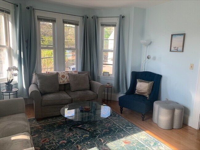
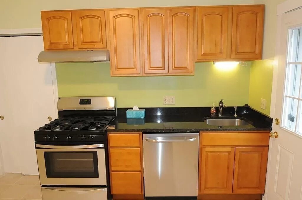
332 Elliot St Unit 2 Photos
What Are Walk Score®, Transit Score®, and Bike Score® Ratings?
Walk Score® measures the walkability of any address. Transit Score® measures access to public transit. Bike Score® measures the bikeability of any address.
What is a Sound Score Rating?
A Sound Score Rating aggregates noise caused by vehicle traffic, airplane traffic and local sources
332 Elliot St
Newton, MA 02464