$2,600
/ Month
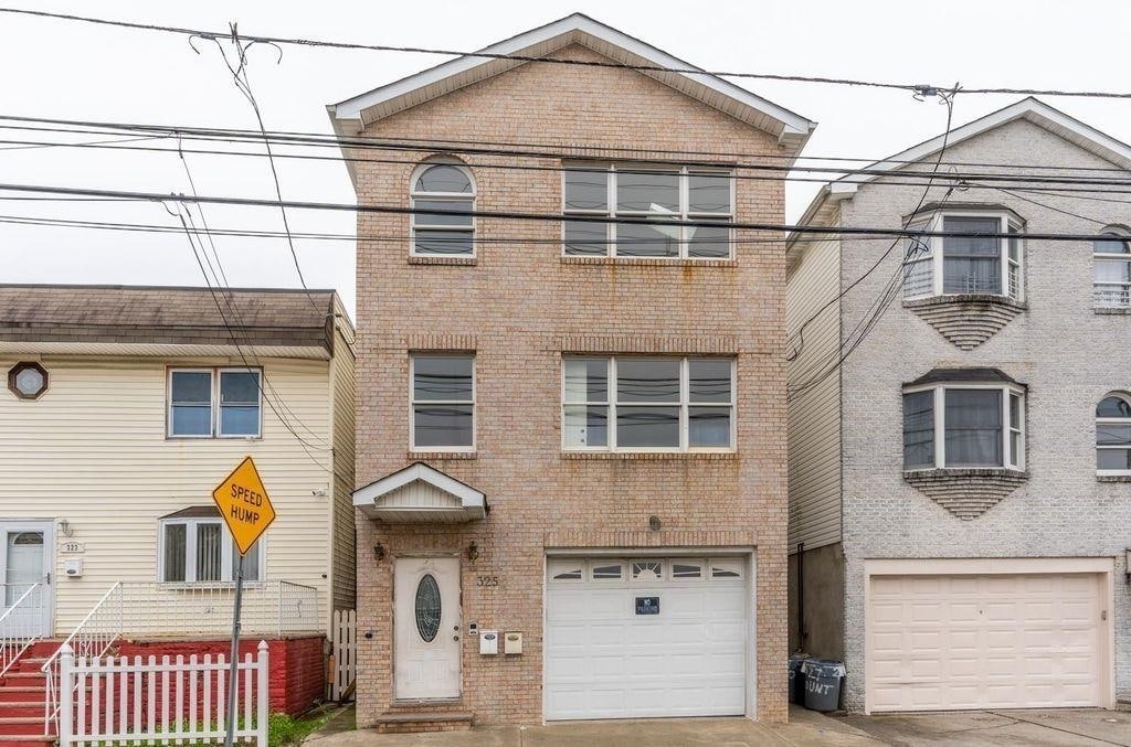
325 Claremont Ave Unit 1
Jersey City, NJ 07305
Today
|
Edit
Favorites
646-685-1228
-
Bedrooms
3
-
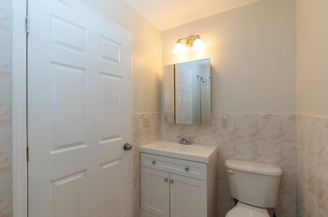
Bathrooms
2
-
Square Feet
1,000 sq ft
-
Available
Available Dec 6
Highlight
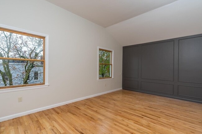
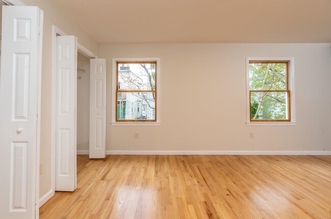
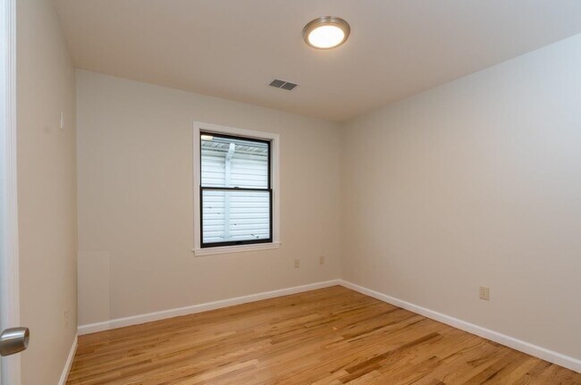
- Hardwood Floors
325 Claremont Ave Unit 1

Favorites
About This Home
Available Dec 6
WELCOME TO YOUR NEXT JERSEY CITY HEIGHTS 3 BED 2 BATH RENTAL OPPORTUNITY !! This amazingly located apartment has exactly what you have been seeking for! This 1st fl unit welcomes you with a living room / dining room, a beautiful kitchen with 3 spacious bedrooms, 2 full bathrooms and an additional 1 half bathroom. You get the benefit of being within blocks of major NY/NYC transportation, shopping, banks, restaurants, and so much more! Schedule a private tour today to see your next available Jersey City apt!
325 Claremont Ave is an apartment community located in Hudson County and the 07305 ZIP Code.
* Price shown is base rent. Excludes user-selected optional fees and variable or usage-based fees and required charges due at or prior to move-in or at move-out. Price, availability, fees, and any applicable rent special are subject to change without notice.
* Square footage definitions vary. Displayed square footage is approximate.
Features
- Oven
- Hardwood Floors
Contact
- Listed by ITALO FLORES | ACCESS HOMES REALTY
- Phone Number
- Contact
-
Source
Hudson County Multiple Listing Service
Copyright © 2025 Hudson County Multiple Listing Service. All rights reserved. All information provided by the listing agent/broker is deemed reliable but is not guaranteed and should be independently verified.
Location
Get Directions
Amenities
- Oven
- Hardwood Floors
The Bergen-Lafayette community, lying just southwest of the downtown area in Jersey City, represents many separate neighborhoods, including the Communipaw Junction and the Bergen Section. The residents of the community benefit from a close proximity not only with various other neighborhoods and cultural atmospheres, but also with the Liberty State Park, Science Center, and Liberty National Golf Course.. Bergen-Lafayette sits just 1.5 miles from the heart of the city.
Learn more about living in Bergen-Lafayette
Education
| Colleges & Universities | Distance | ||
|---|---|---|---|
| Colleges & Universities | Distance | ||
| Walk: | 8 min | 0.4 mi | |
| Drive: | 3 min | 1.5 mi | |
| Drive: | 5 min | 2.1 mi | |
| Drive: | 17 min | 7.0 mi |
325 Claremont Ave Unit 1 is within 8 minutes or 0.4 mile from New Jersey City University. It is also near Saint Peter's College and Hudson Co. Comm. College.
Transportation options available in Jersey City include West Side Avenue, located 0.3 mile from 325 Claremont Ave Unit 1. 325 Claremont Ave Unit 1 is near Newark Liberty International, located 8.3 miles or 13 minutes away, and LaGuardia, located 15.8 miles or 35 minutes away.
| Transit / Subway | Distance | ||
|---|---|---|---|
| Transit / Subway | Distance | ||
|
|
Walk: | 5 min | 0.3 mi |
|
|
Walk: | 12 min | 0.7 mi |
|
|
Drive: | 4 min | 1.1 mi |
|
|
Drive: | 4 min | 1.5 mi |
|
|
Drive: | 4 min | 1.8 mi |
| Commuter Rail | Distance | ||
|---|---|---|---|
| Commuter Rail | Distance | ||
|
|
Drive: | 5 min | 2.1 mi |
|
|
Drive: | 7 min | 3.1 mi |
|
|
Drive: | 8 min | 3.6 mi |
|
|
Drive: | 10 min | 3.9 mi |
|
|
Drive: | 15 min | 7.5 mi |
| Airports | Distance | ||
|---|---|---|---|
| Airports | Distance | ||
|
Newark Liberty International
|
Drive: | 13 min | 8.3 mi |
|
LaGuardia
|
Drive: | 35 min | 15.8 mi |
Time and distance from 325 Claremont Ave Unit 1.
| Shopping Centers | Distance | ||
|---|---|---|---|
| Shopping Centers | Distance | ||
| Walk: | 12 min | 0.7 mi | |
| Drive: | 4 min | 1.2 mi | |
| Drive: | 4 min | 1.6 mi |
325 Claremont Ave Unit 1 has 3 shopping centers within 1.6 miles, which is about a 4-minute walk. The miles and minutes will be for the farthest away property.
| Parks and Recreation | Distance | ||
|---|---|---|---|
| Parks and Recreation | Distance | ||
|
Liberty Science Center
|
Drive: | 6 min | 2.6 mi |
|
Stephen Gregg Park
|
Drive: | 7 min | 2.9 mi |
|
Liberty Landing Marina
|
Drive: | 8 min | 3.0 mi |
|
Ellis Island National Monument
|
Drive: | 13 min | 4.0 mi |
|
Statue of Liberty
|
Drive: | 13 min | 4.0 mi |
325 Claremont Ave Unit 1 has 5 parks within 4.0 miles, including Liberty Science Center, Stephen Gregg Park, and Liberty Landing Marina.
| Hospitals | Distance | ||
|---|---|---|---|
| Hospitals | Distance | ||
| Drive: | 5 min | 2.3 mi | |
| Drive: | 7 min | 3.1 mi | |
| Drive: | 9 min | 4.3 mi |
325 Claremont Ave Unit 1 has 3 hospitals within 4.3 miles, the nearest is Jersey City Medical Center which is 2.3 miles away and a 5 minute drive.
| Military Bases | Distance | ||
|---|---|---|---|
| Military Bases | Distance | ||
| Drive: | 10 min | 4.4 mi | |
| Drive: | 18 min | 8.0 mi | |
| Drive: | 28 min | 12.7 mi |
325 Claremont Ave Unit 1 has 3 military bases within 12.7 miles, the nearest is Military Ocean Terminal which is 4.4 miles away and a 10 minute drive.
You May Also Like
How do I access Social Services in New Jersey?
Statewide service is free, confidential, multilingual and always open. Three easy ways to reach Social Services in NJ: Dial 2-1-1; text your zip code to 898-211; or chat at https://www.nj211.org
Similar Rentals Nearby
-
-
-
-
1 / 22

-
-
-
-
-
-


What Are Walk Score®, Transit Score®, and Bike Score® Ratings?
Walk Score® measures the walkability of any address. Transit Score® measures access to public transit. Bike Score® measures the bikeability of any address.
What is a Sound Score Rating?
A Sound Score Rating aggregates noise caused by vehicle traffic, airplane traffic and local sources

325 Claremont Ave
Jersey City, NJ 07305