

$2,000
Total Monthly Price
32 Sidlaw Rd Unit 6
Boston, MA 02135
Today
|
Edit
Favorites
857-265-6382
-
Bedrooms
Studio
-
Bathrooms
1
-
Square Feet
346 sq ft
-
Available
Available Now
Highlights
- Medical Services
- Property is near public transit and schools
- Jogging Path
- No Cooling
- Park
- Shops
32 Sidlaw Rd Unit 6

Favorites
About This Home
$2,000 deposit,
Available Now
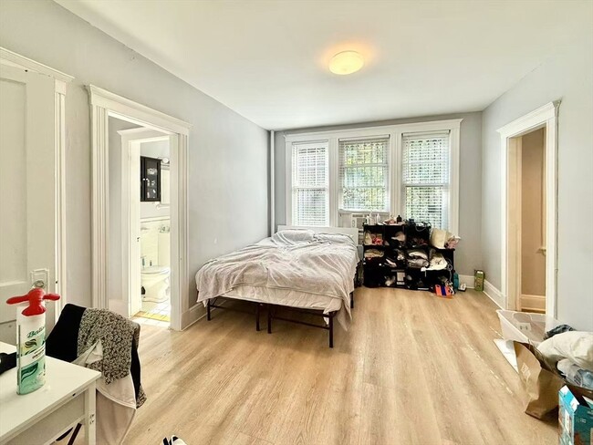
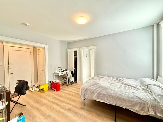
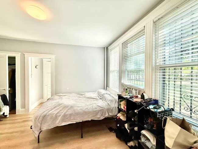
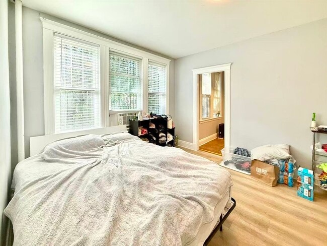
This well-located studio sits just steps to public transportation,the B Green Line,parks,shops,and dining—ideal for commuters. Second-floor unit overlooks a quiet rear garden and offers a bright,airy layout. Features include an entry foyer with large coat closet,open living space accommodating a queen bed,living area,and home office,plus an additional closet. High ceilings,updated floors,newer windows,and great natural light throughout. Full bath with window and linen closet. Spacious eat-in kitchen. Pet-friendly association with low condo fees. MLS# 73482645
32 Sidlaw Rd is a condo located in Suffolk County and the 02135 ZIP Code.
* Price shown is total price based on community-supplied monthly required fees. Excludes user-selected optional fees and variable or usage-based fees and required charges due at or prior to move-in or at move-out. Price, availability, fees, and any applicable rent special are subject to change without notice.
* Square footage definitions vary. Displayed square footage is approximate.
Home Details
Home Type
Condominium
Year Built
Built in 1925
Bedrooms and Bathrooms
1 Full Bathroom
Home Design
Entry on the 2nd floor
Interior Spaces
1-Story Property
346 Sq Ft Home
Kitchen
Range
Oven
Freezer
Microwave
Disposal
Listing and Financial Details
Security Deposit $2,000
Property Available on 6/1/26
12 Month Lease Term
Assessor Parcel Number 1212322
Rent includes heat, hot water, water, sewer, trash collection, snow removal, extra storage, laundry facilities
Location
Property is near public transit and schools
Utilities
No Cooling
Heating System Uses Natural Gas
Community Details
Amenities
Medical Services
Shops
Laundry Facilities
Overview
No Home Owners Association
Pet Policy
No Pets Allowed
Recreation
Jogging Path
Park
Fees and Policies
The fees listed below are community-provided and may exclude utilities or add-ons. All payments are made directly to the property and are non-refundable unless otherwise specified. Use the Cost Calculator to determine costs based on your needs.
-
One-Time Basics
-
Due at Move-In
-
Security Deposit - RefundableCharged per unit.$2,000
-
-
Due at Move-In
Property Fee Disclaimer: Based on community-supplied data and independent market research. Subject to change without notice. May exclude fees for mandatory or optional services and usage-based utilities.
Contact
- Listed by Yuwei Liao | Hooli Homes Boston
- Phone Number
-
Source
 MLS Property Information Network
The property listing data and information set forth herein were provided to MLS Property Information Network, Inc. from third party sources, including sellers, lessors and public records, and were compiled by MLS Property Information Network, Inc. The property listing data and information are for the personal, non-commercial use of consumers having a good faith interest in purchasing or leasing listed properties of the type displayed to them and may not be used for any purpose other than to identify prospective properties which such consumers may have a good faith interest in purchasing or leasing. MLS Property Information Network, Inc. and its subscribers disclaim any and all representations and warranties as to the accuracy of the property listing data and information set forth herein. All properties are subject to prior sale, change or withdrawal. Copyright © 2026 MLS Property Information Network, Inc. All rights reserved.
Location
Get Directions
Saint Elizabeth’s is a Brighton neighborhood situated about 10 miles away from Boston. Thanks to Saint Elizabeth’s top border sitting on Highway 20, commuting in and out of Brighton is easy. Some residents travel by car, but buses and railways make commuting via public transportation a breeze.
The neighborhood’s best amenities are two world-renowned hospitals, Saint Elizabeth’s Medical Center and Franciscan Children’s, that sit on the edge of town. Other great amenities of Saint Elizabeth’s include many local parks like Ringer Playground and Chestnut Hill Reservoir, which has great trails and greenspace. This neighborhood is also equipped with cozy coffee shops, restaurants serving international and American classics, and shopping plazas with grocers and convenience stores.
Saint Elizabeth’s has several rental options ranging from apartments to single-family homes.
Learn more about living in St Elizabeth's
Amenities
- Disposal
- Microwave
- Range
- Refrigerator
- Freezer
Education
| Colleges & Universities | Distance | ||
|---|---|---|---|
| Colleges & Universities | Distance | ||
| Walk: | 15 min | 0.8 mi | |
| Drive: | 2 min | 1.1 mi | |
| Drive: | 5 min | 2.8 mi | |
| Drive: | 7 min | 3.4 mi |
32 Sidlaw Rd Unit 6 is within 15 minutes or 0.8 mile from Boston College, Brighton. It is also near Boston College and Boston University.
Transportation options available in Boston include Chiswick Road Station, located 0.1 mile from 32 Sidlaw Rd Unit 6. 32 Sidlaw Rd Unit 6 is near General Edward Lawrence Logan International, located 9.9 miles or 18 minutes away.
| Transit / Subway | Distance | ||
|---|---|---|---|
| Transit / Subway | Distance | ||
|
|
Walk: | 2 min | 0.1 mi |
|
|
Walk: | 3 min | 0.2 mi |
|
|
Walk: | 6 min | 0.4 mi |
|
|
Walk: | 7 min | 0.4 mi |
|
|
Walk: | 9 min | 0.5 mi |
| Commuter Rail | Distance | ||
|---|---|---|---|
| Commuter Rail | Distance | ||
|
|
Drive: | 9 min | 3.9 mi |
|
|
Drive: | 7 min | 4.1 mi |
|
|
Drive: | 8 min | 4.2 mi |
| Drive: | 10 min | 4.8 mi | |
|
|
Drive: | 9 min | 4.8 mi |
| Airports | Distance | ||
|---|---|---|---|
| Airports | Distance | ||
|
General Edward Lawrence Logan International
|
Drive: | 18 min | 9.9 mi |
Time and distance from 32 Sidlaw Rd Unit 6.
| Shopping Centers | Distance | ||
|---|---|---|---|
| Shopping Centers | Distance | ||
| Walk: | 14 min | 0.7 mi | |
| Drive: | 2 min | 1.2 mi | |
| Drive: | 5 min | 2.0 mi |
32 Sidlaw Rd Unit 6 has 3 shopping centers within 2.0 miles, which is about a 5-minute drive. The miles and minutes will be for the farthest away property.
| Parks and Recreation | Distance | ||
|---|---|---|---|
| Parks and Recreation | Distance | ||
|
Chestnut Hill Reservation
|
Walk: | 7 min | 0.4 mi |
|
Frederick Law Olmsted National Historic Site
|
Drive: | 4 min | 2.0 mi |
|
Hammond Pond Reservation
|
Drive: | 4 min | 2.2 mi |
|
John Fitzgerald Kennedy National Historic Site
|
Drive: | 4 min | 2.2 mi |
|
Coit Observatory
|
Drive: | 6 min | 3.3 mi |
32 Sidlaw Rd Unit 6 has 5 parks within 3.3 miles, including Chestnut Hill Reservation, John Fitzgerald Kennedy National Historic Site, and Frederick Law Olmsted National Historic Site.
| Hospitals | Distance | ||
|---|---|---|---|
| Hospitals | Distance | ||
| Drive: | 3 min | 1.4 mi | |
| Drive: | 3 min | 1.6 mi | |
| Drive: | 4 min | 2.3 mi |
32 Sidlaw Rd Unit 6 has 3 hospitals within 2.3 miles, the nearest is Franciscan Children's Hospital & Rehab Center which is 1.4 miles away and a 3 minute drive.
| Military Bases | Distance | ||
|---|---|---|---|
| Military Bases | Distance | ||
| Drive: | 22 min | 12.9 mi | |
| Drive: | 27 min | 15.6 mi |
32 Sidlaw Rd Unit 6 is 12.9 miles from US Military Reservation, and is convenient to other military bases, including Hanscom Air Force Base.
You May Also Like
Similar Rentals Nearby


What Are Walk Score®, Transit Score®, and Bike Score® Ratings?
Walk Score® measures the walkability of any address. Transit Score® measures access to public transit. Bike Score® measures the bikeability of any address.
What is a Sound Score Rating?
A Sound Score Rating aggregates noise caused by vehicle traffic, airplane traffic and local sources.

32 Sidlaw Rd
Boston, MA 02135