
$1,700 / Month
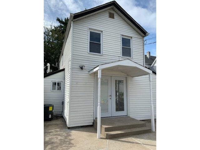
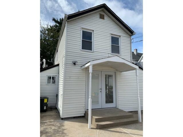
31 Devon St Unit REAR HOU
Kearny, NJ 07032
2 Weeks Ago
Favorites
31 Devon St Unit REAR HOU

Favorites
Check Back Soon for Upcoming Availability
| Beds | Baths | Average SF |
|---|---|---|
| 2 Bedrooms 2 Bedrooms 2 Br | 1 Bath 1 Bath 1 Ba | — |
About This Property
Welcome to this single family home for rent. This home has not only privacy but renovations through out. 1st Floor has living room, Modern Eat in kitchen, Full modern bath. Large closet with washer & dryer hook ups. 2 Bedrooms with hardwood floors. This home also has central air and forced hot air. Close to Transportation, schools & shopping. No Pets (Listing 6917170 Confirmed 9/19/2019.)
31 Devon St is an apartment community located in Hudson County and the 07032 ZIP Code.
Location
Get Directions
Sitting adjacent to Newark and Jersey City, Kearny is just minutes from Manhattan, giving residents easy access to New York City for work or leisure (either via car or PATH rail service). While most of the town’s area is industrial, the residential area on the northwest side of town is an attractive mix of neighborhoods and storefronts. Kearny Avenue serves as the main drag through town, featuring a wide selection of locally-owned restaurants, shops, and bars. West Hudson Park provides a large open area for outdoor recreation, including a network of trails for running and biking.
Learn more about living in Kearny
Education
| Colleges & Universities | Distance | ||
|---|---|---|---|
| Colleges & Universities | Distance | ||
| Drive: | 4 min | 1.6 mi | |
| Drive: | 5 min | 2.1 mi | |
| Drive: | 6 min | 2.2 mi | |
| Drive: | 10 min | 4.8 mi |
31 Devon St Unit REAR HOU is within 4 minutes or 1.6 miles from Rutgers, Newark Campus. It is also near N.J. Inst. of Technology and Essex County College.
Transportation options available in Kearny include Atlantic Street, located 1.3 miles from 31 Devon St Unit REAR HOU. 31 Devon St Unit REAR HOU is near Newark Liberty International, located 7.9 miles or 11 minutes away, and LaGuardia, located 25.9 miles or 40 minutes away.
| Transit / Subway | Distance | ||
|---|---|---|---|
| Transit / Subway | Distance | ||
|
|
Drive: | 4 min | 1.3 mi |
|
|
Drive: | 4 min | 1.4 mi |
|
|
Drive: | 4 min | 1.4 mi |
|
|
Drive: | 4 min | 1.6 mi |
|
|
Drive: | 5 min | 2.5 mi |
| Commuter Rail | Distance | ||
|---|---|---|---|
| Commuter Rail | Distance | ||
|
|
Drive: | 2 min | 1.1 mi |
|
|
Drive: | 5 min | 2.1 mi |
|
|
Drive: | 5 min | 2.5 mi |
|
|
Drive: | 7 min | 3.8 mi |
|
|
Drive: | 9 min | 4.0 mi |
| Airports | Distance | ||
|---|---|---|---|
| Airports | Distance | ||
|
Newark Liberty International
|
Drive: | 11 min | 7.9 mi |
|
LaGuardia
|
Drive: | 40 min | 25.9 mi |
Time and distance from 31 Devon St Unit REAR HOU.
| Shopping Centers | Distance | ||
|---|---|---|---|
| Shopping Centers | Distance | ||
| Walk: | 13 min | 0.7 mi | |
| Walk: | 18 min | 1.0 mi | |
| Walk: | 18 min | 1.0 mi |
31 Devon St Unit REAR HOU has 3 shopping centers within 1.0 mile, which is about a 18-minute walk. The miles and minutes will be for the farthest away property.
| Parks and Recreation | Distance | ||
|---|---|---|---|
| Parks and Recreation | Distance | ||
|
Newark Museum and Dreyfuss Planetarium
|
Drive: | 5 min | 1.7 mi |
|
Kearny Marsh
|
Drive: | 5 min | 1.7 mi |
|
Branch Brook Park
|
Drive: | 7 min | 2.7 mi |
|
Richard W. DeKorte Park
|
Drive: | 10 min | 3.6 mi |
|
McDowell Observatory
|
Drive: | 18 min | 6.8 mi |
31 Devon St Unit REAR HOU has 5 parks within 6.8 miles, including Newark Museum and Dreyfuss Planetarium, Kearny Marsh, and Branch Brook Park.
| Hospitals | Distance | ||
|---|---|---|---|
| Hospitals | Distance | ||
| Drive: | 4 min | 1.7 mi | |
| Drive: | 6 min | 3.1 mi | |
| Drive: | 8 min | 4.0 mi |
31 Devon St Unit REAR HOU has 3 hospitals within 4.0 miles, the nearest is Saint Michael's Medical Center which is 1.7 miles away and a 4 minute drive.
| Military Bases | Distance | ||
|---|---|---|---|
| Military Bases | Distance | ||
| Drive: | 18 min | 9.5 mi | |
| Drive: | 25 min | 11.4 mi | |
| Drive: | 34 min | 19.0 mi |
31 Devon St Unit REAR HOU has 3 military bases within 19.0 miles, the nearest is Military Ocean Terminal which is 9.5 miles away and a 18 minute drive.
You May Also Like
Similar Rentals Nearby


What Are Walk Score®, Transit Score®, and Bike Score® Ratings?
Walk Score® measures the walkability of any address. Transit Score® measures access to public transit. Bike Score® measures the bikeability of any address.
What is a Sound Score Rating?
A Sound Score Rating aggregates noise caused by vehicle traffic, airplane traffic and local sources
31 Devon St
Kearny, NJ 07032