$1,700 / Month
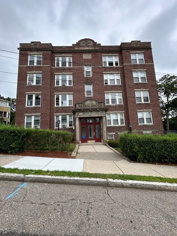
31 Dennison Ave Unit 10
Framingham, MA 01702
2 Weeks Ago
Favorites
31 Dennison Ave Unit 10

Favorites
Check Back Soon for Upcoming Availability
| Beds | Baths | Average SF |
|---|---|---|
| 1 Bedroom 1 Bedroom 1 Br | 1 Bath 1 Bath 1 Ba | 800 SF |
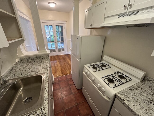
About This Property
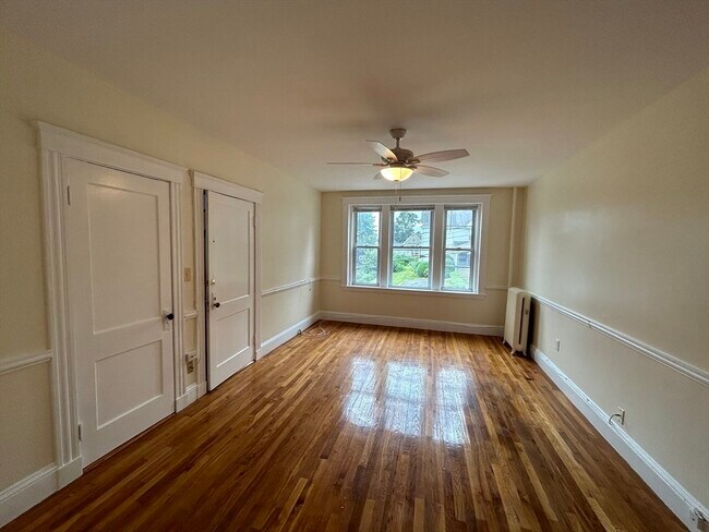
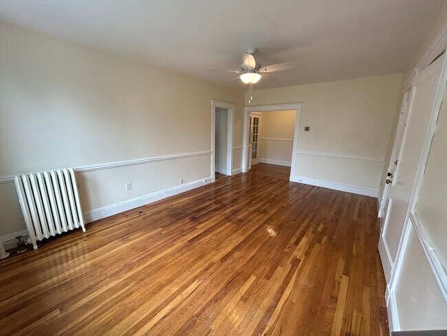
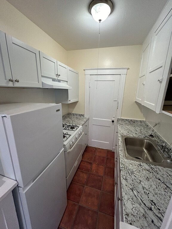
Clean and updated one bedroom rental in Framingham! This great unit has hardwoods throughout and lots of windows for plenty of natural sunlight. There are ceiling fans in both rooms and the whole unit was just recently painted. Heat and hot water is included in the rent. Tenant is responsible for gas cooking and electricity. All applicants are subject to a credit/background check and references. No dogs but cats would be considered. There is one car off-street parking available and coin op laundry in the basement for residents.
31 Dennison Ave is an apartment community located in Middlesex County and the 01702 ZIP Code.
Location
Get Directions
Just west of Boston and East of Worcester sits Metro West, a region that houses a group of towns and cities with significant historical backgrounds. A total of 19 municipalities make up the core of this community, but other municipalities are considered to be a part of the Interstate 495/Metro West Corridor.
Learn more about living in Metro WestBelow are rent ranges for similar nearby apartments
| Beds | Average Size | Lowest | Typical | Premium |
|---|---|---|---|---|
| Studio Studio Studio | 505-507 Sq Ft | $1,400 | $2,196 | $3,460 |
| 1 Bed 1 Bed 1 Bed | 865-866 Sq Ft | $1,500 | $2,863 | $9,937 |
| 2 Beds 2 Beds 2 Beds | 1242-1243 Sq Ft | $1,750 | $3,612 | $16,632 |
| 3 Beds 3 Beds 3 Beds | 1532-1535 Sq Ft | $1,000 | $4,663 | $21,719 |
| 4 Beds 4 Beds 4 Beds | 3626 Sq Ft | $1,210 | $6,777 | $30,000 |
Education
| Colleges & Universities | Distance | ||
|---|---|---|---|
| Colleges & Universities | Distance | ||
| Drive: | 6 min | 2.3 mi | |
| Drive: | 16 min | 6.7 mi | |
| Drive: | 17 min | 9.1 mi | |
| Drive: | 22 min | 12.3 mi |
31 Dennison Ave Unit 10 is within 6 minutes or 2.3 miles from Framingham State College. It is also near Wellesley College and Babson College.
Transportation options available in Framingham include Woodland Station, located 10.5 miles from 31 Dennison Ave Unit 10. 31 Dennison Ave Unit 10 is near General Edward Lawrence Logan International, located 24.4 miles or 37 minutes away, and Worcester Regional, located 26.2 miles or 46 minutes away.
| Transit / Subway | Distance | ||
|---|---|---|---|
| Transit / Subway | Distance | ||
|
|
Drive: | 18 min | 10.5 mi |
|
|
Drive: | 20 min | 11.1 mi |
|
|
Drive: | 19 min | 11.3 mi |
| Commuter Rail | Distance | ||
|---|---|---|---|
| Commuter Rail | Distance | ||
|
|
Walk: | 16 min | 0.9 mi |
|
|
Walk: | 18 min | 1.0 mi |
|
|
Drive: | 5 min | 1.7 mi |
|
|
Drive: | 9 min | 4.2 mi |
|
|
Drive: | 16 min | 5.2 mi |
| Airports | Distance | ||
|---|---|---|---|
| Airports | Distance | ||
|
General Edward Lawrence Logan International
|
Drive: | 37 min | 24.4 mi |
|
Worcester Regional
|
Drive: | 46 min | 26.2 mi |
Time and distance from 31 Dennison Ave Unit 10.
| Shopping Centers | Distance | ||
|---|---|---|---|
| Shopping Centers | Distance | ||
| Walk: | 10 min | 0.6 mi | |
| Walk: | 18 min | 0.9 mi | |
| Drive: | 4 min | 1.5 mi |
31 Dennison Ave Unit 10 has 3 shopping centers within 1.5 miles, which is about a 4-minute walk. The miles and minutes will be for the farthest away property.
| Parks and Recreation | Distance | ||
|---|---|---|---|
| Parks and Recreation | Distance | ||
|
Callahan State Park
|
Drive: | 9 min | 4.4 mi |
|
Cowassock Woods and Ashland Town Forest
|
Drive: | 10 min | 4.5 mi |
|
Hop Brook Natural Area
|
Drive: | 9 min | 4.6 mi |
|
Garden in the Woods
|
Drive: | 12 min | 5.7 mi |
|
Cochituate State Park
|
Drive: | 18 min | 10.8 mi |
31 Dennison Ave Unit 10 has 5 parks within 10.8 miles, including Cochituate State Park, Callahan State Park, and Cowassock Woods and Ashland Town Forest.
| Hospitals | Distance | ||
|---|---|---|---|
| Hospitals | Distance | ||
| Walk: | 11 min | 0.6 mi | |
| Drive: | 17 min | 10.2 mi | |
| Drive: | 19 min | 11.0 mi |
31 Dennison Ave Unit 10 has 3 hospitals within 11.0 miles, the nearest is MetroWest Medical Center which is 0.6 mile away and a 11 minute walk.
| Military Bases | Distance | ||
|---|---|---|---|
| Military Bases | Distance | ||
| Drive: | 9 min | 4.5 mi | |
| Drive: | 33 min | 16.9 mi |
31 Dennison Ave Unit 10 is 4.5 miles from US Military Reservation, and is convenient to other military bases, including Hanscom Air Force Base.
You May Also Like
Similar Rentals Nearby


What Are Walk Score®, Transit Score®, and Bike Score® Ratings?
Walk Score® measures the walkability of any address. Transit Score® measures access to public transit. Bike Score® measures the bikeability of any address.
What is a Sound Score Rating?
A Sound Score Rating aggregates noise caused by vehicle traffic, airplane traffic and local sources
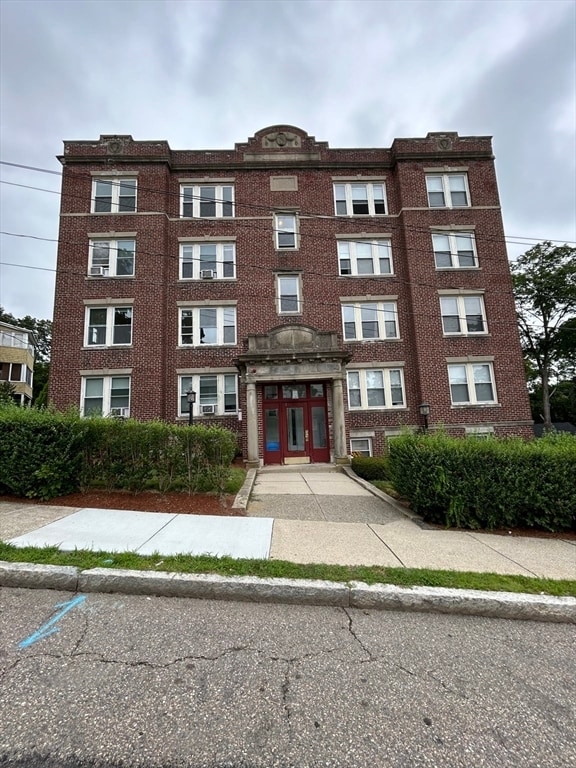
31 Dennison Ave
Framingham, MA 01702