
Albion Oak Park
1000 Lake St,
Oak Park, IL 60301
$1,770 - $5,135 Total Monthly Price
Studio - 3 Beds

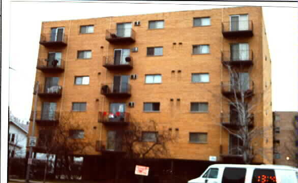
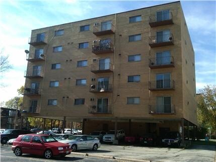

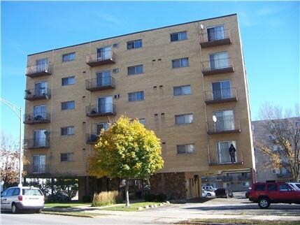
At 300 Des Plaines Ave in Forest Park, find your new home. These apartments are located on Des Plaines Ave in the 60130 area of Forest Park. From amenities to floorplan options, the professional leasing staff is excited to help you find your new home. Be sure to check out the current floorplan options. Drop by to talk about your next apartment.
300 Des Plaines Ave is an apartment community located in Cook County and the 60130 ZIP Code. This area is served by the Forest Park School District 91 attendance zone.
High Speed Internet Access
Refrigerator
Smoke Free
Heating
West Cook is a multicultural neighborhood south of O’Hare International Airport. Golfers in the community enjoy its numerous golf greens, including Oak Park Country Club and Edgewood Valley Country Club.
Public transit abounds in West Cook, attracting renters who wish to live outside the cities in which they work. Residents appreciate the shopping opportunities at Fashion Outlets of Chicago and North Riverside Park Mall.
The Brookfield Zoo is a fun-filled attraction in West Cook which houses hundreds of animals. Locals adore the neighborhood’s lush green spaces – many of which are in walking distance of affordable West Cook apartments. Direct access to Interstate 55 and Interstate 294 makes commuting easy, whether you’re traveling into Chicago or a neighboring state.
Learn more about living in West CookCompare neighborhood and city base rent averages by bedroom.
| West Cook | Forest Park, IL | |
|---|---|---|
| Studio | $902 | $971 |
| 1 Bedroom | $1,120 | $1,231 |
| 2 Bedrooms | $1,387 | $1,663 |
| 3 Bedrooms | $1,520 | $1,269 |
| Colleges & Universities | Distance | ||
|---|---|---|---|
| Colleges & Universities | Distance | ||
| Drive: | 6 min | 2.0 mi | |
| Drive: | 5 min | 2.0 mi | |
| Drive: | 6 min | 2.1 mi | |
| Drive: | 10 min | 4.5 mi |


Transportation options available in Forest Park include Harlem/Lake Station (Green Line), located 0.7 mile from 300 Des Plaines Ave. 300 Des Plaines Ave is near Chicago Midway International, located 10.0 miles or 17 minutes away, and Chicago O'Hare International, located 11.9 miles or 23 minutes away.
| Transit / Subway | Distance | ||
|---|---|---|---|
| Transit / Subway | Distance | ||
|
|
Walk: | 14 min | 0.7 mi |
|
|
Drive: | 3 min | 1.1 mi |
|
|
Drive: | 4 min | 1.6 mi |
|
|
Drive: | 3 min | 1.6 mi |
|
|
Drive: | 7 min | 3.6 mi |
| Commuter Rail | Distance | ||
|---|---|---|---|
| Commuter Rail | Distance | ||
|
|
Walk: | 16 min | 0.9 mi |
|
|
Drive: | 4 min | 1.8 mi |
|
|
Drive: | 5 min | 2.6 mi |
|
|
Drive: | 7 min | 3.5 mi |
|
|
Drive: | 9 min | 3.6 mi |
| Airports | Distance | ||
|---|---|---|---|
| Airports | Distance | ||
|
Chicago Midway International
|
Drive: | 17 min | 10.0 mi |
|
Chicago O'Hare International
|
Drive: | 23 min | 11.9 mi |
Scores provided by
Traffic
ActiveAirport
CalmBusinesses
ActiveScores provided by
HowLoud What is a Sound Score Rating? A Sound Score Rating aggregates noise caused by vehicle traffic, airplane traffic and local sources. How It WorksTime and distance from 300 Des Plaines Ave.
| Shopping Centers | Distance | ||
|---|---|---|---|
| Shopping Centers | Distance | ||
| Walk: | 1 min | 0.1 mi | |
| Walk: | 7 min | 0.4 mi | |
| Walk: | 11 min | 0.6 mi |
| Parks and Recreation | Distance | ||
|---|---|---|---|
| Parks and Recreation | Distance | ||
|
Tyrell Trailside Museum / Thatcher Woods
|
Drive: | 5 min | 1.7 mi |
|
Oak Park Conservatory
|
Drive: | 4 min | 1.8 mi |
|
Austin Town Hall Park
|
Drive: | 6 min | 3.1 mi |
|
Wonder Works Children's Museum
|
Drive: | 8 min | 3.3 mi |
|
Schuth's Grove / Callahan Grove
|
Drive: | 7 min | 3.6 mi |
| Hospitals | Distance | ||
|---|---|---|---|
| Hospitals | Distance | ||
| Walk: | 11 min | 0.6 mi | |
| Drive: | 4 min | 1.8 mi | |
| Drive: | 5 min | 2.2 mi |
| Military Bases | Distance | ||
|---|---|---|---|
| Military Bases | Distance | ||
| Drive: | 34 min | 24.9 mi |
What Are Walk Score®, Transit Score®, and Bike Score® Ratings?
Walk Score® measures the walkability of any address. Transit Score® measures access to public transit. Bike Score® measures the bikeability of any address.
What is a Sound Score Rating?
A Sound Score Rating aggregates noise caused by vehicle traffic, airplane traffic and local sources.
300 Des Plaines Ave
Forest Park, IL 60130


