

$4,300 / Month
297 Degraw St
Brooklyn, NY 11231
2 Weeks Ago
Favorites
297 Degraw St

Favorites
Check Back Soon for Upcoming Availability
| Beds | Baths | Average SF |
|---|---|---|
| 3 Bedrooms 3 Bedrooms 3 Br | 2 Baths 2 Baths 2 Ba | 839 SF |
About This Property
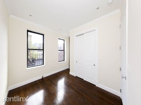
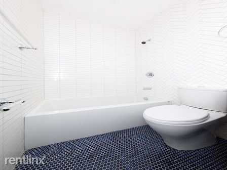
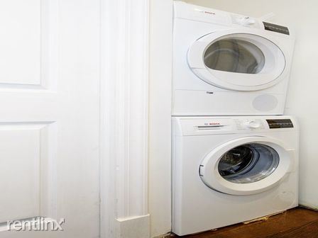
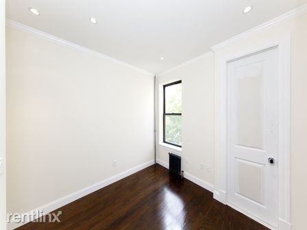
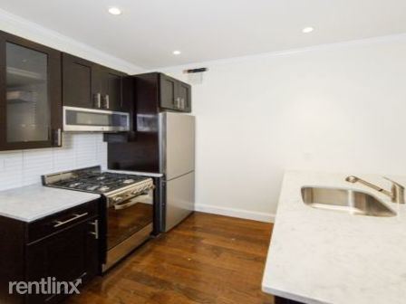
(910) 502-3489 - This is a Brand New Gut Renovated Convertible 3 Bedroom with 2 Full Bathrooms and a Washer And Dryer featuring: Queen Sized Bedrooms, Ebony Hardwood Floors, Recessed Lighting, Carrara Marble Counter-tops, Brand New Stainless Steel Appliances, Espresso cabinets, Crown and Baseboard Moldings, 2 Full Luxury Bathrooms with intricate mosaic tile-work. (RLNE2580031) Other Amenities - Unfurnished. Appliances - Dishwasher, Refrigerator, Range, Washer & Dryer Hookup. Lease lengths - 12 Months. Details regarding this property's Utilities - Resident Pays Electricity, Water Included. Pet policies - Small Dogs Allowed, Cats Allowed.
297 Degraw St is a condo located in Kings County and the 11231 ZIP Code. This area is served by the New York City Geographic District #15 attendance zone.
Location
Get Directions
Located in northwestern Brooklyn, just south of downtown, Boerum Hill offers the serenity of a suburb and the excitement of a bustling urban environment. Residents enjoy access to a host of eclectic restaurants and unique shops strewn along the main commercial thoroughfares—Smith Street and Atlantic Avenue.
In more residential parts of the neighborhood, historic brownstones and townhouses nestle up to quiet, tree-lined streets. Boerum Hill has two sister neighborhoods, Cobble Hill and Carol Gardens, which are both situated west of Boerum Hill. The iconic Barclays Center lies just east of Boerum Hill, hosting exciting events like Brooklyn Nets basketball games, boxing matches, and concerts. Convenient subway access makes getting around from Boerum Hill easy.
Learn more about living in Boerum HillBelow are rent ranges for similar nearby apartments
Education
| Colleges & Universities | Distance | ||
|---|---|---|---|
| Colleges & Universities | Distance | ||
| Walk: | 14 min | 0.7 mi | |
| Walk: | 16 min | 0.8 mi | |
| Drive: | 4 min | 1.1 mi | |
| Drive: | 5 min | 1.3 mi |
297 Degraw St is within 14 minutes or 0.7 mile from Brooklyn Law School. It is also near St. Francis College and ASA College Brooklyn.
Schools


Public Elementary School
Grades PK-5
721 Students
Attendance Zone
Public Middle & High School
Grades 6-12
782 Students
Attendance Zone
Public High School
Grades 9-12
331 Students
Attendance Zone
Private Elementary, Middle & High School
Grades PK-12
1,024 Students
Nearby
Private Elementary & Middle School
Grades PK-8
260 Students
Nearby
Private Elementary & Middle School
Grades K-8
231 Students
Nearby
Private Middle & High School
Grades 6-10
290 Students
Nearby
School data provided by
 The GreatSchools Rating helps parents compare schools within a state based on a variety of school quality indicators and provides a helpful picture of how effectively each school serves all of its students. Ratings are on a scale of 1 (below average) to 10 (above average) and can include test scores, college readiness, academic progress, advanced courses, equity, discipline and attendance data. We also advise parents to visit schools, consider other information on school performance and programs, and consider family needs as part of the school selection process.
View GreatSchools Rating Methodology
Data provided by GreatSchools.org © 2025. All rights reserved.
View GreatSchools Rating Methodology
Data provided by GreatSchools.org © 2025. All rights reserved.
Transportation options available in Brooklyn include Carroll Street, located 0.3 mile from 297 Degraw St. 297 Degraw St is near LaGuardia, located 10.6 miles or 21 minutes away, and Newark Liberty International, located 15.2 miles or 27 minutes away.
| Transit / Subway | Distance | ||
|---|---|---|---|
| Transit / Subway | Distance | ||
|
|
Walk: | 6 min | 0.3 mi |
|
|
Walk: | 7 min | 0.4 mi |
|
|
Walk: | 14 min | 0.8 mi |
|
|
Walk: | 15 min | 0.8 mi |
|
|
Drive: | 4 min | 1.2 mi |
| Commuter Rail | Distance | ||
|---|---|---|---|
| Commuter Rail | Distance | ||
|
|
Drive: | 5 min | 1.6 mi |
|
|
Drive: | 9 min | 3.0 mi |
|
|
Drive: | 12 min | 4.2 mi |
|
|
Drive: | 13 min | 4.4 mi |
|
|
Drive: | 18 min | 7.0 mi |
| Airports | Distance | ||
|---|---|---|---|
| Airports | Distance | ||
|
LaGuardia
|
Drive: | 21 min | 10.6 mi |
|
Newark Liberty International
|
Drive: | 27 min | 15.2 mi |
Time and distance from 297 Degraw St.
| Shopping Centers | Distance | ||
|---|---|---|---|
| Shopping Centers | Distance | ||
| Drive: | 5 min | 1.6 mi | |
| Drive: | 5 min | 1.8 mi | |
| Drive: | 9 min | 3.1 mi |
297 Degraw St has 3 shopping centers within 3.1 miles, which is about a 9-minute drive. The miles and minutes will be for the farthest away property.
| Parks and Recreation | Distance | ||
|---|---|---|---|
| Parks and Recreation | Distance | ||
|
Cobble Hill Park
|
Walk: | 8 min | 0.4 mi |
|
Gowanus Canal
|
Walk: | 13 min | 0.7 mi |
|
Cadman Plaza Park
|
Drive: | 4 min | 1.3 mi |
|
Red Hook Park
|
Drive: | 4 min | 1.5 mi |
|
Coffey Park
|
Drive: | 5 min | 1.6 mi |
297 Degraw St has 5 parks within 1.6 miles, including Cobble Hill Park, Gowanus Canal, and Cadman Plaza Park.
| Hospitals | Distance | ||
|---|---|---|---|
| Hospitals | Distance | ||
| Drive: | 5 min | 1.5 mi | |
| Drive: | 7 min | 2.2 mi | |
| Drive: | 11 min | 3.7 mi |
297 Degraw St has 3 hospitals within 3.7 miles, the nearest is Brooklyn Hospital Center - Downtown Campus which is 1.5 miles away and a 5 minute drive.
| Military Bases | Distance | ||
|---|---|---|---|
| Military Bases | Distance | ||
| Drive: | 11 min | 4.7 mi | |
| Drive: | 25 min | 12.6 mi |
297 Degraw St is 4.7 miles from Governors Island Support Center, and is convenient to other military bases, including Military Ocean Terminal.
You May Also Like
Similar Rentals Nearby


What Are Walk Score®, Transit Score®, and Bike Score® Ratings?
Walk Score® measures the walkability of any address. Transit Score® measures access to public transit. Bike Score® measures the bikeability of any address.
What is a Sound Score Rating?
A Sound Score Rating aggregates noise caused by vehicle traffic, airplane traffic and local sources
297 Degraw St
Brooklyn, NY 11231