
2950 Kling Ave Unit 2
Cincinnati, OH 45211
-
Bedrooms
2
-
Bathrooms
1
-
Square Feet
1,200 sq ft
-
Available
Available Now
Highlights
- Hardwood Floors
- Fenced Lot

About This Home
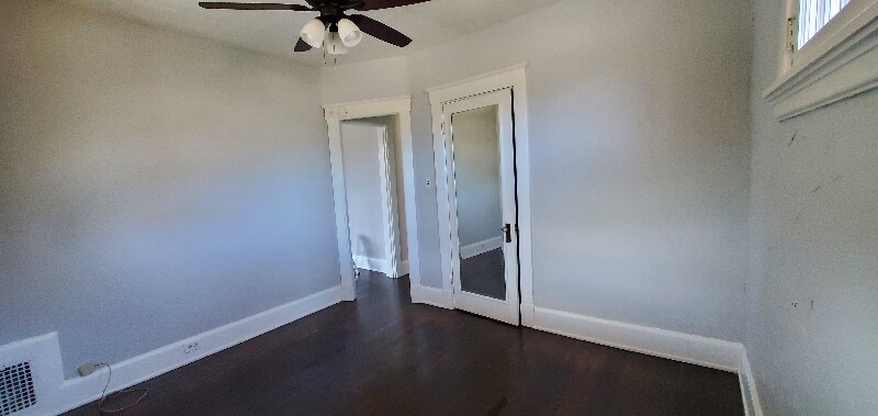
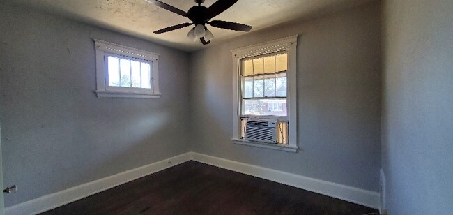
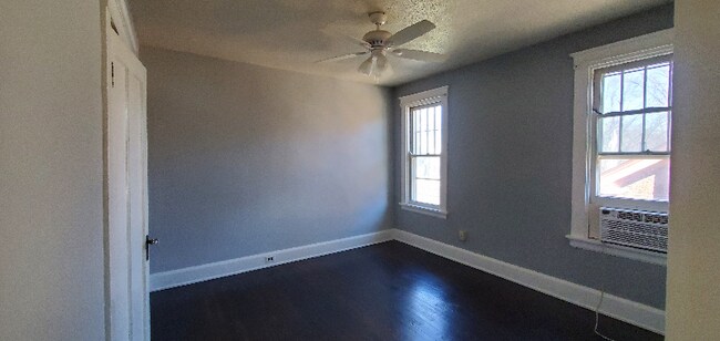
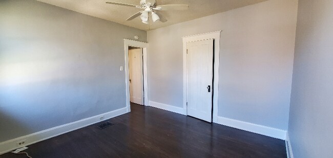
Property Id: 1479520 NON-smoking/incense burning apartment with large outside balcony on second floor of three-family home; hardwood/tile. Window A/C(s) provide cooling and heat is gas/electric. Pocket doors separate living/ dining room (which can be used as a bedroom). The kitchen has a newer French style stainless-steel fridge, stove, pantry, and full-size hutch between kitchen/dining room for dishware. A coin operated washer/ dryer is available; water/refuse pick-up (one refuse/one recycle per unit) is included in rent while gas/electric is tenant's responsibility. One-month security deposit required at lease signing and first month's rent due upon move-in. Pets negotiable: if accepted, there is a $250 non-refundable pet fee and $15 per month, per pet fee. If interested, please text Mrs. Wilson, or Mrs. Junkert, , to arrange a showing; identify the property you're interested in (reference 502) as there are multiple advertised. Maximum occupancy is two individuals per bedroom.
2950 Kling Ave is an apartment community located in Hamilton County and the 45211 ZIP Code.
Features
Hardwood Floors
Refrigerator
Tile Floors
Oven
- Oven
- Refrigerator
- Hardwood Floors
- Tile Floors
- Bicycle Storage
- Fenced Lot
- Lawn
Fees and Policies
The fees below are based on community-supplied data and may exclude additional fees and utilities.
- Dogs Allowed
-
Fees not specified
-
Weight limit--
-
Pet Limit--
Details
Utilities Included
-
Water
-
Trash Removal
-
Sewer
Contact
- Phone Number
- Contact
-
Source

- Oven
- Refrigerator
- Hardwood Floors
- Tile Floors
- Fenced Lot
- Lawn
- Bicycle Storage
Situated about five miles northwest of Downtown Cincinnati, Westwood is the largest neighborhood in the city. Residents flock to Westwood for its many affordable historic homes and modern apartments available for rent in addition to its close proximity to I-74, I-75, and all that Downtown Cincinnati has to offer.
While Westwood is a predominantly residential neighborhood, it is also home to a slew of convenient stores and restaurants. Shopping opportunities abound in Westwood, with plenty of national retailers in Western Hills Plaza and local shops in the growing Town Hall District. Numerous neighborhood parks provide ample space to enjoy the outdoors in town as well as the sprawling 1,400-acre Mount Airy Forest, which is partially located in Westwood.
Learn more about living in Westwood| Colleges & Universities | Distance | ||
|---|---|---|---|
| Colleges & Universities | Distance | ||
| Drive: | 13 min | 5.2 mi | |
| Drive: | 12 min | 5.5 mi | |
| Drive: | 13 min | 5.9 mi | |
| Drive: | 14 min | 6.0 mi |
Transportation options available in Cincinnati include Brewery District Station, Elm & Henry, located 5.2 miles from 2950 Kling Ave Unit 2. 2950 Kling Ave Unit 2 is near Cincinnati/Northern Kentucky International, located 19.5 miles or 37 minutes away.
| Transit / Subway | Distance | ||
|---|---|---|---|
| Transit / Subway | Distance | ||
| Drive: | 12 min | 5.2 mi | |
| Drive: | 12 min | 5.4 mi | |
| Drive: | 13 min | 5.5 mi | |
| Drive: | 13 min | 5.6 mi | |
| Drive: | 13 min | 5.7 mi |
| Commuter Rail | Distance | ||
|---|---|---|---|
| Commuter Rail | Distance | ||
|
|
Drive: | 12 min | 5.5 mi |
| Airports | Distance | ||
|---|---|---|---|
| Airports | Distance | ||
|
Cincinnati/Northern Kentucky International
|
Drive: | 37 min | 19.5 mi |
Time and distance from 2950 Kling Ave Unit 2.
| Shopping Centers | Distance | ||
|---|---|---|---|
| Shopping Centers | Distance | ||
| Drive: | 6 min | 1.7 mi | |
| Drive: | 5 min | 1.9 mi | |
| Drive: | 6 min | 2.1 mi |
| Parks and Recreation | Distance | ||
|---|---|---|---|
| Parks and Recreation | Distance | ||
|
Mt. Airy Forest
|
Drive: | 7 min | 3.3 mi |
|
Buttercup Valley
|
Drive: | 10 min | 4.2 mi |
|
Imago Earth Center
|
Drive: | 12 min | 4.7 mi |
|
Embshoff Woods
|
Drive: | 15 min | 5.2 mi |
|
Wilson Commons
|
Drive: | 13 min | 5.4 mi |
| Hospitals | Distance | ||
|---|---|---|---|
| Hospitals | Distance | ||
| Drive: | 8 min | 3.1 mi | |
| Drive: | 10 min | 4.8 mi | |
| Drive: | 13 min | 6.0 mi |
| Military Bases | Distance | ||
|---|---|---|---|
| Military Bases | Distance | ||
| Drive: | 73 min | 55.0 mi | |
| Drive: | 79 min | 60.0 mi | |
| Drive: | 81 min | 63.3 mi |
2950 Kling Ave Unit 2 Photos
Nearby Apartments
Within 50 Miles of 2950 Kling Ave Cincinnati, OH 45211
-
Vanguard
1001 Marshall Ave
Cincinnati, OH 45219
2-5 Br $749-$1,359 3.7 mi
-
The Farm at Taylor Mill
5142 Old Taylor Mill Rd
Taylor Mill, KY 41015
2 Br $1,410-$1,845 10.3 mi
-
19Nineteen Promenade
1919 Promenade Cir
Union, KY 41091
2-3 Br $1,710-$2,650 13.8 mi
-
Bridgewater Crossing
5 Fall Wood Dr
Hamilton, OH 45011
2 Br $1,605-$1,825 16.3 mi
-
McCauly Crossing
10135 Crossing Dr
Cincinnati, OH 45241
2-3 Br $1,545-$2,545 16.3 mi
-
Union Station
8197 Meeting St
West Chester, OH 45069
2-3 Br $1,549-$1,925 17.4 mi
What Are Walk Score®, Transit Score®, and Bike Score® Ratings?
Walk Score® measures the walkability of any address. Transit Score® measures access to public transit. Bike Score® measures the bikeability of any address.
What is a Sound Score Rating?
A Sound Score Rating aggregates noise caused by vehicle traffic, airplane traffic and local sources

2950 Kling Ave
Cincinnati, OH 45211