
$4,395
/ Month
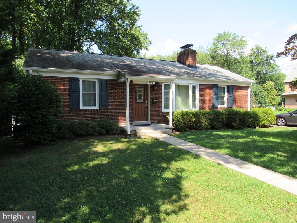
2910 N Westmoreland St
Arlington, VA 22213
Today
Favorites
571-363-6886
-
Bedrooms
4
-
Bathrooms
2
-
Square Feet
2,192 sq ft
-
Available
Available Aug 22
Highlights
- Rambler Architecture
- 2 Fireplaces
- Forced Air Heating and Cooling System
2910 N Westmoreland St

Favorites
About This Home
Available Aug 22
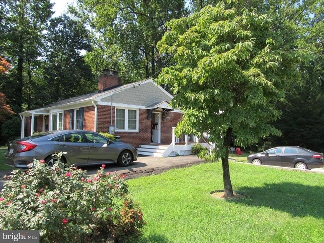
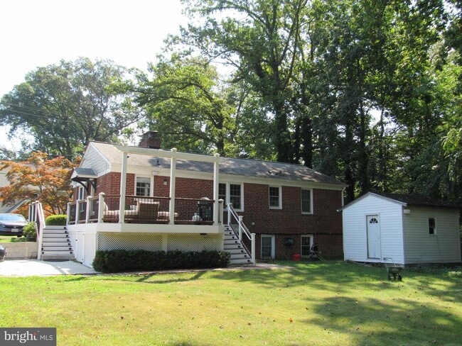
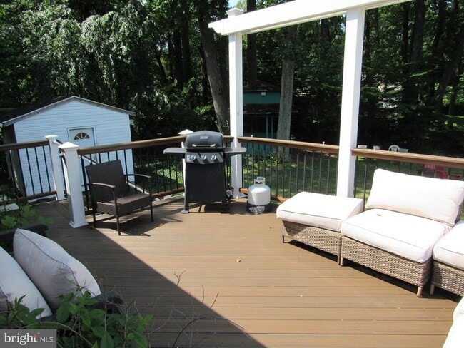
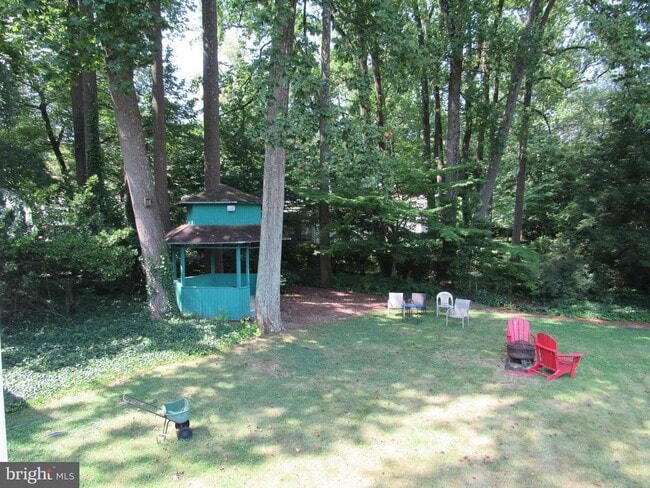
Beautifully Remodeled 2 level brick rambler on .25 acre corner lot in highly sought after neighborhood in N. Arlington, excellent schools, and 1/4 acre landscaped yard complete with a gazebo and year round shade for your entertaining pleasure. Walking distance to East Falls Church Metro. Property is move-in ready featuring plenty of natural lighting, hardwood floors, multiple fireplaces, multiple mounted TV's, and a large bay window. Main level Bath and Kitchen are brand new, never used, to include all new Stainless Steel Appliances. Lower level is a Suite complete with bedroom, full bath and kitchenette area containing full sized fridge, microwave and full sized freezer. Also includes two driveways that can fit 4+ cars as well as plenty of street parking. Don't miss this wonderful opportunity!!
2910 N Westmoreland St is a house located in Arlington County and the 22213 ZIP Code. This area is served by the Arlington County Public Schools attendance zone.
* Price shown is base rent and may not include non-optional fees and utilities. Price, availability, fees, and any applicable rent special are subject to change without notice.
* Square footage definitions vary. Displayed square footage is approximate.
Home Details
Home Type
Single Family Detached Home
Year Built
Built in 1953 | Remodeled in 2025
Bedrooms and Bathrooms
4 Bedrooms | 3 Main Level Bedrooms
2 Full Bathrooms
Finished Basement
Basement Windows
Rear Basement Entry
Home Design
Rambler Architecture
Brick Exterior Construction
Slab Foundation
Interior Spaces
2 Fireplaces
2,192 Sq Ft Home
Property has 2 Levels
Listing and Financial Details
Security Deposit $4,395
12-Month Min and 36-Month Max Lease Term
Available 8/15/25
Assessor Parcel Number 01-011-002
No Smoking Allowed
Residential Lease
Lot Details
10,454 Sq Ft Lot
Property is zoned R-10
Parking
Off-Street Parking
Schools
Yorktown High School
Utilities
Forced Air Heating and Cooling System
Natural Gas Water Heater
Community Details
Overview
No Home Owners Association
Berkshire Oakwood Subdivision, Renovated Rmbler Floorplan
Property Manager
Building Winterized
Pet Policy
No Pets Allowed
Contact
- Listed by John Dennis Burton | Tunell Realty, LLC
- Phone Number
- Contact
-
Source
 Bright MLS, Inc.
Copyright © 2025 Bright MLS, Inc.
Location
Get Directions
Amenities
- Fireplace
- Basement
Situated in the western portion of Arlington, East Falls Church is a picturesque neighborhood brimming with upscale residences in a lush natural environment. Once dominated by dairy farms, East Falls Church offers many small-town comforts along with big-city convenience.
The neighborhood is home to a close-knit community and some of the area’s top-rated schools, many of which are within walking distance. Access to the Metrorail’s Orange and Silver lines places East Falls Church within minutes of the metropolitan delights of the Greater Washington, DC Area.
Several trails run through the neighborhood, providing residents with plenty of options for walking, biking, and enjoying the outdoors. Although East Falls Church is largely residential, numerous commercial conveniences are clustered at the intersection of I-66, Lee Highway, and Washington Boulevard.
Learn more about living in East Falls Church
Education
| Colleges & Universities | Distance | ||
|---|---|---|---|
| Colleges & Universities | Distance | ||
| Drive: | 6 min | 2.7 mi | |
| Drive: | 10 min | 4.5 mi | |
| Drive: | 13 min | 5.6 mi | |
| Drive: | 12 min | 6.0 mi |
2910 N Westmoreland St is within 6 minutes or 2.7 miles from Marymount University. It is also near George Mason Univ., Arlington and NOVA, Alexandira Campus.
Schools


Public Elementary School
Grades PK-5
442 Students
Attendance Zone
Public Middle School
Grades 6-8
827 Students
Attendance Zone
Public High School
Grades 9-12
2,577 Students
Attendance Zone
Private Elementary & Middle School
Grades K-8
419 Students
Nearby
Private Elementary School
Grades PK-K
104 Students
Nearby
Private High School
Grades 9-12
1,193 Students
Nearby
School data provided by
 The GreatSchools Rating helps parents compare schools within a state based on a variety of school quality indicators and provides a helpful picture of how effectively each school serves all of its students. Ratings are on a scale of 1 (below average) to 10 (above average) and can include test scores, college readiness, academic progress, advanced courses, equity, discipline and attendance data. We also advise parents to visit schools, consider other information on school performance and programs, and consider family needs as part of the school selection process.
View GreatSchools Rating Methodology
Data provided by GreatSchools.org © 2025. All rights reserved.
View GreatSchools Rating Methodology
Data provided by GreatSchools.org © 2025. All rights reserved.
Transportation options available in Arlington include Ballston-Mu, located 3.6 miles from 2910 N Westmoreland St. 2910 N Westmoreland St is near Ronald Reagan Washington Ntl, located 11.1 miles or 20 minutes away, and Washington Dulles International, located 19.7 miles or 33 minutes away.
| Transit / Subway | Distance | ||
|---|---|---|---|
| Transit / Subway | Distance | ||
|
|
Drive: | 7 min | 3.6 mi |
|
|
Drive: | 9 min | 5.4 mi |
|
|
Drive: | 10 min | 5.6 mi |
|
|
Drive: | 14 min | 7.9 mi |
|
|
Drive: | 15 min | 9.7 mi |
| Commuter Rail | Distance | ||
|---|---|---|---|
| Commuter Rail | Distance | ||
|
|
Drive: | 20 min | 8.6 mi |
|
|
Drive: | 22 min | 8.9 mi |
|
|
Drive: | 17 min | 9.7 mi |
|
|
Drive: | 17 min | 9.8 mi |
|
|
Drive: | 17 min | 9.8 mi |
| Airports | Distance | ||
|---|---|---|---|
| Airports | Distance | ||
|
Ronald Reagan Washington Ntl
|
Drive: | 20 min | 11.1 mi |
|
Washington Dulles International
|
Drive: | 33 min | 19.7 mi |
Time and distance from 2910 N Westmoreland St.
| Shopping Centers | Distance | ||
|---|---|---|---|
| Shopping Centers | Distance | ||
| Walk: | 13 min | 0.7 mi | |
| Walk: | 15 min | 0.8 mi | |
| Drive: | 3 min | 1.2 mi |
2910 N Westmoreland St has 3 shopping centers within 1.2 miles, which is about a 3-minute walk. The miles and minutes will be for the farthest away property.
| Parks and Recreation | Distance | ||
|---|---|---|---|
| Parks and Recreation | Distance | ||
|
W&OD Trail
|
Walk: | 10 min | 0.5 mi |
|
Benjamin Banneker Park
|
Walk: | 19 min | 1.0 mi |
|
Rock Spring Park
|
Drive: | 4 min | 2.0 mi |
|
Parkhurst Park
|
Drive: | 5 min | 2.0 mi |
|
Upton Hill Regional Park
|
Drive: | 6 min | 2.5 mi |
2910 N Westmoreland St has 5 parks within 2.5 miles, including W&OD Trail, Benjamin Banneker Park, and Parkhurst Park.
| Hospitals | Distance | ||
|---|---|---|---|
| Hospitals | Distance | ||
| Drive: | 6 min | 2.2 mi | |
| Drive: | 7 min | 2.9 mi | |
| Drive: | 8 min | 3.0 mi |
2910 N Westmoreland St has 3 hospitals within 3.0 miles, the nearest is Dominion Hospital which is 2.2 miles away and a 6 minute drive.
| Military Bases | Distance | ||
|---|---|---|---|
| Military Bases | Distance | ||
| Drive: | 14 min | 6.6 mi |
2910 N Westmoreland St is 6.6 miles and a 14 minute drive from Fort Myer.
You May Also Like
Similar Rentals Nearby


What Are Walk Score®, Transit Score®, and Bike Score® Ratings?
Walk Score® measures the walkability of any address. Transit Score® measures access to public transit. Bike Score® measures the bikeability of any address.
What is a Sound Score Rating?
A Sound Score Rating aggregates noise caused by vehicle traffic, airplane traffic and local sources

2910 N Westmoreland St
Arlington, VA 22213