
The Vitagraph
1277 E 14th St,
Brooklyn, NY 11230
$2,627 - $3,884
1-3 Beds

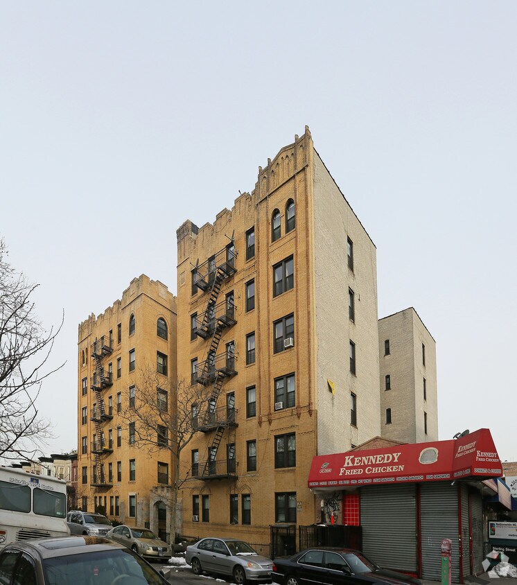
At 291 Sterling St in Brooklyn, NY, experience stylish living. The location of this community is on Sterling St. in Brooklyn. Schedule a time to check out the apartment floorplan options. The leasing staff is waiting to show you all that this community has in store. Drop by 291 Sterling St today.
291 Sterling St is an apartment community located in Kings County and the 11225 ZIP Code. This area is served by the New York City Geographic District #17 attendance zone.
High Speed Internet Access
Refrigerator
Smoke Free
Heating
Looking for a standout kind of neighborhood with a quick commute into Manhattan? Then look no further than Prospect Lefferts Gardens – or PLG.
Situated in central Brooklyn, Prospect Lefferts Gardens distinguishes itself with tree-lined roads, low-cost apartments, and unique businesses. Bordering the northern edge of Flatbrush, PLG lies south of Crown Heights.
Neighborhood highlights in PLG include proximity to Prospect Park and the Q Train at nearby subway stations. Flatbrush Avenue houses a lot of the local businesses like bars and restaurants. Nightlife is pretty on-point; locals enjoy a drink at Midwood Flats and Bluebird.
Learn more about living in Prospect Lefferts Gardens| Colleges & Universities | Distance | ||
|---|---|---|---|
| Colleges & Universities | Distance | ||
| Walk: | 11 min | 0.6 mi | |
| Drive: | 8 min | 2.5 mi | |
| Drive: | 7 min | 2.7 mi | |
| Drive: | 8 min | 3.0 mi |


Transportation options available in Brooklyn include Sterling Street, located 0.0 mile from 291 Sterling St. 291 Sterling St is near John F Kennedy International, located 11.4 miles or 21 minutes away, and LaGuardia, located 11.5 miles or 24 minutes away.
| Transit / Subway | Distance | ||
|---|---|---|---|
| Transit / Subway | Distance | ||
|
|
Walk: | 2 min | 0.0 mi |
|
|
Walk: | 6 min | 0.4 mi |
|
|
Walk: | 8 min | 0.5 mi |
|
|
Walk: | 9 min | 0.5 mi |
|
|
Walk: | 14 min | 0.7 mi |
| Commuter Rail | Distance | ||
|---|---|---|---|
| Commuter Rail | Distance | ||
|
|
Drive: | 5 min | 1.6 mi |
|
|
Drive: | 7 min | 2.5 mi |
|
|
Drive: | 8 min | 3.1 mi |
|
|
Drive: | 18 min | 7.2 mi |
|
|
Drive: | 19 min | 7.5 mi |
| Airports | Distance | ||
|---|---|---|---|
| Airports | Distance | ||
|
John F Kennedy International
|
Drive: | 21 min | 11.4 mi |
|
LaGuardia
|
Drive: | 24 min | 11.5 mi |
Time and distance from 291 Sterling St.
| Shopping Centers | Distance | ||
|---|---|---|---|
| Shopping Centers | Distance | ||
| Drive: | 4 min | 1.2 mi | |
| Drive: | 4 min | 1.6 mi | |
| Drive: | 5 min | 1.6 mi |
| Parks and Recreation | Distance | ||
|---|---|---|---|
| Parks and Recreation | Distance | ||
|
Wingate Park
|
Walk: | 12 min | 0.7 mi |
|
Prospect Park Audubon Center at the Boathouse
|
Walk: | 18 min | 0.9 mi |
|
Brooklyn Botanic Garden
|
Walk: | 19 min | 1.0 mi |
|
Prospect Park Zoo
|
Walk: | 20 min | 1.0 mi |
|
Brooklyn Children's Museum
|
Drive: | 5 min | 1.1 mi |
| Hospitals | Distance | ||
|---|---|---|---|
| Hospitals | Distance | ||
| Walk: | 16 min | 0.9 mi | |
| Walk: | 17 min | 0.9 mi | |
| Drive: | 4 min | 1.3 mi |
| Military Bases | Distance | ||
|---|---|---|---|
| Military Bases | Distance | ||
| Drive: | 17 min | 6.4 mi | |
| Drive: | 17 min | 8.1 mi |
What Are Walk Score®, Transit Score®, and Bike Score® Ratings?
Walk Score® measures the walkability of any address. Transit Score® measures access to public transit. Bike Score® measures the bikeability of any address.
What is a Sound Score Rating?
A Sound Score Rating aggregates noise caused by vehicle traffic, airplane traffic and local sources
291 Sterling St
Brooklyn, NY 11225


