
$1,250 / Month
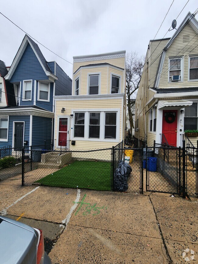
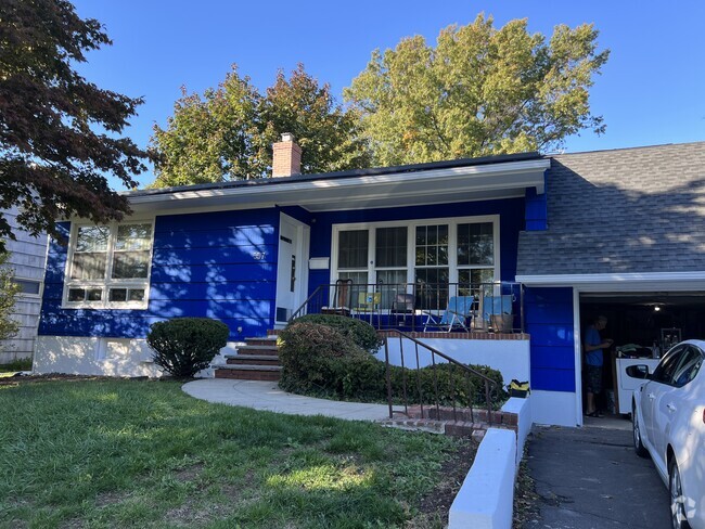
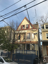
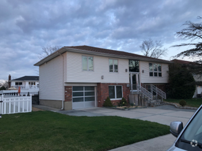
29 Melrose St
Brooklyn, NY 11206
2 Weeks Ago
Favorites
29 Melrose St

Favorites
Check Back Soon for Upcoming Availability
| Beds | Baths | Average SF |
|---|---|---|
| 2 Bedrooms 2 Bedrooms 2 Br | 2.5 Baths 2.5 Baths 2.5 Ba | 1,800 SF |
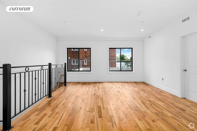
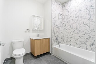
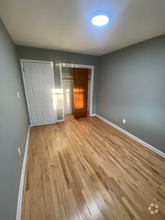
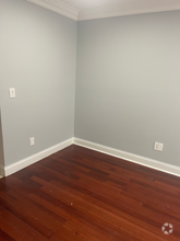
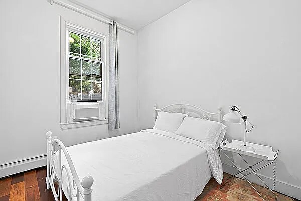
About This Property
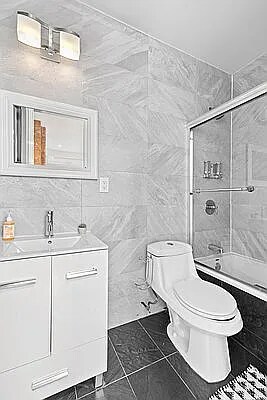
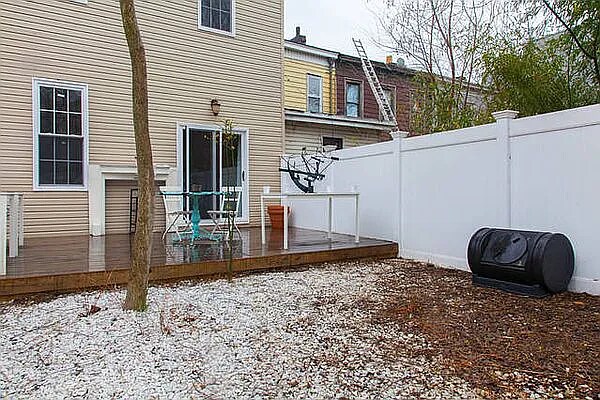
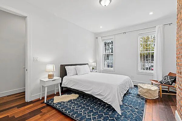
Room for rent in a 2 bedroom Apartment. Room available in a duplex garden apartment says it all! Looking for large living and dining areas, amazing private backyard, finished basement, central AC/heat, great separation between 2 bedrooms and ensuite in primary bedroom.
29 Melrose St is a house located in Kings County and the 11206 ZIP Code. This area is served by the Bedford Stuyvesant New Beginnings Charter School attendance zone.
House Features
- Wheelchair Accessible (Rooms)
Location
Get Directions
Neighboring Williamsburg to the east, Bushwick is a vibrant Brooklyn neighborhood known for its incredible street art, local shops, and diverse cuisine. Bushwick has historically served as a haven for immigrants, and now attracts scores of creative types to its many galleries and converted loft spaces.
In addition to a host of new local businesses, Bushwick offers residents exciting nightlife options and easy subway access. Colorful apartment buildings line quiet residential streets in Bushwick as well, providing plenty of rental opportunities to the community. Numerous neighborhood parks offer a tranquil reprieve from the big-city bustle.
Learn more about living in BushwickBelow are rent ranges for similar nearby apartments
| Beds | Average Size | Lowest | Typical | Premium |
|---|---|---|---|---|
| Studio Studio Studio | 588-589 Sq Ft | $1,200 | $2,126 | $3,700 |
| 1 Bed 1 Bed 1 Bed | 755-756 Sq Ft | $1,100 | $2,118 | $4,335 |
| 2 Beds 2 Beds 2 Beds | 1093-1094 Sq Ft | $1,430 | $2,690 | $6,819 |
| 3 Beds 3 Beds 3 Beds | 1520 Sq Ft | $1,859 | $3,255 | $7,766 |
| 4 Beds 4 Beds 4 Beds | 2926 Sq Ft | $2,600 | $4,525 | $9,000 |
Amenities
- Wheelchair Accessible (Rooms)
Education
| Colleges & Universities | Distance | ||
|---|---|---|---|
| Colleges & Universities | Distance | ||
| Drive: | 7 min | 2.0 mi | |
| Drive: | 7 min | 2.2 mi | |
| Drive: | 8 min | 3.0 mi | |
| Drive: | 11 min | 3.4 mi |
29 Melrose St is within 7 minutes or 2.0 miles from Pratt Institute. It is also near Saint Joseph's Coll, Brooklyn and Long Island Univ., Brooklyn.
Schools


Charter Elementary & Middle School
Grades K-8
730 Students
Nearby
Public Elementary School
Grades PK-5
304 Students
Attendance Zone
Charter High School
Grades 9-12
968 Students
Nearby
Private Elementary, Middle & High School
Grades PK-12
Nearby
Private Elementary & Middle School
Grades PK-8
296 Students
Nearby
Private Elementary & Middle School
Grades K-8
Nearby
School data provided by
 The GreatSchools Rating helps parents compare schools within a state based on a variety of school quality indicators and provides a helpful picture of how effectively each school serves all of its students. Ratings are on a scale of 1 (below average) to 10 (above average) and can include test scores, college readiness, academic progress, advanced courses, equity, discipline and attendance data. We also advise parents to visit schools, consider other information on school performance and programs, and consider family needs as part of the school selection process.
View GreatSchools Rating Methodology
View GreatSchools Rating Methodology
Transportation options available in Brooklyn include Myrtle Avenue, located 0.1 mile from 29 Melrose St. 29 Melrose St is near Laguardia, located 8.2 miles or 17 minutes away, and John F Kennedy International, located 12.0 miles or 21 minutes away.
| Transit / Subway | Distance | ||
|---|---|---|---|
| Transit / Subway | Distance | ||
|
|
Walk: | 2 min | 0.1 mi |
|
|
Walk: | 7 min | 0.4 mi |
|
|
Walk: | 10 min | 0.5 mi |
|
|
Walk: | 10 min | 0.5 mi |
|
|
Drive: | 4 min | 1.4 mi |
| Commuter Rail | Distance | ||
|---|---|---|---|
| Commuter Rail | Distance | ||
|
|
Drive: | 7 min | 2.3 mi |
|
|
Drive: | 6 min | 2.6 mi |
|
|
Drive: | 10 min | 3.4 mi |
|
|
Drive: | 12 min | 3.9 mi |
|
|
Drive: | 12 min | 4.2 mi |
| Airports | Distance | ||
|---|---|---|---|
| Airports | Distance | ||
|
Laguardia
|
Drive: | 17 min | 8.2 mi |
|
John F Kennedy International
|
Drive: | 21 min | 12.0 mi |
Time and distance from 29 Melrose St.
| Shopping Centers | Distance | ||
|---|---|---|---|
| Shopping Centers | Distance | ||
| Drive: | 4 min | 1.7 mi | |
| Drive: | 6 min | 2.1 mi | |
| Drive: | 7 min | 2.4 mi |
29 Melrose St has 3 shopping centers within 2.4 miles, which is about a 7-minute drive. The miles and minutes will be for the farthest away property.
| Parks and Recreation | Distance | ||
|---|---|---|---|
| Parks and Recreation | Distance | ||
|
Martinez Playground
|
Walk: | 21 min | 1.1 mi |
|
Maria Hernandez Park
|
Drive: | 3 min | 1.2 mi |
|
Sternberg Park
|
Drive: | 3 min | 1.2 mi |
|
Hattie Carthan Garden
|
Drive: | 5 min | 1.6 mi |
|
St. John's Park
|
Drive: | 6 min | 1.8 mi |
29 Melrose St has 5 parks within 1.8 miles, including Maria Hernandez Park, Sternberg Park, and Martinez Playground.
| Hospitals | Distance | ||
|---|---|---|---|
| Hospitals | Distance | ||
| Walk: | 8 min | 0.4 mi | |
| Drive: | 3 min | 1.3 mi | |
| Drive: | 6 min | 1.8 mi |
29 Melrose St has 3 hospitals within 1.8 miles, the nearest is Woodhull Medical & Mental Health Center which is 0.4 mile away and a 8 minute walk.
| Military Bases | Distance | ||
|---|---|---|---|
| Military Bases | Distance | ||
| Drive: | 18 min | 6.7 mi | |
| Drive: | 22 min | 11.1 mi |
29 Melrose St is 6.7 miles from Governors Island Support Center, and is convenient to other military bases, including Fort Hamilton.
You May Also Like
Similar Rentals Nearby
What Are Walk Score®, Transit Score®, and Bike Score® Ratings?
Walk Score® measures the walkability of any address. Transit Score® measures access to public transit. Bike Score® measures the bikeability of any address.
What is a Sound Score Rating?
A Sound Score Rating aggregates noise caused by vehicle traffic, airplane traffic and local sources
29 Melrose St
Brooklyn, NY 11206